Global warming is influencing where tropical cyclones rage

Orbital view of hurricanes: three giant white spirals on blue background with green land area to left.

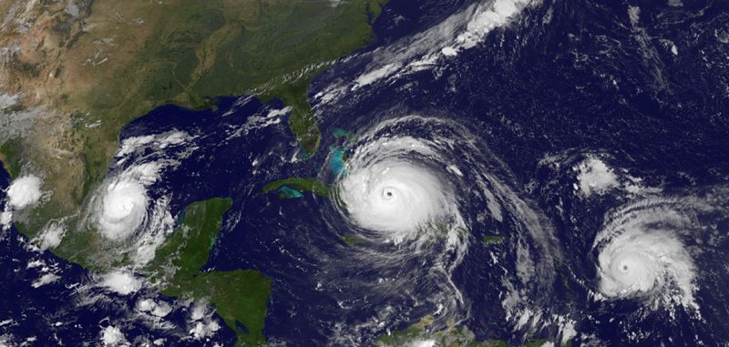
During one of the most active hurricane seasons in recent years, 3 simultaneous hurricanes – Katia, Irma and Jose – were captured in this satellite image on September 8, 2017. Image via NOAA.

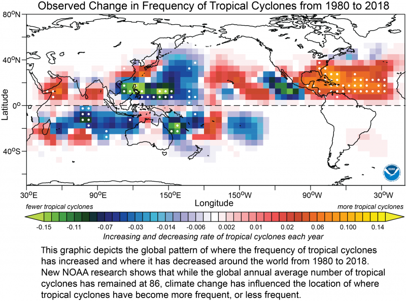
Tropical cyclones are basically hurricanes by another name. Over the past 40 years, the global average number of tropical cyclones per year has stayed at 86, but global warming has been influencing where these deadly storms are happening. According to new study published May 4, 2020 in the peer-reviewed Proceedings of the National Academy of Sciences, the number of tropical cyclones has been rising since 1980 in the North Atlantic and Central Pacific, while storms have been declining in the Western Pacific and in the South Indian Ocean.

The researchers used climate models to determine that greenhouse gases, human-made aerosols – including particulate pollution- and volcanic eruptions were influencing where tropical cyclones were hitting. Hiroyuki Murakami is a climate researcher at NOAA’s Geophysical Fluid Dynamics Laboratory and lead author of the study. He said in a statement:

We show for the first time that this observed geographic pattern cannot be explained only by natural variability.
Map of the world with green, blue, and red blotches across the middle along, above, and below the equator.

View larger. | Green and blue areas represent fewer than normal storms, and red areas represent greater numbers of storms. Image via NOAA.

The researchers explained that greenhouse gases warming the upper atmosphere and the ocean combine to create a more stable atmosphere, with less chance that convection of air currents will help spawn and build up tropical cyclones.

In addition, particulate pollution – solid and liquid droplets suspended in the air – and other aerosols help create clouds and reflect sunlight away from the earth, causing cooling, Murakami said. The decline in particulate pollution due to pollution control measures may increase the warming of the ocean by allowing more sunlight to be absorbed by the ocean.

Diminishing human-made aerosols is one of the reasons for the active tropical cyclones in the North Atlantic over the last 40 years, Murakami said. However, toward the end of this century, tropical cyclones in the North Atlantic are projected to decrease due to the “calming” effect of greenhouse gases.

Volcanic eruptions have also altered the location of where tropical cyclones have occurred, according to the research:

For example, the major eruptions in El Chichón in Mexico in 1982 and Pinatubo in the Philippines in 1991 caused the atmosphere of the northern hemisphere to cool, which shifted tropical cyclone activity southward for a few years. Ocean warming has resumed since 2000, leading to increased tropical cyclone activity in the Northern Hemisphere.

Looking ahead, climate models project decreases in tropical cyclones toward the end of the 21st century, from the current annual average of 86 to about 69 worldwide, according to the new study. Declines are projected in most regions except in the Central Pacific, including Hawaii, where tropical cyclones activity is expected to increase. But despite a projected decline, many of these cyclones will be significantly more severe, say the researchers. Why? Rising sea surface temperatures fuel the intensity and destructiveness of tropical storms.

Bottom line: A new study says that although the global average number of tropical cyclones per year hasn’t changed for 40 years, climate change has been influencing the locations of these deadly storms.

Source: Detected climatic change in global distribution of tropical cyclones

Via NOAA


from EarthSky https://ift.tt/2Xis9WC
Orbital view of hurricanes: three giant white spirals on blue background with green land area to left.

During one of the most active hurricane seasons in recent years, 3 simultaneous hurricanes – Katia, Irma and Jose – were captured in this satellite image on September 8, 2017. Image via NOAA.

Tropical cyclones are basically hurricanes by another name. Over the past 40 years, the global average number of tropical cyclones per year has stayed at 86, but global warming has been influencing where these deadly storms are happening. According to new study published May 4, 2020 in the peer-reviewed Proceedings of the National Academy of Sciences, the number of tropical cyclones has been rising since 1980 in the North Atlantic and Central Pacific, while storms have been declining in the Western Pacific and in the South Indian Ocean.

The researchers used climate models to determine that greenhouse gases, human-made aerosols – including particulate pollution- and volcanic eruptions were influencing where tropical cyclones were hitting. Hiroyuki Murakami is a climate researcher at NOAA’s Geophysical Fluid Dynamics Laboratory and lead author of the study. He said in a statement:

We show for the first time that this observed geographic pattern cannot be explained only by natural variability.

Map of the world with green, blue, and red blotches across the middle along, above, and below the equator.

View larger. | Green and blue areas represent fewer than normal storms, and red areas represent greater numbers of storms. Image via NOAA.

The researchers explained that greenhouse gases warming the upper atmosphere and the ocean combine to create a more stable atmosphere, with less chance that convection of air currents will help spawn and build up tropical cyclones.

In addition, particulate pollution – solid and liquid droplets suspended in the air – and other aerosols help create clouds and reflect sunlight away from the earth, causing cooling, Murakami said. The decline in particulate pollution due to pollution control measures may increase the warming of the ocean by allowing more sunlight to be absorbed by the ocean.

Diminishing human-made aerosols is one of the reasons for the active tropical cyclones in the North Atlantic over the last 40 years, Murakami said. However, toward the end of this century, tropical cyclones in the North Atlantic are projected to decrease due to the “calming” effect of greenhouse gases.

Volcanic eruptions have also altered the location of where tropical cyclones have occurred, according to the research:

For example, the major eruptions in El Chichón in Mexico in 1982 and Pinatubo in the Philippines in 1991 caused the atmosphere of the northern hemisphere to cool, which shifted tropical cyclone activity southward for a few years. Ocean warming has resumed since 2000, leading to increased tropical cyclone activity in the Northern Hemisphere.

Looking ahead, climate models project decreases in tropical cyclones toward the end of the 21st century, from the current annual average of 86 to about 69 worldwide, according to the new study. Declines are projected in most regions except in the Central Pacific, including Hawaii, where tropical cyclones activity is expected to increase. But despite a projected decline, many of these cyclones will be significantly more severe, say the researchers. Why? Rising sea surface temperatures fuel the intensity and destructiveness of tropical storms.

Bottom line: A new study says that although the global average number of tropical cyclones per year hasn’t changed for 40 years, climate change has been influencing the locations of these deadly storms.

Source: Detected climatic change in global distribution of tropical cyclones

Via NOAA


from EarthSky https://ift.tt/2Xis9WC
The difference between ‘signs’ and constellations

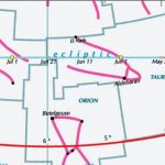
Chart showing the evening sky with constellations and ecliptic.

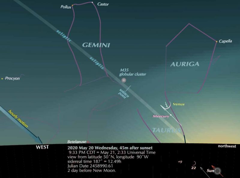
Here is the sun (below the horizon) at its May 20 position. On May 20, the sun enters the astrological “sign” of Gemini. Yet, as you can see from this chart, the actual constellation Gemini is still above the horizon when the sun is below it. The sun won’t enter the constellation Gemini until July. Chart via Guy Ottewell’s blog.

Guy Ottewell published this post earlier this week under the title The Difference Made by 2 Thousand Years. Reprinted here with permission.

On Wednesday, May 20, the sun enters the astrological sign of Gemini. This gives us a rather good way of seeing the difference between astrological signs and the constellations as defined by astronomers.

The signs of Aries, Taurus, etc. – still used in astrology – are 30°-wide bands along the ecliptic, starting at longitude 0°, which is also known as the First Point of Aries. The constellations are areas of the starry sky, defined since 1930 by lines. The two coincided, somewhat more than 2,000 years ago, when the system of signs was defined. But precession – the wobbling of Earth’s spin axis over a cycle of 25,800 years – has made them increasingly divergent.

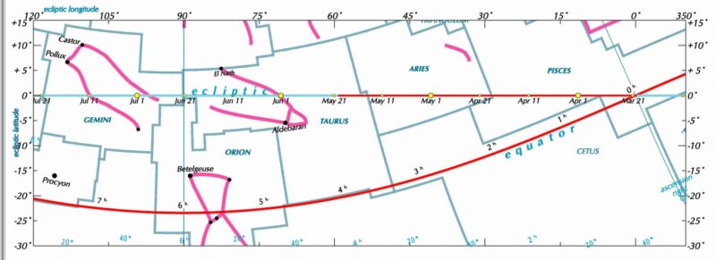
The chart below shows the sun’s travel from March 20 (the spring or vernal equinox) to May 20. You can see that the sun does indeed reach longitude 60° on the ecliptic. But this brings it to the beginning (roughly) of constellation Taurus, not Gemini. It will have to travel another 30° – two months – to enter Gemini.

Chart with ecliptic line going through formal boundaries of constellations, equator also marked.

View larger. | Chart showing the sun’s movement through the constellations, as defined by astronomers. You can see that sun won’t enter Gemini until July. Chart via Guy Ottewell’s blog.

The stars and constellations stay fixed. What shifts over time is the celestial equator – the “belt,” you could say, of the spinning Earth – and the mapping system based on it.

Mentally move them. Imagine the sun’s March-to-May track, and the celestial equator – the two features I’ve emphasized with red on the chart above – slid 30° to the left (east), while everything else stays in place. The crossing-point of equator and ecliptic – which is the zero point for longitude – is 30° to the left: it is at what is now longitude 30°, the beginning of Aries. So it really is then the First Point of Aries. In this mental projection, the sun is at the First Point of Aries in March, and arrives at the gates of Gemini at this time in May.

This was how things stood when the system of signs was agreed, around 2,000 years ago.

You can, with some imagination, see it in your sky, or on the chart at the top of this point.

There is the sun (below the horizon) at its May 20 position where it enters the astrological sign of Gemini. If this were 150 BC it would be 30° on, at what is now longitude 90° – the solstice point of our time, by the feet of Gemini.

With less need of imagination, and more of binocular aid, you can see Venus for one of the last times before it plunge into the glare of the sun. The arrows through the moving bodies indicate their motion over five days, against the starry background. So you can see that as the sun continues to advance in its usual way, Venus is falling back toward it.

And in the background Mercury is hurrying out toward its eastern elongation of June 4. So the two inner planets will have a conjunction on May 22, less than a degree apart. I hope I haven’t already made the joke about the planets failing to observe social distancing.

Read more from Guy Ottewell.

Bottom line: When – astrologically – the sun enters the “sign” of Gemini, it is still nearly two months away from entering the constellation Gemini in the sky.


from EarthSky https://ift.tt/2XijbZs

How do hurricanes get their names?

Gigantic pure white spiral with black dot in the center, against a blue background.

The Atlantic hurricane season begins on June 1 and ends November 30. This is Hurricane Florence, seen from the International Space Station (ISS) on the morning of September 12, 2018. Image via NASA.

Ever wonder how hurricanes get their names? And why do hurricanes have names at all? Meteorologists long ago learned that naming tropical storms and hurricanes helps people remember the storms, communicate about them more effectively, and so stay safer if and when a particular storm strikes a coast. These experts assign names to hurricanes according to a formal list of names that is approved before the start of each hurricane season. The U.S. National Hurricane Center started this practice in the early 1950s. Now, the World Meteorological Organization generates and maintains the list of hurricane names.

Here are the hurricane names for 2020:

Atlantic hurricane names (season runs from June 1 to November 30) are Arthur, Bertha, Cristobal, Dolly, Edouard, Fay, Gonzalo, Hanna, Isaias, Josephine, Kyle, Laura, Marco, Nana, Omar, Paulette, Rene, Sally, Teddy, Vicky, and Wilfred.

Eastern North Pacific hurricane names (season runs from May 15 to November 30) are Amanda, Boris, Cristina, Douglas, Elida, Fausto, Genevieve, Hernan, Iselle, Julio, Karina, Lowell, Marie, Norbert, Odalys, Polo, Rachel, Simon, Trudy, Vance, Winnie, Xavier, Yolanda, and Zeke.  The eastern North Pacific hurricane .

If you’re interested, you can view those names, and names for upcoming years, here.

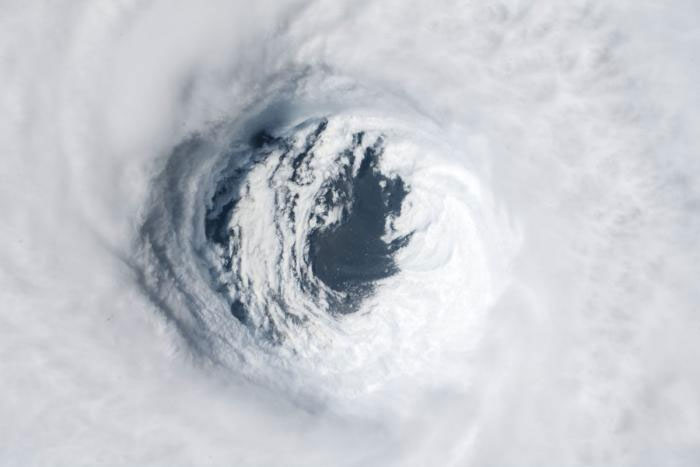
Huge swirling mass of white clouds with dark hole in center.

The eyewall of Hurricane Michael photographed on October 10, 2018, by astronauts onboard the International Space Station. Hurricane Michael was a category 5 storm when it made landfall in the vicinity of Mexico Beach, Florida, on October 10. Image via NASA.

How and why did hurricanes first begin receiving names? While people have been naming major storms for hundreds of years, most hurricanes were originally designated by a system of latitude-longitude numbers, which was useful to meteorologists trying to track these storms. Unfortunately, this system was confusing to people living on coasts seeking hurricane information.

In the early 1950s, a formal practice for storm naming was first developed for the Atlantic Ocean by the U.S. National Hurricane Center. At that time, storms were named according to a phonetic alphabet (e.g., Able, Baker, Charlie) and the names used were the same for each hurricane season; in other words, the first hurricane of a season was always named “Able,” the second “Baker,” and so on.

In 1953, to avoid the repetitive use of names, the system was revised so that storms would be given female names. By doing this, the National Weather Service was mimicking the habit of naval meteorologists, who named the storms after women, much as ships at sea were traditionally named for women.

In 1978–1979, the system was revised again to include both female and male hurricane names.

See the complete history of naming hurricanes, from NOAA

When does a storm receive a name? Tropical storms are given names when they display a rotating circulation pattern and wind speeds of 39 miles per hour (63 kilometers per hour). A tropical storm develops into a hurricane when wind speeds reach 74 mph (119 kph).

Lists of hurricane names have been developed for many of the major ocean basins around the world. Today, there are six lists of hurricane names in use for Atlantic Ocean and Eastern North Pacific storms. These lists rotate, one each year. That means the list of this year’s hurricane names for each basin will come up again six years from now. There’s an exception to this practice, however. The names of hurricanes that are particularly damaging are retired for legal, cultural sensitivity, and historical reasons. For example, the use of the name Katrina was retired in 2005 following the devastating impact that Hurricane Katrina had on New Orleans. In March 2019, the World Meteorological Organization removed the names Florence and Michael from its lists for the Atlantic Ocean basin and replaced the names with Francine and Milton. Hurricanes Florence and Michael, which respectively struck the coasts of North Carolina and Florida in 2018, each caused tremendous damage and dozens of fatalities.

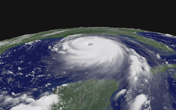
Oblique orbital view of large round white hurricane with distinct spirals and eye, in Gulf of Mexico with green land areas visible.

Hurricane Katrina on August 28, 2005. Image via NASA.

The name Dorian of the category 5 hurricane that devastated the Bahamas in early September of 2019 is certain to be retired given the extensive fatalities (84 in total) and economic damages that it caused along its path. Dorian was in fact one of the strongest Atlantic hurricanes on record. However, the decision to retire the name by the World Meteorological Organization (WMO) in the spring of 2020 had to be postponed because of the current coronavirus panademic. The retirement of hurricane names for both the 2019 and 2020 seasons will be discussed jointly at next year’s hurricane committee meeting, according to a WMO spokesperson.

Elongated white spiral on blue sea with land areas outlined.

Satellite image of Hurricane Dorian, captured by GOES East on September 2, 2019. Image via NOAA.

Bottom line: The naming of hurricanes helps people communicate about the storms more effectively. The World Meteorological Organization manages the formal system by which hurricanes receive their names. The names for each ocean basin are published in lists before the hurricane season.

Help EarthSky keep going! Please donate.


from EarthSky https://ift.tt/2ZGHQpK

Deneb, tail of Cygnus the Swan

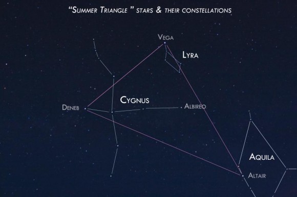
Tonight, look for Deneb, the brightest star in the constellation Cygnus the Swan. The night sky chart at the top of this post presents the view toward the northeast in mid-to-late evening during the month of May. It’s the view from mid-northern latitudes.

This star is part of not one but two striking star patterns. And it’s one of the most distant stars we can see with the eye alone, well over 1,000 light-years away.

Here is the Summer Triangle asterism - three bright stars in three different constellations - as photographed by EarthSky Facebook friend Susan Jensen in Odessa, Washington. Thank you, Susan, for your excellent and beautiful work!

Here is the Summer Triangle asterism – three bright stars in three different constellations – as photographed by EarthSky Facebook friend Susan Jensen in Odessa, Washington. Thank you, Susan!

Deneb is part of the Summer Triangle pattern. Deneb – along with the stars Vega and Altair – is part of the famous Summer Triangle asterism, which will be well up in the east in mid-evening next month. On these Northern Hemisphere late spring evenings, you might not be able to see the whole Summer Triangle until later at night. The star Altair will be the last of these three stars to rise. But you can see the bright star Deneb to the lower left of Vega, the Summer Triangle’s brightest star.

Enjoying EarthSky so far? Sign up for our free daily newsletter today!

Deneb is also part of a smaller, cross-like pattern. Deneb is the brightest star in the constellation Cygnus the Swan. If you look at the cross-like pattern indicated on the chart at the top of this post, you might be able to imagine Deneb as the point marking the short tail of a long-necked swan flying toward the south. This is how early Arabian stargazers saw it. The name Deneb comes from the Arabic language and means tail, and in skylore Deneb is often said to be the Tail of the Swan. The little star Albireo marks the Swan’s Head.

But there’s another way to see this pattern of stars that works equally well. In more modern skylore, this pattern is sometimes called the Northern Cross. It looks like a cross, right? If you prefer to see the Cross instead of the Swan, Deneb marks the head of the Cross.

Cross or Swan … this is a lovely pattern to pick out on the sky’s dome.

Astronomers know that Deneb is one of the most distant stars we can see with the eye alone. The exact distance to Deneb can only be estimated, with estimates ranging from about 1,425 light-years to perhaps as much as 7,000 light-years. At any of these estimated distances, Deneb is one of the farthest stars the unaided human eye can see. It is so far, that the light that reaches the Earth today started on its journey well more than 1,000 years ago.

More about Deneb: Very distant and very luminous

Bottom line: The star Deneb is part of the Summer Triangle asterism. And it’s part of the constellation Cygnus the Swan, which can also be seen as a Cross. Look for the star Deneb tonight! At well over 1,000 light-years away, it’s one of the most distant stars we can see with the eye alone.

A planisphere is a virtually indispensable tool for beginning stargazers. Order your EarthSky planisphere from our store.


from EarthSky https://ift.tt/2LGQFv9

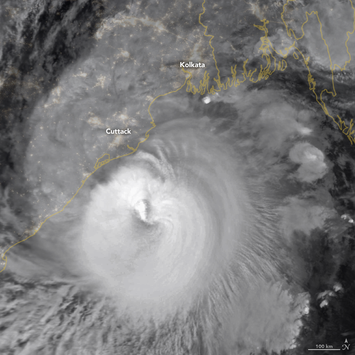
Tropical Cyclone Amphan

A large hurricane, or tropical cyclone, approaching India from the east.

NASA Earth Observatory image by Lauren Dauphin, using MODIS data from NASA EOSDIS/LANCE and GIBS/Worldview and using Black Marble data from NASA/GSFC.

Kathryn Hansen of NASA Earth Observatory wrote:

Millions of people prepared to evacuate as Tropical Cyclone Amphan approached eastern India and Bangladesh on May 19, 2020. The potent storm is expected to make landfall by midday on May 20 with dangerous wind, rain, storm surges, and flooding.

This image shows the storm at 16:15 Universal Time (9:45 p.m. India Standard Time) on May 19 as it moved north-northeast over the Bay of Bengal. The image is a composite of brightness temperature data acquired by the Moderate Resolution Imaging Spectroradiometer (MODIS) on NASA’s Terra satellite, overlaid on Black Marble nighttime satellite imagery.

Around the time this image was acquired, Amphan had sustained winds of 100 knots (185 km/115 miles per hour). That is the equivalent of a category 3 storm on the Saffir-Simpson wind scale. The storm had reached Category 5 force on May 18.

Bottom line: Satellite photo of Tropical Cyclone Amphan, as viewed from space.

Via NASA Earth Observatory


from EarthSky https://ift.tt/2ALyen5

New moon is May 22, 2020

Extremely thin, threadlike crescent against blue background.

Youngest possible lunar crescent, with the moon’s age being exactly zero when this photo was taken — at the instant of new moon – 07:14 UTC on July 8, 2013. Image by Thierry Legault.

When the moon is new, it’s most nearly between the Earth and sun for any particular month. There’s a new moon about once a month, because the moon takes about a month to orbit Earth. Most of the time, the new moon passes not in front of the sun, but simply near it in our sky. That’s why, in most months, there’s no solar eclipse.

The moon must be at the new phase in order for a solar eclipse to take place.

The photo of a new moon at the top of this page shows the moon as it passed near the sun on July 8, 2013. There was no eclipse that day; it was an ordinary new moon. New moons typically can’t be seen, or at least they can’t without special equipment and a lot of moon-photography experience. Thierry Legault was able to catch the photo at top – the moon at the instant it was new – because the moon that month passed to one side of the sun, and the faintest of lunar crescents was visible.

Either way – in front of the sun or just near it – on the day of new moon, the moon travels across the sky with the sun during the day, hidden in the sun’s glare.

Some people use the term new moon for a thin crescent moon visible in the west after sunset. You always see these little crescents – which set shortly after the sun – a day or two after each month’s new moon. Astronomers don’t call these little crescent moons new moons, however. In the language of astronomy, this slim crescent is called a young moon.

New moons, and young moons, are fascinating to many. The Farmer’s Almanac, for example, still offers information on gardening by the moon. And many cultures have holidays based on moon phases.

Bottom line: New moons generally can’t be seen. They cross the sky with the sun during the day. This month’s new moon happens on May 22 at 17:40 UTC.

Read more: What’s the youngest moon you can see?

Read more: 4 keys to understanding moon phases

Help EarthSky keep going! Please donate.


from EarthSky https://ift.tt/2QpMvsB

Why is Earth’s magnetic north pole drifting so rapidly?

You probably know that a compass doesn’t point to true north. Earth’s geographic north pole – and magnetic north pole – were first recognized as two different places in 1831. Until the early 1990s, the magnetic North Pole was known to lie some 1,000 miles south of true north, in Canada. Yet, as scientists realized, the location of magnetic north was not fixed. Magnetic north was drifting at a rate of up to about 9 miles (15 km) a year. Since the 1990s, however, the drift of Earth’s magnetic north pole has turned into “more of a sprint,” scientists say. Its present speed is about 30 to nearly 40 miles a year (50-60 km a year) toward Siberia. And now – using satellite measurements – scientists in Europe have helped confirm a theory as to why Earth’s magnetic north pole is drifting so rapidly.

The European Space Agency (ESA) released this interesting article on May 14, 2020. It describes a new study in the peer-reviewed journal Nature Geoscience that describes the theory of “tussling magnetic blobs deep below Earth’s surface” at the root of the phenomenon of rapid magnetic pole drift since the 1990s. ESA said:

In late October 2017, [the magnetic north pole] crossed the International Date Line, passing within 390 km [242 miles] of the geographic pole, and is now heading south …

Schematics of the inside of Earth, viewed from earthly north, showing the changing shape of blobs of magnetic flux over time.

Tussling magnetic blobs deep below Earth’s surface appear to be at the root of the phenomenon of rapid magnetic pole drift since the 1990s. Image via ESA.

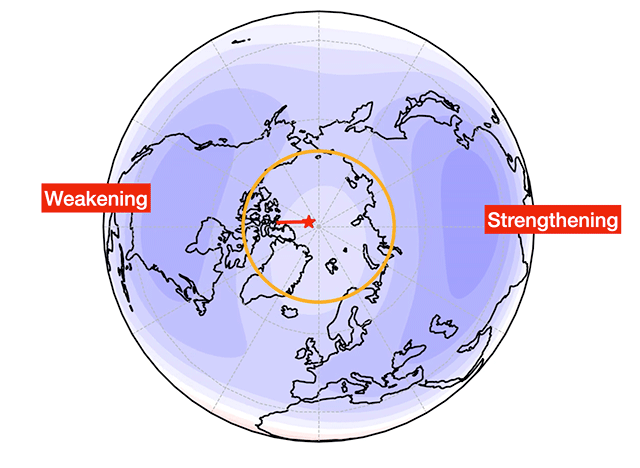
At present, the Siberian blob appears to be winning in this magnetic “tug of war.” Image via Phil Livermore/ BBC.

In our modern world, it’s not just compasses that are affected by the drift of Earth’s magnetic north pole. ESA explained:

One of the practical consequences of this is that the World Magnetic Model has to be updated periodically with the pole’s current location. The model is vital for many navigation systems used by ships, Google maps and smartphones, for example.

That’s why the subject of magnetic north is such a vital one to our world, and why ESA’s Living Planet Symposium last year featured a talk from scientists at the University of Leeds in the U.K. about their findings on magnetic north, using SWARM satellite data. The Swarm satellites carry sophisticated magnetometers. Their goal, in part, is to provide a survey of Earth’s magnetic field. ESA said:

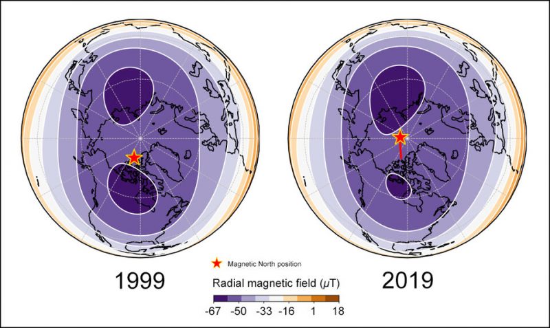
The data showed that the position of the north magnetic pole is determined largely by a balance, or tug-of-war, between two large lobes of negative flux at the boundary between Earth’s core and mantle under Canada.

Phil Livermore, from the University of Leeds, said:

By analyzing magnetic field maps and how they change over time, we can now pinpoint that a change in the circulation pattern of flow underneath Canada has caused a patch of magnetic field at the edge of the core, deep within the Earth, to be stretched out. This has weakened the Canadian patch and resulted in the pole shifting towards Siberia.

The big question, these scientists say, is whether the pole will ever return to Canada or continue heading south. Livermore explained:

Models of the magnetic field inside the core suggest that, at least for the next few decades, the pole will continue to drift towards Siberia.

However, given that the pole’s position is governed by this delicate balance between the Canadian and Siberian patch, it would take only a small adjustment of the field within the core to send the pole back to Canada.

Bottom line: Scientists studying the drift of Earth’s magnetic north pole have pinpointed a change in the circulation pattern of magnetic blobs deep below Earth’s surface. They’ve learned a change in the flow underneath Canada has caused a patch of magnetic field at the edge of Earth’s core, deep within the Earth, to be stretched out. This has weakened the Canadian patch and resulted in the pole shifting towards Siberia.

Source: Recent north magnetic pole acceleration towards Siberia caused by flux lobe elongation

Via ESA

Read more from the BBC: Scientists explain magnetic pole’s wanderings


from EarthSky https://ift.tt/2zeV0TV