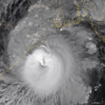

NASA Earth Observatory image by Lauren Dauphin, using MODIS data from NASA EOSDIS/LANCE and GIBS/Worldview and using Black Marble data from NASA/GSFC.
Kathryn Hansen of NASA Earth Observatory wrote:
Millions of people prepared to evacuate as Tropical Cyclone Amphan approached eastern India and Bangladesh on May 19, 2020. The potent storm is expected to make landfall by midday on May 20 with dangerous wind, rain, storm surges, and flooding.
This image shows the storm at 16:15 Universal Time (9:45 p.m. India Standard Time) on May 19 as it moved north-northeast over the Bay of Bengal. The image is a composite of brightness temperature data acquired by the Moderate Resolution Imaging Spectroradiometer (MODIS) on NASA’s Terra satellite, overlaid on Black Marble nighttime satellite imagery.
Around the time this image was acquired, Amphan had sustained winds of 100 knots (185 km/115 miles per hour). That is the equivalent of a category 3 storm on the Saffir-Simpson wind scale. The storm had reached Category 5 force on May 18.
Bottom line: Satellite photo of Tropical Cyclone Amphan, as viewed from space.
from EarthSky https://ift.tt/2ALyen5

Aucun commentaire:
Enregistrer un commentaire