
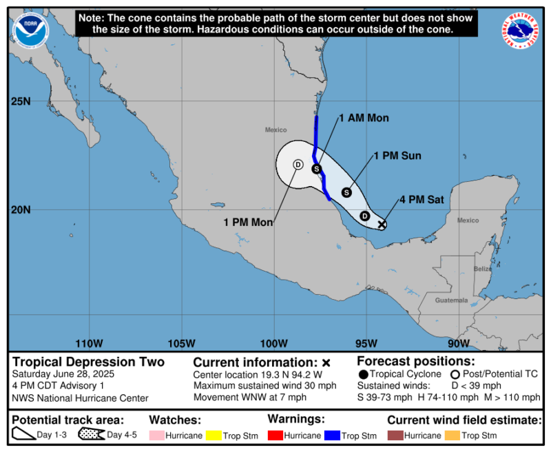
Tropical Depression Two to become Tropical Storm Barry
As of Sunday morning, June 29, 2025, a tropical storm warning is in effect for Mexico’s Gulf Coast from Boca de Catan southward to Tecolutla, according to the U.S. National Hurricane Center (NHC). Tropical Depression Two, now in the Gulf, is expected to strengthen into Tropical Storm Barry on Sunday. It’s expected to make landfall on the Gulf Coast of Mexico Sunday evening with winds speeds of more than 50 miles per hour (80 kph).
The tropical depression is then expected to weaken rather quickly over the mountainous terrain of central Mexico by early in the week. So this storm is expected to be short-lived, but impactful along the Mexican Gulf Coast.
Tropical Depression Two is the 2nd tropical cyclone of the Atlantic hurricane season, formed in the Bay of Campeche Saturday evening. Among its expected impacts, the NHC said:
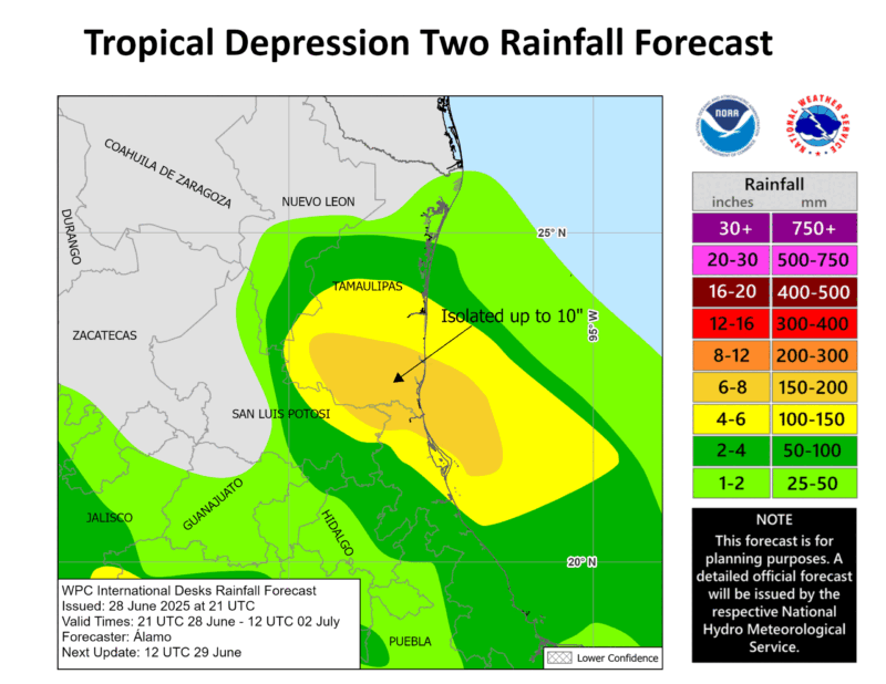
Tropical Depression Two is expected to produce rainfall totals of 3 to 6 inches (8 to 15 cm), with isolated maximum totals of 10 inches (25 cm), across the Mexican states of Veracruz, San Luis Potosi, and Tamaulipas through Monday. This rainfall may produce life-threatening flooding and mudslides, especially in areas of steep terrain.
It currently has sustained winds of 30 miles per hour (48 kph), and is moving to the west-northwest at 7 miles per hour (11 kph).
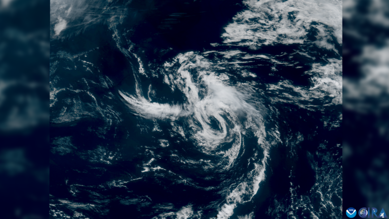
Wind speeds as of Saturday evening
Hurricane hunter aircraft found a closed center of circulation while investigating on Saturday. Then, using satellite data to estimate winds, the National Hurricane Center also saw there was a closed center and was able to estimate the current wind speeds, while noticing gradual strengthening. As of Saturday evening, It currently has sustained winds of 30 miles per hour (48 kph), and is moving to the west-northwest at 7 miles per hour (11 kph).
While winds are expected to get stronger, the storm is currently fighting strong wind shear. This wind shear (which is the change of wind direction and/or speed with height) is keeping the depression from getting stronger quickly, but despite the wind shear, warm waters in the Bay of Campeche and across the Gulf (as well as no dry air or Saharan dust) are fueling the system’s development.
So while it might not become a very strong storm, tropical storms conditions are likely as the system continues to develop.
Heavy rain forecast
Heavy rain is also expected for parts of eastern Mexico. While most forecasts call for 3 to 6 inches (8 to 15 cm) of rain, the states of Veracruz, San Luis Potosí, and Tamaulipas could receive as much as 10 inches (25 cm) of rain, which could cause flash and urban flooding. Remember to stay up to date with the forecast through NOAA’s National Hurricane Center.
Tropical Depression vs Tropical Storm
While Tropical Depression Two is expected to become Tropical Storm Barry, there is a difference between a depression and a storm. Both depressions and storms are areas of low pressure (cyclones) that have formed over warm ocean water, but think of a tropical depression as the “start.” A tropical depression is an organized low pressure with thunderstorms around the center, just like a tropical storm, but a tropical depression is weaker. Tropical depressions have sustained winds of 38 miles per hour (61 kph) or less. As soon as the depression has sustained winds of 39 miles per hour (63 kph) or greater, it is no longer a depression and is upgraded to a tropical storm, and then named. Once a tropical storm has sustained winds of 74 miles per hour (119 kph) or greater, it is then considered a hurricane.
The Atlantic hurricane season so far
It’s still very early in the Atlantic hurricane season, since it only started June 1, but this is already our second system. The first named storm, Tropical Storm Andrea, very quietly formed Tuesday, June 24, in the open Atlantic between Bermuda and the Azores. While not a strong or long-lasting storm, Andrea brought no threats to land, and quickly moved east-northeast before weakening to a non-tropical area of low pressure late Tuesday night, not even lasting a full 24 hours. Andrea was “on time” in terms of when we typically see our first named storm during the Atlantic Hurricane Season. On average, the first named storm develops around June 20, but our second named storm typically doesn’t develop until the middle of July. With Tropical Storm Barry likely developing near Mexico, it’s very possible we will have two named storms before the end of June. While this is a little earlier than what is considered average, it’s not that unusual. However the National Oceanic and Atmospheric Administration is forecasting an above-average hurricane season.
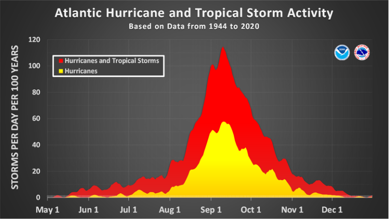
When hurricanes peak
While the Atlantic hurricane season runs from June 1 through November 30, the season doesn’t normally reach its peak until the middle of September. This is when the ocean temperatures are typically at their warmest (remember, it takes water longer to warm up, but it holds onto heat longer than land). Also, wind shear across the main development region of the Atlantic is lower, and Saharan dust starts to become less prevalent.
We also tend to see more tropical waves emerging off Africa due to the West African monsoon. These tropical waves can then tap into the warm water without as much dust cutting off their moisture supply, and without as much wind shear tearing them apart.
We are still months away from this peak, so remember to always be prepared for whatever hurricane season could bring. It takes only one storm to impact you.
Bottom Line: A tropical depression is likely to become Tropical Storm Barry and bring heavy rain and tropical storm-force winds to eastern Mexico. This storm will be short-lived, but impactful along the Mexican Gulf Coast.
The post Tropical Depression Two to strengthen and strike Sunday first appeared on EarthSky.
from EarthSky https://ift.tt/CoqrQY0
Tropical Depression Two to become Tropical Storm Barry
As of Sunday morning, June 29, 2025, a tropical storm warning is in effect for Mexico’s Gulf Coast from Boca de Catan southward to Tecolutla, according to the U.S. National Hurricane Center (NHC). Tropical Depression Two, now in the Gulf, is expected to strengthen into Tropical Storm Barry on Sunday. It’s expected to make landfall on the Gulf Coast of Mexico Sunday evening with winds speeds of more than 50 miles per hour (80 kph).
The tropical depression is then expected to weaken rather quickly over the mountainous terrain of central Mexico by early in the week. So this storm is expected to be short-lived, but impactful along the Mexican Gulf Coast.
Tropical Depression Two is the 2nd tropical cyclone of the Atlantic hurricane season, formed in the Bay of Campeche Saturday evening. Among its expected impacts, the NHC said:
Tropical Depression Two is expected to produce rainfall totals of 3 to 6 inches (8 to 15 cm), with isolated maximum totals of 10 inches (25 cm), across the Mexican states of Veracruz, San Luis Potosi, and Tamaulipas through Monday. This rainfall may produce life-threatening flooding and mudslides, especially in areas of steep terrain.
It currently has sustained winds of 30 miles per hour (48 kph), and is moving to the west-northwest at 7 miles per hour (11 kph).
Wind speeds as of Saturday evening
Hurricane hunter aircraft found a closed center of circulation while investigating on Saturday. Then, using satellite data to estimate winds, the National Hurricane Center also saw there was a closed center and was able to estimate the current wind speeds, while noticing gradual strengthening. As of Saturday evening, It currently has sustained winds of 30 miles per hour (48 kph), and is moving to the west-northwest at 7 miles per hour (11 kph).
While winds are expected to get stronger, the storm is currently fighting strong wind shear. This wind shear (which is the change of wind direction and/or speed with height) is keeping the depression from getting stronger quickly, but despite the wind shear, warm waters in the Bay of Campeche and across the Gulf (as well as no dry air or Saharan dust) are fueling the system’s development.
So while it might not become a very strong storm, tropical storms conditions are likely as the system continues to develop.
Heavy rain forecast
Heavy rain is also expected for parts of eastern Mexico. While most forecasts call for 3 to 6 inches (8 to 15 cm) of rain, the states of Veracruz, San Luis Potosí, and Tamaulipas could receive as much as 10 inches (25 cm) of rain, which could cause flash and urban flooding. Remember to stay up to date with the forecast through NOAA’s National Hurricane Center.
Tropical Depression vs Tropical Storm
While Tropical Depression Two is expected to become Tropical Storm Barry, there is a difference between a depression and a storm. Both depressions and storms are areas of low pressure (cyclones) that have formed over warm ocean water, but think of a tropical depression as the “start.” A tropical depression is an organized low pressure with thunderstorms around the center, just like a tropical storm, but a tropical depression is weaker. Tropical depressions have sustained winds of 38 miles per hour (61 kph) or less. As soon as the depression has sustained winds of 39 miles per hour (63 kph) or greater, it is no longer a depression and is upgraded to a tropical storm, and then named. Once a tropical storm has sustained winds of 74 miles per hour (119 kph) or greater, it is then considered a hurricane.
The Atlantic hurricane season so far
It’s still very early in the Atlantic hurricane season, since it only started June 1, but this is already our second system. The first named storm, Tropical Storm Andrea, very quietly formed Tuesday, June 24, in the open Atlantic between Bermuda and the Azores. While not a strong or long-lasting storm, Andrea brought no threats to land, and quickly moved east-northeast before weakening to a non-tropical area of low pressure late Tuesday night, not even lasting a full 24 hours. Andrea was “on time” in terms of when we typically see our first named storm during the Atlantic Hurricane Season. On average, the first named storm develops around June 20, but our second named storm typically doesn’t develop until the middle of July. With Tropical Storm Barry likely developing near Mexico, it’s very possible we will have two named storms before the end of June. While this is a little earlier than what is considered average, it’s not that unusual. However the National Oceanic and Atmospheric Administration is forecasting an above-average hurricane season.
When hurricanes peak
While the Atlantic hurricane season runs from June 1 through November 30, the season doesn’t normally reach its peak until the middle of September. This is when the ocean temperatures are typically at their warmest (remember, it takes water longer to warm up, but it holds onto heat longer than land). Also, wind shear across the main development region of the Atlantic is lower, and Saharan dust starts to become less prevalent.
We also tend to see more tropical waves emerging off Africa due to the West African monsoon. These tropical waves can then tap into the warm water without as much dust cutting off their moisture supply, and without as much wind shear tearing them apart.
We are still months away from this peak, so remember to always be prepared for whatever hurricane season could bring. It takes only one storm to impact you.
Bottom Line: A tropical depression is likely to become Tropical Storm Barry and bring heavy rain and tropical storm-force winds to eastern Mexico. This storm will be short-lived, but impactful along the Mexican Gulf Coast.
The post Tropical Depression Two to strengthen and strike Sunday first appeared on EarthSky.
from EarthSky https://ift.tt/CoqrQY0
Aucun commentaire:
Enregistrer un commentaire