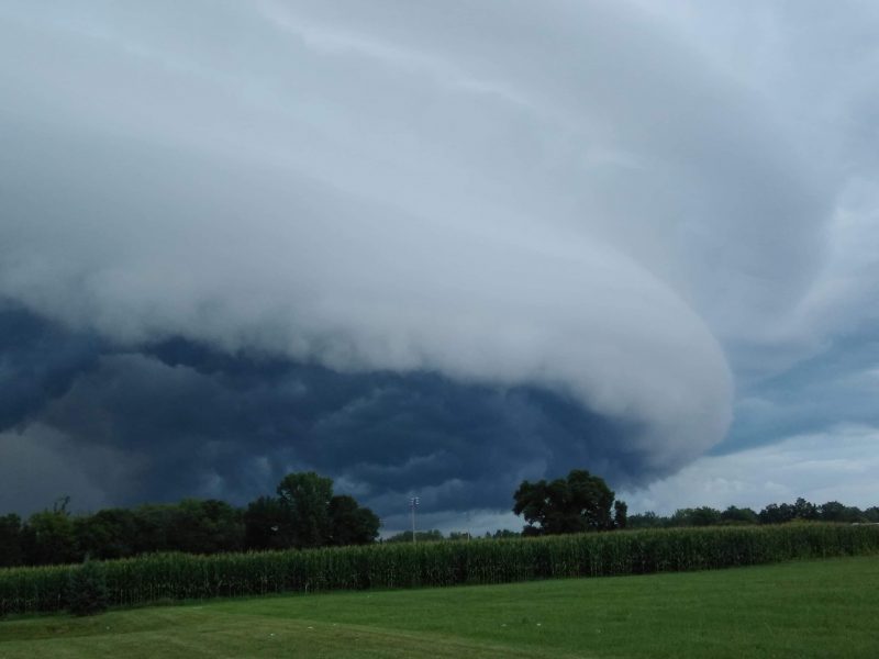
A strong cold front moving across the middle of the United States is forecast to bring the risk of severe weather for millions Friday, Saturday and Sunday. Large hail and damaging wind gusts are the main threats, but isolated tornadoes are also possible. The Storm Prediction Center has already outlined these next three days for possible severe weather. Plus you can go to the National Weather Service and enter your location. This will give you a complete forecast with what to expect over the next seven days.
Severe weather forecast for Friday
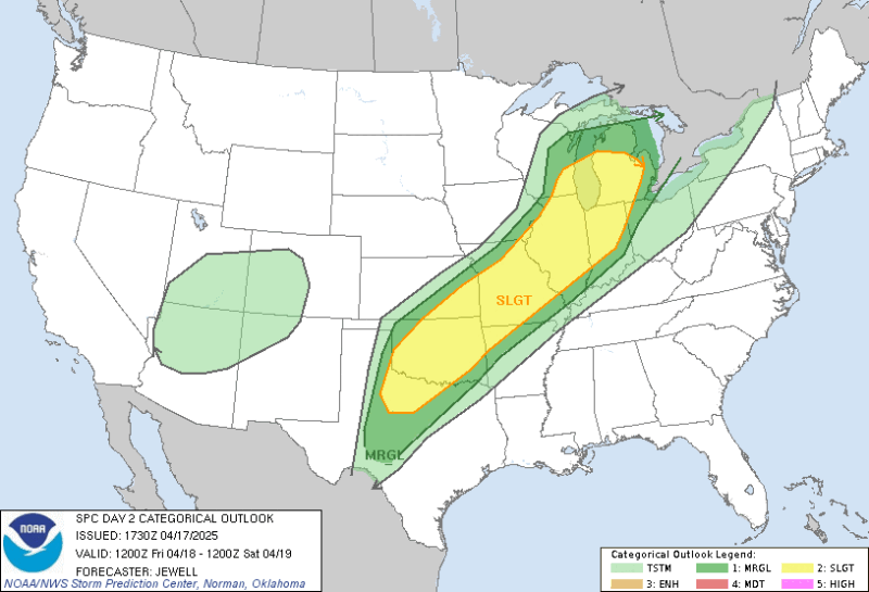
A Slight Risk (level 2 out of 5) for severe weather includes communities from Abilene, Texas through Oklahoma City, Oklahoma, Springfield, Illinois up toward Grand Rapids, Michigan. Warm, moist air will flow north from the Gulf into the middle of the country as a cold front approaches from he west. By Friday evening, thunderstorms with the potential to produce isolated tornadoes, damaging wind gusts and large hail will develop along the front stretching from Texas through the upper Great Lakes. By Friday night, the severe threat moves east.
Forecast for Saturday
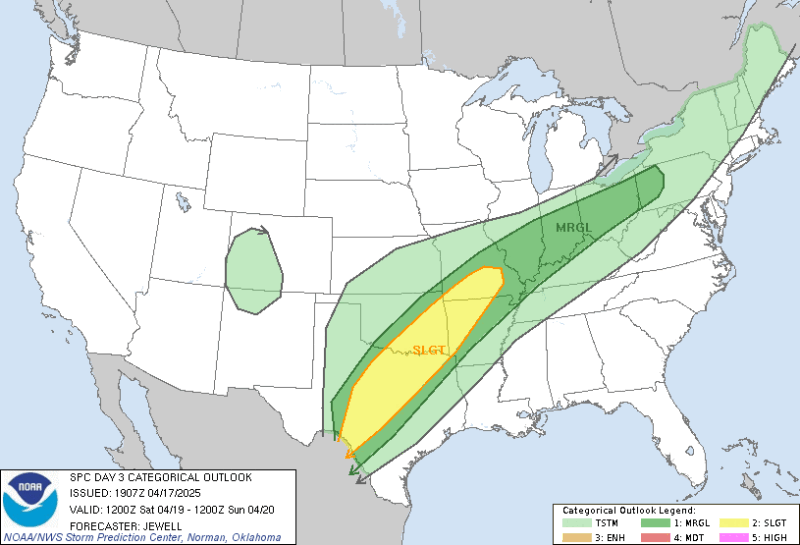
The severe threat for Saturday shifts slightly south from the day before, focused across central Texas into the Ohio Valley region. Once again a Slight Risk (level 2 out of 5) for severe weather is in place. The cold front that will spark the severe weather Friday will stall out across the middle part of the country. This will keep that warm, moist air from the Gulf positioned over Texas, Oklahoma, Arkansas and Missouri. The storms from Friday night will continue into early Saturday morning along that same cold front, but more storms will redevelop during the afternoon during the peak heating of the day. Warm temperatures are vital for thunderstorms development as it provides energy for the storms to tap into and get stronger. These storms will continue through the night, aided by a feature called a low-level jet, which is a narrow jet stream of strong winds roughly 5,000 feet (1,500 meters) above the ground that moves south to north. This low-level jet will continue to fuel thunderstorms overnight (despite the lack of energy from daytime sun) by continuing to bring up that moisture from the Gulf. These storms have the potential for large hail and damaging wind gusts, but also an isolated tornado.
Forecast for Sunday
The risk area for Easter Sunday shifts slightly east from Saturday’s risk, but still mainly includes portions of east Texas and the middle to lower Mississippi Valley. A nearly identical storm set-up that has been in place through the weekend will keep that same warm, moist flow moving north from the Gulf. The stalled out cold front will eventually move back north, while another low pressure system with a cold front and warm front develops in central Texas Sunday morning.
This low pressure will move north through the Plains and into the Great Lakes region during the day Sunday. This will create a warm sector that will provide energy and moisture, important ingredients for storm development. The trailing cold front will be the main “initiating” factor for storms to develop Sunday as it moves through the Mississippi Valley by late morning, with more storms developing through the day, moving from west to east.
Staying safe indoor during severe weather
Spring is a popular time to enjoy the weather outside, and with this weekend being Easter weekend, many people will gather to celebrate the holiday with outdoor services, meals and get togethers. If severe weather impacts your plans, do you know how to stay safe?
Preparation is key! Pay attention to the forecast. Remember, you can go to the National Weather Service and enter your location, for a complete forecast with what to expect over the next seven days.
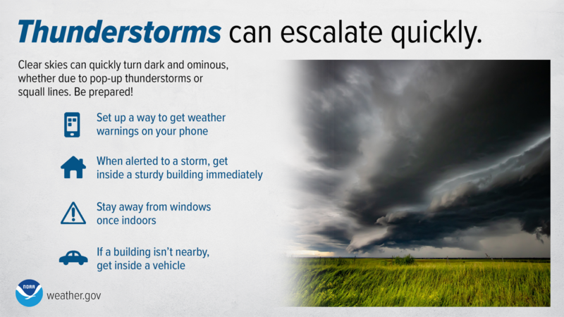
You should also know where to go should severe weather threaten. If you are at a house or building, get inside away from windows as quickly as possible. If you are at a public park, a shelter will protect you from the rain, but. you will still be at risk of damaging wind and lightning, not to mention a tornado. Find an enclosed structure as soon as possible to wait out the storm. If the storm has no threat of a tornado, you can wait it out inside a vehicle, with the doors closed and windows rolled up. But remember: a car is not a safe place to shelter during a tornado.
Also make sure you have a way to receive weather information or warnings. A trusted weather app on your phone that will alert you to the presence of lightning is a great way to stay ahead of developing or approaching storms, as well as get weather watches and warnings issued by your local National Weather Service office. A NOAA Weather Radio is also an important tool to have, as this weather radio will sound when a weather watch or warning is issued. A weather radio is designed to be loud in order to get your attention, or even wake you up in the middle of the night. Having a weather radio on while preparing for, or enjoying an outdoor gathering is a great way to stay aware and safe during a holiday weekend. You can find more information here on how to properly program your NOAA Weather Radio.

Botton line: There’s a severe weather forecast for parts of the central U.S. this Easter weekend. Stay weather aware and know where to take shelter if enjoying the holiday weekend outside.
The post Spotlight on severe weather forecast for central U.S. Easter weekend first appeared on EarthSky.
from EarthSky https://ift.tt/BXGIWdA
A strong cold front moving across the middle of the United States is forecast to bring the risk of severe weather for millions Friday, Saturday and Sunday. Large hail and damaging wind gusts are the main threats, but isolated tornadoes are also possible. The Storm Prediction Center has already outlined these next three days for possible severe weather. Plus you can go to the National Weather Service and enter your location. This will give you a complete forecast with what to expect over the next seven days.
Severe weather forecast for Friday
A Slight Risk (level 2 out of 5) for severe weather includes communities from Abilene, Texas through Oklahoma City, Oklahoma, Springfield, Illinois up toward Grand Rapids, Michigan. Warm, moist air will flow north from the Gulf into the middle of the country as a cold front approaches from he west. By Friday evening, thunderstorms with the potential to produce isolated tornadoes, damaging wind gusts and large hail will develop along the front stretching from Texas through the upper Great Lakes. By Friday night, the severe threat moves east.
Forecast for Saturday
The severe threat for Saturday shifts slightly south from the day before, focused across central Texas into the Ohio Valley region. Once again a Slight Risk (level 2 out of 5) for severe weather is in place. The cold front that will spark the severe weather Friday will stall out across the middle part of the country. This will keep that warm, moist air from the Gulf positioned over Texas, Oklahoma, Arkansas and Missouri. The storms from Friday night will continue into early Saturday morning along that same cold front, but more storms will redevelop during the afternoon during the peak heating of the day. Warm temperatures are vital for thunderstorms development as it provides energy for the storms to tap into and get stronger. These storms will continue through the night, aided by a feature called a low-level jet, which is a narrow jet stream of strong winds roughly 5,000 feet (1,500 meters) above the ground that moves south to north. This low-level jet will continue to fuel thunderstorms overnight (despite the lack of energy from daytime sun) by continuing to bring up that moisture from the Gulf. These storms have the potential for large hail and damaging wind gusts, but also an isolated tornado.
Forecast for Sunday
The risk area for Easter Sunday shifts slightly east from Saturday’s risk, but still mainly includes portions of east Texas and the middle to lower Mississippi Valley. A nearly identical storm set-up that has been in place through the weekend will keep that same warm, moist flow moving north from the Gulf. The stalled out cold front will eventually move back north, while another low pressure system with a cold front and warm front develops in central Texas Sunday morning.
This low pressure will move north through the Plains and into the Great Lakes region during the day Sunday. This will create a warm sector that will provide energy and moisture, important ingredients for storm development. The trailing cold front will be the main “initiating” factor for storms to develop Sunday as it moves through the Mississippi Valley by late morning, with more storms developing through the day, moving from west to east.
Staying safe indoor during severe weather
Spring is a popular time to enjoy the weather outside, and with this weekend being Easter weekend, many people will gather to celebrate the holiday with outdoor services, meals and get togethers. If severe weather impacts your plans, do you know how to stay safe?
Preparation is key! Pay attention to the forecast. Remember, you can go to the National Weather Service and enter your location, for a complete forecast with what to expect over the next seven days.
You should also know where to go should severe weather threaten. If you are at a house or building, get inside away from windows as quickly as possible. If you are at a public park, a shelter will protect you from the rain, but. you will still be at risk of damaging wind and lightning, not to mention a tornado. Find an enclosed structure as soon as possible to wait out the storm. If the storm has no threat of a tornado, you can wait it out inside a vehicle, with the doors closed and windows rolled up. But remember: a car is not a safe place to shelter during a tornado.
Also make sure you have a way to receive weather information or warnings. A trusted weather app on your phone that will alert you to the presence of lightning is a great way to stay ahead of developing or approaching storms, as well as get weather watches and warnings issued by your local National Weather Service office. A NOAA Weather Radio is also an important tool to have, as this weather radio will sound when a weather watch or warning is issued. A weather radio is designed to be loud in order to get your attention, or even wake you up in the middle of the night. Having a weather radio on while preparing for, or enjoying an outdoor gathering is a great way to stay aware and safe during a holiday weekend. You can find more information here on how to properly program your NOAA Weather Radio.
Botton line: There’s a severe weather forecast for parts of the central U.S. this Easter weekend. Stay weather aware and know where to take shelter if enjoying the holiday weekend outside.
The post Spotlight on severe weather forecast for central U.S. Easter weekend first appeared on EarthSky.
from EarthSky https://ift.tt/BXGIWdA