Will you see colors in aurora? Or do you need a camera?

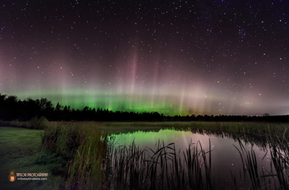
Aurora: Starry night with a field with water underneath. Pale green and pink colors are visible in both the sky and reflection in the water.
Do you see colors in an aurora? Mike Taylor de-saturated some of the colors in this photo – that is, he subtracted the colors via processing – to show what his eye saw at his location. Image via Mike Taylor.

By Mike Taylor of Taylor Photography in Unity, Maine.

Seeing aurora is breathtaking, but what about colors?

While observing the aurora, or northern lights, is a truly awe-inspiring and often breathtaking experience, the images that come out of modern day DSLR cameras may not match what you witness in real life. Or even your cell phone. Especially if you live below about 50 degrees N. latitude, as I do in Unity, Maine.

I’ve photographed many colors in the fantastic northern lights displays. And I’ve been lucky enough to observe many colors: green, purple, yellow, orange, red, magenta and blue. But I never really know what color they are unless I’m looking at my camera’s LCD screen. Or more importantly, viewing these images on my computer.

To my eye, at my latitude, the aurora is typically low on the horizon, and it tends to come in shades of grey. With only a small amount of color, as in the photo above.

Latitude makes a huge difference in aurora

I’ve heard from folks who have visited or lived in areas such as Alaska, Norway or higher northerly latitudes. Where they live, the aurora is usually overhead, not on the horizon. So, the colors of an aurora are easily seen with the unaided eye.

Also, I made the attached graphic (below) to show what I mean. Because these three photographs exemplify the most impressive aurora displays I’ve seen. The skies in the top row of images are de-saturated by color (green, yellow, red, magenta, purple, blue) to show what I saw with my eyes.

A bit of green has been retained on the horizons and just a bit of the color that I remember seeing above that: red, violet and red respectively.
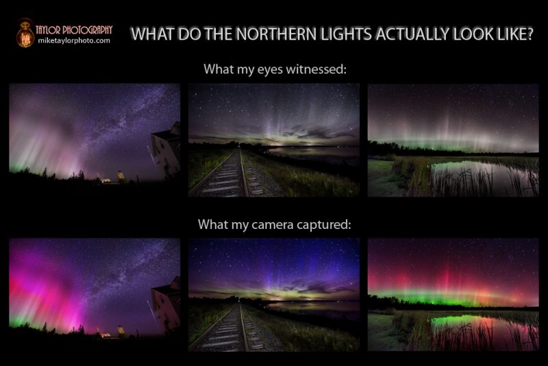
Composition with 3 images at top and 3 at bottom. The top images show grey and pale tones while images at bottom show more colors.
View larger. | A comparison of what the camera sees and what the eye sees. Image via Mike Taylor.

Camera settings for aurora

I generally set the white balance on my camera at Kelvin 3450 to 3570 when shooting the features of the night sky. But I will also take a few frames with it set on auto to see what colors the camera thinks it should be capturing. Most times I end up going with the Kelvin setting, which is a little bit on the cool/blue side of the spectrum.

The EXIF data for these shots are K-3450, K-3570 and K-3570 respectively. I process all my photos through Lightroom 4 & Photoshop CS5 and I certainly have an “artist’s view” when bringing an image to life. However, when it comes to these strong aurora scenes, the colors have not been saturated very much because Mother Nature did that work beautifully.
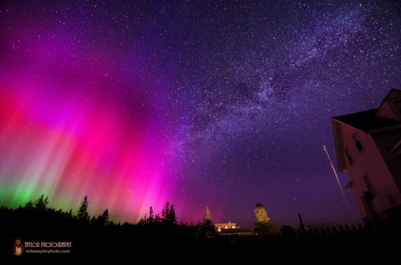
Starry night with vivid colors from an aurora at the left side of the image.
View larger. | What the camera sees. Pemaquid Point Lighthouse. Image via Mike Taylor.

Seeing dancing lights and spikes

I saw “dancing lights” in the sky, spiking straight up starting around 100 feet (30 meters) off the ground. They waved a bit like curtains but stayed in basically the same area. They seemed to be kind of a blur though, and the “spikes” were not very defined. There was definitely a green hue on the horizon and a bit of red color above that. But I didn’t see the crazy red & magenta colors that my camera recorded. I saw what appeared to be white/grey “curtains” dancing along the black sky.

Blue curtains and green at the horizon with train tracks.
View larger. | What the camera sees. Unity Train Tracks. Image via Mike Taylor.

I didn’t see much of anything but I set up, started shooting and immediately saw green on the horizon on my camera screen. I set the camera to shoot 30 second exposures for an hour with just a few seconds in between. So, I could quickly review the scenes on the LCD screen as my camera snapped away.

Within 10 minutes or so, I saw sharp spikes or columns shooting up and slowly moving across the sky. To my eye they appeared to be a light violet/purple color enough that I posted a status update to Facebook at 2:24 am. I said:

You know the aurora is cranked up when you can see the purple spikes with your naked eye.

When the display died down, I quickly looked through my images but I didn’t really know the spikes were blue until I viewed them on my computer.
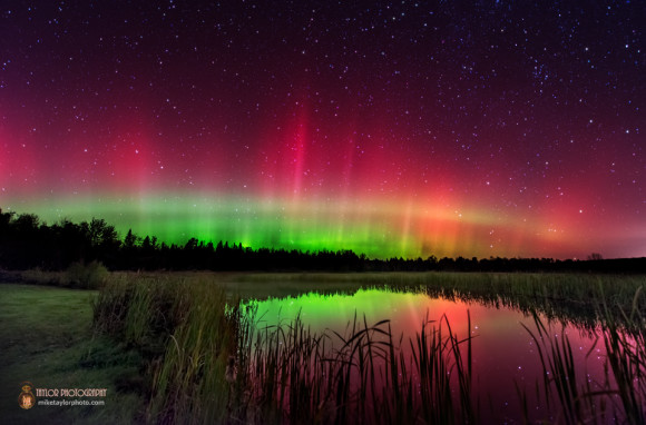
Starry night with a field with water underneath. Vivid green and pink colors are visible in both the sky and reflection in the water.
View Larger. | What the camera sees. Small Pond Outside of Unity. Image via Mike Taylor.

Incredible oval, perfect arc and tall spikes. Oh my!

The most impressive oval I’ve ever seen, a perfect arc which covered the Northern sky’s horizon. The tallest and most crisp “spikes” I’ve witnessed, reaching all the way to the stars. Again, I saw definite green around the oval at the horizon but the spikes themselves were white/grey. And not the intense red that my camera captured.

Aurora displays ebb and flow, constantly changing

The intensity of the aurora always ebbs and flows, sometimes it is quite strong and other times it is mild. If you can see a simple glow or swirling lights on the horizon and/or “spikes” shooting into the sky that look like spotlights and/or “curtains” of light, pay attention and/or be patient. The display can last just a few minutes, a half hour or longer. Most of the intense shows I have witnessed in central and northern Maine have lasted around half an hour.

Why are the colors of the aurora so elusive? The simple answer is that human eyes have difficulty perceiving the relatively “faint” colors of the aurora at night. Our eyes have cones and rods. The cones work mainly during the day and the rods work mainly at night.

Jerry Lodriguss at astropix.com wrote:

Humans use two different kinds of cells in their eyes to sense light. Cone cells, concentrated in the fovea in the central area of vision, are high resolution and detect color in bright light. These are the main cells we use for vision in the daytime. Rod cells, concentrated in the periphery around the outside of the fovea, can detect much fainter light at night, but only see in black and white and shades of gray. [The aurora or northern lights] only appear to us in shades of gray because the light is too faint to be sensed by our color-detecting cone cells.

What you see versus what cameras capture

Thus, the human eye views the northern lights generally in faint colors and as shades of grey and white. While DSLR camera sensors don’t have the same limitation as our eyes. Couple that fact with long exposure times and high ISO settings of modern cameras, and it’s quite evident that the camera sensor has a much higher dynamic range of vision in the dark than we do.

By the way, the same thing is true regarding the Milky Way and night photography in general.

Feel free to share this post if you dig it and if you’ve read all the way down to here, I offer you a sincere thanks. I hope you found this information useful!

Cheers!

Images and article via Mike Taylor and reprinted with permission.

Smiling man with a cap and glasses.
Mike Taylor of Taylor Photography in Unity, Maine.

Bottom line: A camera records more vivid colors in an aurora than you see with the unaided eye. Either way, they are an awesome sight!

Taylor Photography is an imaging studio based in a 19th century farmhouse in central Maine. I have been a scenic & nature photographer and a studio photographer for over 20 years. My recent work in landscape astrophotography has been featured on Space.com, the International Dark Sky Association, Earthsky.org, Spaceweather.com, Accuweather Astronomy and multiple other science pages. I offer night photography & post-processing workshops and I am available for studio/product, architectural and website development photography services. Visit me at:

Taylor Photography

Facebook: https://www.facebook.com/miketaylorphoto

Pinterest: https://pinterest.com/taylorphoto1

Blue aurora, star trails, in Unity, Maine

Also check out EarthSky’s current solar activity

The post Will you see colors in aurora? Or do you need a camera? first appeared on EarthSky.


from EarthSky https://ift.tt/vRdPNso
Aurora: Starry night with a field with water underneath. Pale green and pink colors are visible in both the sky and reflection in the water.
Do you see colors in an aurora? Mike Taylor de-saturated some of the colors in this photo – that is, he subtracted the colors via processing – to show what his eye saw at his location. Image via Mike Taylor.

By Mike Taylor of Taylor Photography in Unity, Maine.

Seeing aurora is breathtaking, but what about colors?

While observing the aurora, or northern lights, is a truly awe-inspiring and often breathtaking experience, the images that come out of modern day DSLR cameras may not match what you witness in real life. Or even your cell phone. Especially if you live below about 50 degrees N. latitude, as I do in Unity, Maine.

I’ve photographed many colors in the fantastic northern lights displays. And I’ve been lucky enough to observe many colors: green, purple, yellow, orange, red, magenta and blue. But I never really know what color they are unless I’m looking at my camera’s LCD screen. Or more importantly, viewing these images on my computer.

To my eye, at my latitude, the aurora is typically low on the horizon, and it tends to come in shades of grey. With only a small amount of color, as in the photo above.

Latitude makes a huge difference in aurora

I’ve heard from folks who have visited or lived in areas such as Alaska, Norway or higher northerly latitudes. Where they live, the aurora is usually overhead, not on the horizon. So, the colors of an aurora are easily seen with the unaided eye.

Also, I made the attached graphic (below) to show what I mean. Because these three photographs exemplify the most impressive aurora displays I’ve seen. The skies in the top row of images are de-saturated by color (green, yellow, red, magenta, purple, blue) to show what I saw with my eyes.

A bit of green has been retained on the horizons and just a bit of the color that I remember seeing above that: red, violet and red respectively.

Composition with 3 images at top and 3 at bottom. The top images show grey and pale tones while images at bottom show more colors.
View larger. | A comparison of what the camera sees and what the eye sees. Image via Mike Taylor.

Camera settings for aurora

I generally set the white balance on my camera at Kelvin 3450 to 3570 when shooting the features of the night sky. But I will also take a few frames with it set on auto to see what colors the camera thinks it should be capturing. Most times I end up going with the Kelvin setting, which is a little bit on the cool/blue side of the spectrum.

The EXIF data for these shots are K-3450, K-3570 and K-3570 respectively. I process all my photos through Lightroom 4 & Photoshop CS5 and I certainly have an “artist’s view” when bringing an image to life. However, when it comes to these strong aurora scenes, the colors have not been saturated very much because Mother Nature did that work beautifully.

Starry night with vivid colors from an aurora at the left side of the image.
View larger. | What the camera sees. Pemaquid Point Lighthouse. Image via Mike Taylor.

Seeing dancing lights and spikes

I saw “dancing lights” in the sky, spiking straight up starting around 100 feet (30 meters) off the ground. They waved a bit like curtains but stayed in basically the same area. They seemed to be kind of a blur though, and the “spikes” were not very defined. There was definitely a green hue on the horizon and a bit of red color above that. But I didn’t see the crazy red & magenta colors that my camera recorded. I saw what appeared to be white/grey “curtains” dancing along the black sky.

Blue curtains and green at the horizon with train tracks.
View larger. | What the camera sees. Unity Train Tracks. Image via Mike Taylor.

I didn’t see much of anything but I set up, started shooting and immediately saw green on the horizon on my camera screen. I set the camera to shoot 30 second exposures for an hour with just a few seconds in between. So, I could quickly review the scenes on the LCD screen as my camera snapped away.

Within 10 minutes or so, I saw sharp spikes or columns shooting up and slowly moving across the sky. To my eye they appeared to be a light violet/purple color enough that I posted a status update to Facebook at 2:24 am. I said:

You know the aurora is cranked up when you can see the purple spikes with your naked eye.

When the display died down, I quickly looked through my images but I didn’t really know the spikes were blue until I viewed them on my computer.

Starry night with a field with water underneath. Vivid green and pink colors are visible in both the sky and reflection in the water.
View Larger. | What the camera sees. Small Pond Outside of Unity. Image via Mike Taylor.

Incredible oval, perfect arc and tall spikes. Oh my!

The most impressive oval I’ve ever seen, a perfect arc which covered the Northern sky’s horizon. The tallest and most crisp “spikes” I’ve witnessed, reaching all the way to the stars. Again, I saw definite green around the oval at the horizon but the spikes themselves were white/grey. And not the intense red that my camera captured.

Aurora displays ebb and flow, constantly changing

The intensity of the aurora always ebbs and flows, sometimes it is quite strong and other times it is mild. If you can see a simple glow or swirling lights on the horizon and/or “spikes” shooting into the sky that look like spotlights and/or “curtains” of light, pay attention and/or be patient. The display can last just a few minutes, a half hour or longer. Most of the intense shows I have witnessed in central and northern Maine have lasted around half an hour.

Why are the colors of the aurora so elusive? The simple answer is that human eyes have difficulty perceiving the relatively “faint” colors of the aurora at night. Our eyes have cones and rods. The cones work mainly during the day and the rods work mainly at night.

Jerry Lodriguss at astropix.com wrote:

Humans use two different kinds of cells in their eyes to sense light. Cone cells, concentrated in the fovea in the central area of vision, are high resolution and detect color in bright light. These are the main cells we use for vision in the daytime. Rod cells, concentrated in the periphery around the outside of the fovea, can detect much fainter light at night, but only see in black and white and shades of gray. [The aurora or northern lights] only appear to us in shades of gray because the light is too faint to be sensed by our color-detecting cone cells.

What you see versus what cameras capture

Thus, the human eye views the northern lights generally in faint colors and as shades of grey and white. While DSLR camera sensors don’t have the same limitation as our eyes. Couple that fact with long exposure times and high ISO settings of modern cameras, and it’s quite evident that the camera sensor has a much higher dynamic range of vision in the dark than we do.

By the way, the same thing is true regarding the Milky Way and night photography in general.

Feel free to share this post if you dig it and if you’ve read all the way down to here, I offer you a sincere thanks. I hope you found this information useful!

Cheers!

Images and article via Mike Taylor and reprinted with permission.

Smiling man with a cap and glasses.
Mike Taylor of Taylor Photography in Unity, Maine.

Bottom line: A camera records more vivid colors in an aurora than you see with the unaided eye. Either way, they are an awesome sight!

Taylor Photography is an imaging studio based in a 19th century farmhouse in central Maine. I have been a scenic & nature photographer and a studio photographer for over 20 years. My recent work in landscape astrophotography has been featured on Space.com, the International Dark Sky Association, Earthsky.org, Spaceweather.com, Accuweather Astronomy and multiple other science pages. I offer night photography & post-processing workshops and I am available for studio/product, architectural and website development photography services. Visit me at:

Taylor Photography

Facebook: https://www.facebook.com/miketaylorphoto

Pinterest: https://pinterest.com/taylorphoto1

Blue aurora, star trails, in Unity, Maine

Also check out EarthSky’s current solar activity

The post Will you see colors in aurora? Or do you need a camera? first appeared on EarthSky.


from EarthSky https://ift.tt/vRdPNso

Exploring Mars’ Grand Canyon with a swarm of robotic drones

exploring Mars' Grand Canyon: Aerial view of large canyon with steep walls and sharp-edged ridges.
View larger. | Perspective view of Tithonium Chasma, part of the massive Valles Marineris canyon system on Mars. Can you imagine a swarm of robotic drones exploring here? That’s a proposed mission concept, from Germany. Image via ESA/ DLR/ FU Berlin (CC BY-SA 3.0 IGO).
  • Valles Marineris is the Grand Canyon of Mars. It’s the largest canyon system in the solar system, 10 times longer, 20 times wider, and five times deeper than the Grand Canyon. If it were on Earth, it would stretch from the U.S. East to West coasts.
  • A swarm of robotic drones has been proposed to drive, walk and fly around the canyon. They could also explore caves in the canyon and look for traces of water.
  • A UFO/UAP camera stationed on the ground would also monitor the sky for clouds, meteors, lightning … or other “unusual activity.”

Exploring Mars’ Grand Canyon

The largest canyon in the solar system is on Mars. Valles Marineris is the Grand Canyon of Mars and dwarfs its counterpart on Earth. Orbiting spacecraft have photographed it in great detail, but no mission has yet visited it on the ground. But that might be about to change. The German Space Agency at the German Aerospace Centre (DLR) in Bonn, Germany, is developing an ambitious mission concept called Valles Marineris Explorer, or VaMEx. It involves a swarm of robotic drones that can drive, walk and fly, the researchers said on September 10, 2024. It would explore the sprawling canyon and caves within it.

Interestingly, the mission would also include a UAP camera, named for Unidentified Anomalous Phenomena. That term has, in recent years, replaced the acronym UFO in government-speak of several nations. It’s been used to describe any unusual phenomena seen in Earth’s atmosphere, or oceans. The UAP camera would be stationary. It would watch Mars’ sky continuously. It would keep an eye out for anything unusual. More about it below.

A robotic swarm for exploring Mars’ Grand Canyon

VaMEx consists of a complex swarm of robotic drones that can both move on the ground and fly in the air. The drones would communicate both with each other and a central gateway station on the surface.

In addition, the drones would look for traces of water that could help support life in protected niches. Indeed, orbiting spacecraft have photographed foggy mists in the canyon. The search for water also includes caves within the canyon. If there is any existing life on Mars today – even if just microbial – the environment deep inside caves would be a good place to look. They might have enough traces of water and would offer protection from the harsh radiation that hits Mars’ surface from the sun. Plus, of course, caves provide a natural doorway to explore geologic formations beneath the surface. What might we find?

Complex communications and drone network

There is a sub-project of VaMEx called VaMEx3-MarsSymphony, or just MarsSymphony. It is developing the complex communications system needed for the swarm. Hakan Kayal at the University of Würzburg is the project leader. He said:

We have given our sub-project the name ‘VaMEx3-MarsSymphony’ because the aim is to make the individual elements of the robot swarm play together harmoniously like an orchestra.

The swarm concept includes the stationary gateway, or command center, to aid communications for the drones. It would also facilitate communication with each other and with orbiting spacecraft and Earth. But sometimes the drones won’t be able to communicate directly with the gateway. For example, when they’re inside caves. To work around this, there would also be repeater stations on the ground. They can pass along recorded images and other data from the drone in the cave to the gateway.

2 cartoon-like diagrams showing a spacecraft over Mars and a mechanical machine on the ground, with text labels.
View larger. | A simplified diagram depicting the VaMEx drone swarm and gateway with UAP camera concept. Image via Clemens Riegler/ University of Würzburg.

Spreading ‘seeds’ on Mars

Another element of the swarm concept is autorotation bodies. These are small “craft” that are simply dropped from the air and gently glide to the ground. They kind of look like maple seeds with their elongated bodies. They also spin as they glide downward, with the aid of a wing. And like seeds being dispersed, they can be distributed over a wide area. They gather data as they fall to the Martian surface.

In addition, they can function as sensors, repeaters and navigation networks. Clemens Riegler is the project manager of MarsSymphony. He said:

It’s great to see that DLR is recognizing this work and that it has now become part of a project to explore Mars!

UAP camera to scan Martian skies

There is another unique element to the VaMEx mission, something else never done before. The researchers want to include a UAP camera, or celestial camera, on the stationary gateway. UAP – Unidentified Anomalous Phenomena – is the term now used by governments and the military for what used to be called UFOs. It’s for sightings of unusual objects or other phenomena in Earth’s atmosphere (and now including the ocean or space as well).

In the case of VaMEx, the UAP camera would watch the Martian sky continuously. That would be its only function. While not specifically looking for alien spacecraft, it would monitor clouds, meteors, lightning or any other unusual or short-lived phenomena. No other lander or rover mission has done that before. They have coincidentally imaged the Martian sky and even the moons Phobos and Deimos, for example. But the sole purpose of this camera would be to stare at the sky. As Kayal said:

All previous Mars missions have focused on the surface of the planet, but we want to look upward for the first time.

Reddish planet with dark spots and patches, thin clouds and long canyon stretching across the middle.
View larger. | Mosaic composed of 102 Viking orbiter images of Mars. Valles Marineris is the long gash across the center of the image. Image via NASA/ JPL-Caltech.

What is the UAP camera looking for?

You can also read a more detailed interview with Hakan Kayal where he explains how the UAP camera would work. As Kayal told researcher Andreas Müller in Germany:

We still don’t know what UFOs and UAPs are. Mars and Earth are very similar in many ways, from geology to meteorology. If there are UAPs on Earth, they could also be visible in the Martian sky. Another advantage of such a detection would be that on Mars we could at least rule out known terrestrial triggers of many classic UFO/UAP sightings such as birds, insects, balloons and aeroplanes etc. as explanations for any UAPs detected from the outset. The number of terrestrial satellites and probes on and around Mars is also still manageable and their flight and orbital paths are known, predictable and easy to check.

However, we are not looking for little green men on Mars, but anomalies that could indicate new events or characteristics. The chances of this are small, but such a detection on Mars would be a sensation and would provide us with data that often stand in the way of clarifying these phenomena with terrestrial systems.

Bottom line: Researchers in Germany are developing a mission for exploring Mars’ Grand Canyon, Valles Marineris. It would involve a swarm of robotic drones.

Via University of Würzburg

Read more: See Mars’ Grand Canyon in stunning new photos

Read more: Scientists find water in Mars’ Grand Canyon

The post Exploring Mars’ Grand Canyon with a swarm of robotic drones first appeared on EarthSky.


from EarthSky https://ift.tt/9GrIqtL

Octans and Apus circle the south celestial pole

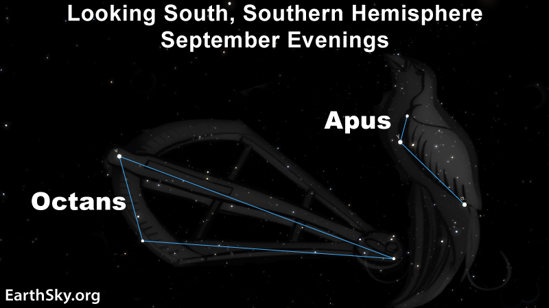
Star chart showing 2 dim constellations and their outlines, Octans and Apus.
Octans and Apus (the Octant and the Bird of Paradise, respectively) lie far south. In fact, Octans is home to the south celestial pole. Be sure to look for them from the Southern Hemisphere on September evenings. Chart via EarthSky.

Octans and Apus

Octans the Octant and Apus the Bird of Paradise circle the south celestial pole. If you want to see them, you’ll have to be in the Southern Hemisphere. In fact, the south celestial pole lies inside the constellation boundary for Octans.

Both of these constellations are south circumpolar constellations. Of course, the north has circumpolar constellations too. Constellations such as Ursa Minor, Ursa Major and Draco can be seen any night of the year from the Northern Hemisphere. Octans and Apus are two constellations that Southern Hemisphere observers can view on any clear evening.

Octans the Octant

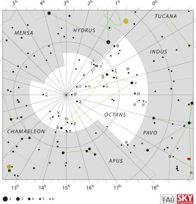
Furthermore, the most important fact about Octans is that it contains the south celestial pole. While the Northern Hemisphere has Polaris marking the location of the north celestial pole, the Southern Hemisphere has no bright star to mark its celestial pole. However, there is an extremely dim galaxy that is nearly at the location of the south celestial pole. And that galaxy has the fitting name of Polarissima Australis. It shines at magnitude 13.5.

The brightest star in Octans is a middling magnitude 3.73: Nu Octantis. It lies 69 light-years away. The star may be home to a super-Jovian exoplanet.

White chart with black dots for stars outlining the shape of Octans.
Star chart for Octans the Octant. The location where all the lines converge marks the south celestial pole. Chart via IAU/ Sky and Telescope/ Wikimedia Commons.

Apus the Bird of Paradise

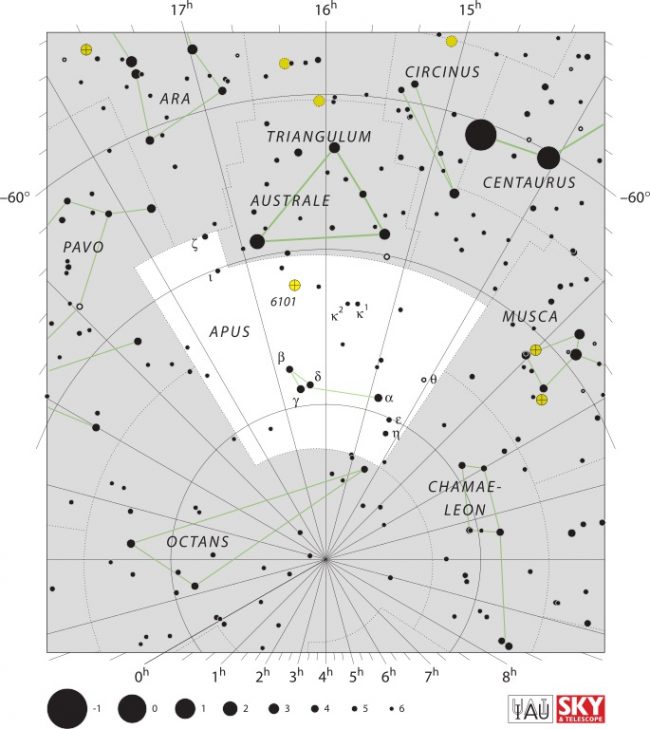
Then, next to Octans, is Apus the Bird of Paradise. It’s small and ranked 67th in size out of the 88 constellations. It lies between Octans and Triangulum Australe the Southern Triangle. The stars in Apus are quite dim. The brightest member of the constellation is Alpha Apodis at magnitude 3.83. Alpha Apodis lies about 430 light-years from Earth. Slightly fainter is Gamma Apodis at magnitude 3.86 and 150 light-years distant. This star is a strong source of X-rays.

White chart with black dots for stars showing Apus.
Star chart for Apus the Bird of Paradise. Chart via IAU/ Sky and Telescope/ Wikimedia Commons.

Bottom line: Octans and Apus are two constellations that you have to be in the Southern Hemisphere to see. Plus, Octans is home to the south celestial pole.

The post Octans and Apus circle the south celestial pole first appeared on EarthSky.


from EarthSky https://ift.tt/JFNidCU

Tropical Storm Helene to strengthen and hit Florida

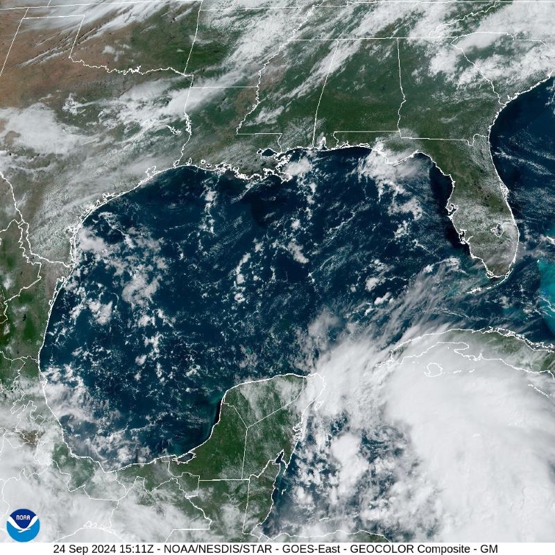
Hurricane Helene: Satellite view of the Gulf of Mexico showing dense clouds off the coast of the Yucatan.
This was the view of Tropical Storm Helene in the Caribbean Sea on September 24, 2024. Forecasters expect it to strengthen into Hurricane Helene as it moves into the Gulf of Mexico. It should hit Florida around the Big Bend region on Thursday as a major hurricane. Image via NOAA/ GOES-East.

Hurricane Helene to form and hit Florida

On Tuesday morning, the storm system in the Caribbean Sea strengthened into Tropical Storm Helene. The National Weather Service says it will continue to rapidly strengthen, becoming a hurricane on Wednesday. Helene will brush past Key West, Florida, on Wednesday night as a hurricane. Forecasters believe it will strengthen into a major hurricane, with winds above 111 miles per hour (as a Category 3) before hitting the Big Bend area of Florida on Thursday.

Even before the storm comes ashore, forecasters expect the storm to widen, with people along the west coast of Florida feeling the impact of the storm’s outer bands on Wednesday.

Showing dangerous potential

There are four stages to the development of a tropical cyclone. They start with a tropical disturbance and then progress to a tropical depression, tropical storm and then finally a hurricane if the winds reach 74 miles per hour or more.

Helene began making news while it was still in the stage of a potential tropical cyclone, even before becoming a named storm. The National Weather Service uses this term for weather systems that pose a threat to land within 48 hours. Part of what will fuel the hurricane is that the waters of the Gulf of Mexico are extremely warm. The region is experiencing record temperatures this year.

This disturbed area started forming in the Caribbean Sea between Jamaica and the Yucatan Peninsula. Its track takes it between the waters of Yucatan and Cuba. In this region it should strengthen to hurricane force. It should then head toward the Big Bend in Florida, becoming a major hurricane before it hits.

Stay updated on this storm system as it strengthens and moves closer to land.

Bottom line: Tropical Storm Helene will rapidly strengthen into a major hurricane (Category 3) before hitting Florida on Thursday.

Read more: 2024 list of Atlantic hurricane names

The post Tropical Storm Helene to strengthen and hit Florida first appeared on EarthSky.


from EarthSky https://ift.tt/mzIR7SJ

SKA telescope gets its ‘1st fringes’

Two diagrams side by side showing SKA telescope observation. Left shows wavy diagonal stripes in colors ranging from green via yellow to purple. Right: grey background with black, purple, orange and red wavy lines.
Here are the so-called “1st fringes” from 2 stations – each consisting of 256 antennas – in the part of the SKA telescope being built in Australia. The “1st fringes” for a radio telescope such as SKA is like 1st light for an optical telescope. It’s a new telescope’s 1st observation. What you see in these images is an interference pattern signal, as 2 of the SKA-Low stations peer toward the giant radio galaxy Centaurus A. Image via SKA Observatory.
  • The SKA Observatory, an Earth-spanning radio observatory, is currently being built at two sites. One site is in South Africa (SKA-Mid), the other is in Australia (SKA-Low).
  • The Australia site successfully connected two of its finished “stations” (256 radio telescopes each) to observe together for the first time, SKAO reported on September 17, 2024.
  • These so-called “first fringes” are a large milestone in a radio telescope’s life and work. They’re equivalent to an optical observatory’s “first light.”

1st “light” for SKA telescope

Radio astronomers are thrilled about the Square Kilometer Array (SKA) telescopes, currently under construction at two sites, one in Australia and one in South Africa. The South Africa site will host 197 dish-type antennas. The Australian site (SKA-Low) has a different type of antenna, measuring at lower wavelengths. SKA-Low will ultimately have 131,072 antennas, divided into 512 “stations.” On September 17, 2024, the SKA-Low reported its first interferometric observations – a technique using the interference of radio waves to extract information – between two of its stations. This observation is that site’s so-called “first fringes,” equivalent to an optical telescope’s first light.

Indeed, it’s such a momentous event in the life of a radio telescope that SKA Observatory director-general Philip Diamond said:

This is the day that the SKA Observatory as a scientific facility was born.

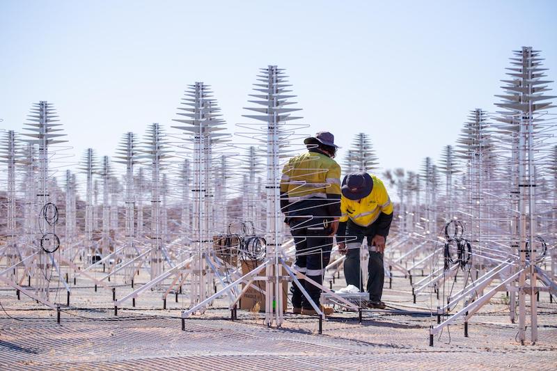
Many tall silvery antennas, each vertical with many branches in a conical shape, with two people.
The SKA-Low antennas in Australia resemble silvery Christmas trees and measure at longer wavelengths than the more familiar dish-style antennas in South Africa. They are collected in circular stations harboring 512 antennas each. On September 17, 2024, 2 such stations observed together, successfully forming an interferometer – a telescope of several connected antennas – for the first time. Image via SKAO.

Light or fringes, the 1st images of a new instrument

Maybe you know that radio waves – at the far end of the electromagnetic spectrum – are longer than waves of visible light? That’s why radio astronomy benefits from very long baselines … long distances between coordinating antennas. The greater the distance between antennas, the more clearly the telescope can “see” in radio. And the more antennas, the more sensitive the telescopes are to faint signals. Since the 1990s, astronomers have been picturing and planning an extremely big and transformative radio interferometer, an observatory consisting of many and distant antennas. SKA is the answer to that long-held vision.

Radio telescopes like SKA don’t typically have a first-light image, as is common for optical telescopes. The concept of “first light” isn’t the same for radio telescopes, as their construction and first use is more incremental.

But when two (or more) radio antennas – or stations of antennas as in the case of SKA-Low – are observing together for the first time, radio astronomers call this “first fringes” instead of first light. This name refers to the wavy signal that varies in time and frequency, correlated between the antennas in the telescope when they first observe together.

A SKA telescope milestone

George Heald, SKA-Low Lead Commissioning Scientist, explained why radio astronomers are especially excited about this achievement:

Finding a strong correlated signal between our first two SKA-Low stations means that the instrument can now function as a radio interferometer. This is an incredible milestone, one that has been achieved by the work of hundreds of people over many years. Many astronomers, including myself, are so excited for what comes next as this telescope continues to scale.

But for a radio observatory, there is not just one milestone before the observatory is fully ready for use. The SKA-Low first fringes come roughly half a year after the first antennas were installed at Inyarrimanha Ilgari Bundara, the CSIRO Murchison Radio-astronomy Observatory (this is the full name of SKA-Low), in March 2024. In August this year, the first image from a single SKA-Low station was released, in a 24-hour observation of the southern sky.


The first SKA-Low station image was a 24-hour observation of the southern sky. It shows our Milky Way galaxy moving across the sky (as the Earth rotates). The annotated radio sources are other galaxies, and during the day, the sun is visible. One of the benefits of radio is that you can also observe during daytime. Video via SKAO.

Meanwhile, in South Africa

The South African site in Karoo has its own milestones. The assembly of the first actual dish of SKA-Mid took place on July 4, 2024. But on January 25, 2023, the SKA Observatory reported that its prototype telescope at Karoo – called SKAMPI – achieved first light with an image of the southern sky in radio.

Actual interferometry “first fringes” are yet to arrive for this part of the observatory, unless you count MeerKAT, which has been up and running for many years already and is going to be incorporated into the SKA-Mid.

You can see how it is not easy to pinpoint an actual “first light” moment for a radio observatory, with all the intricacies in its construction going on!

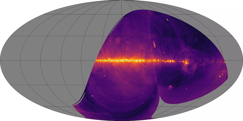
SKA telescope: Gray oval with grid lines and a horizontal yellow-orange streak partway across it.
A prototype antenna for the giant SKA telescope array has released this 1st light image. It’s aimed toward the southern sky in the 2.5 GHz part of the radio end of the electromagnetic spectrum. The full oval (including the gray part) is the complete sky with the Milky Way galactic center in the middle. The radio emission to the right shows the part of the sky – featuring our Milky Way galaxy as a bright line – that the telescope can observe from South Africa. Image via the prototype (SKAMPI) team/ SKAO.

Radio astronomy arrays get better resolution

In radio astronomy, combining many telescopes into an interferometric array increases the resolution. In short, the larger the telescope, the better the resolution, but practical constraints make it impossible to build a single dish that large. The Chinese FAST is currently the world’s largest single-dish telescope at 500 meters (1640 feet). An array has the resolution of a virtual telescope as large as the longest distance between the antennas. In the case of SKAO, this translates to one telescope dish 150 km (93 miles) in diameter, instead of the 15 m (50 feet) of each individual antenna.

Three decades of planning into fruition

The Square Kilometre Array idea was first conceived in the early 1990s. It evolved into an intergovernmental organisation in 2021 – the 2nd astronomical one after European Southern Observatory (ESO) – and currently consists of nine member countries. In December 2022, SKAO held groundbreaking ceremonies at both of its observatory sites and started the construction in earnest.

A first light image of the full observatory will likely be hard to pinpoint, as the antennas will start being used as they are constructed. But, if the science from MeerKAT, the precursor observatory located at the same site, is an indication, we can likely expect some exceptional science to drop in as this radio facility keeps increasing in size. By the way, the 64 MeerKAT antennas will be incorporated into the final SKA, and SKAMPI is contributing to the development of the rest of the antennas.

Two sites with different SKA telescope antennas

Why build such a large observatory? What can we expect radio waves to reveal that we can’t see in, say, infrared with the Webb? The 197 antennas in South Africa, called the SKA-Mid, will observe from 350 MHz to 15.4 GHz in frequency. The Australian portion of the observatory, SKA-Low, will, as the name implies, observe at lower frequencies, from 50-350 MHz. Together, they will have a large collecting area, increasing the sensitivity by 10-100 times that of current observatories. The Australian telescopes are quite different in structure and looks. They are dipole antennas that mostly resemble Christmas trees and there will be roughly 131,000 of them, collected in 512 stations.

Science goals

In terms of science, this translates to being able to reach as far back as to the epoch of reionization, when stars and galaxies started forming. Only radio telescopes can measure neutral hydrogen far out in space, and, with the new ability to measure faint signals, can trace this building block of matter to before stars ionized the gas in the early universe.

And there are many more goals. The telescopes will better chart galaxy evolution, dark matter, and how the strength of dark energy has grown over time. They will monitor gravitational waves via observations of fluctuations in pulsar emission. SETI scientists will listen for faint signals indicating advanced life, while other exoplanet scientists will scrutinize the birth of stars and planets.

Other mysteries we want to learn (much) more about include black holes and fast radio bursts, not to forget more “local” astronomy where, for example, the telescopes trace neutral hydrogen gas in our own galaxy. There is a lot more to discover at home as well! But maybe the most exciting discoveries to come are the ones we do not know about yet. They can be expected, because for every new instrument that comes into use there have been surprises.

Bottom line: SKA-Low, the Australian part of the two SKA telescopes making up the SKA Observatory, successfully measured a correlated signal using two of its stations. Radio astronomers call such a measurement “first fringes” and it is a milestone in the construction of the new radio observatory.

Via SKAO

The post SKA telescope gets its ‘1st fringes’ first appeared on EarthSky.


from EarthSky https://ift.tt/9Gm63eJ

Is there a threat of landslides where you live? See the map

Threat of landslides: Map of the US with shadings from white to yellow to red. Flat areas are white.
Click here to view as an interactive map. This map of the United States shows areas susceptible to landslides. The threat of landslides is higher in the red regions, lower in yellow regions and negligible in white regions. Image via USGS.

Threat of landslides shown in new map

Some 85 million people go to sleep at night in areas prone to landslides. And 75 million Americans spend their days in landslide-prone areas. That’s according to a new study the U.S. Geological Survey released on September 11, 2024. California has the greatest number of people at risk. But West Virginia and Puerto Rico have the highest proportion of people at risk. Not surprisingly, the highest threat of landslides is in mountainous terrain, but nearly 44% of the U.S. could potentially experience landslide activity. As the press release said:

… there is also considerable potential scattered throughout other areas of the country.

The researchers published their study on September 11, 2024, in the peer-reviewed journal AGU Advances.

Mapping the threat of landslides

Previous maps only showed areas that had the highest threat of landslides. The new map extends the range to other areas also at risk. In fact, the map has a county-by-county assessment of landslide dangers. This level of detail is useful for urban planners, engineers, emergency managers, homeowners and more. Click here to take a deeper look at the threats in the United States.

Lead author Ben Mirus, a USGS research geologist, said:

This new national landslide susceptibility map addresses an important but difficult question: which areas across the entire U.S. are prone to landslides? We are excited that it is now publicly available to help everyone be more prepared to be a more hazard-ready nation.

Sign warning of landslides along a coast with water below.
This sign in Cannon Beach, Oregon, warns visitors of the danger of landslides. Image via Marck Roache/ Pexels.

How they created the map

The press release said the team:

… used an inventory of nearly 1 million previous landslides, high-resolution national elevation data from the USGS 3D Elevation Program, and advanced computing to build their comprehensive landslide susceptibility model.

Earlier maps had less detail and neglected landscape that was more moderately sloping. But the report said this is where most development and infrastructure are located.

The team used higher-resolution data, resulting in a map that shows details down to 90 meters, as compared to the previous detail of 1 kilometer. The red areas are most susceptible to landslide, with yellow less so, and white considered with negligible risk.

What exactly are landslides?

The USGS says:

A landslide is defined as the movement of a mass of rock, debris, or earth down a slope.

The term landslide includes five different types of movement: falls, topples, slides, spreads and flows. These would include things such as rockfalls and mudslides.

Landslides are usually the result of multiple causes:

Landslides can be initiated in slopes already on the verge of movement by rainfall, snowmelt, changes in water level, stream erosion, changes in ground water, earthquakes, volcanic activity, disturbance by human activities, or any combination of these factors. Earthquake shaking and other factors can also induce landslides underwater. These landslides are called submarine landslides. Submarine landslides sometimes cause tsunamis that damage coastal areas.

Read more: Landslide-triggered tsunamis becoming more common

Bottom line: A new map from the USGS shows what areas of the United States are susceptible to landslides. See the map and read more about landslides.

Source: Parsimonious High-Resolution Landslide Susceptibility Modeling at Continental Scales

Via USGS

The post Is there a threat of landslides where you live? See the map first appeared on EarthSky.


from EarthSky https://ift.tt/9pOPVXn

2024 September equinox: All you need to know


Happy equinox! We celebrate the September equinox as the first day of autumn for the Northern Hemisphere, and the first day of spring for the Southern Hemisphere. Watch a video about the September equinox, above.

The September equinox is a seasonal milestone in Earth’s yearly orbit around the sun. At an equinox, the sun appears directly above Earth’s equator. At the September equinox, the sun is moving from north to south as it crosses above the equator. It’s bringing summer to the Southern Hemisphere and winter to the Northern Hemisphere.

The 2024 September equinox will fall at 12:44 UTC (7:44 a.m. CDT) on September 22, 2024. On this day, days and nights are approximately (but not exactly) equal in length for everyone across the globe. The word equinox comes from the Latin aequus (equal) and nox (night), that is, equal night.

Keep reading to learn more about this important day.

Drawing of a yellow sun in space, with an ova shape around it (an orbital path). Two titled Earths are located opposite each other on the orbital path.
Happy equinox! This artist’s concept of the September and March equinoxes isn’t to scale. But it illustrates the fact that every equinox is a milestone in Earth’s orbit around the sun. And it shows that, at the equinoxes, Earth’s Northern and Southern Hemispheres receive nearly equal amounts of daylight. Image via NASA/ GSFC/ Genna Duberstein.

Earth’s tilt causes it

The earliest humans spent more time outside than we do. They used the sky as both a clock and a calendar. And they could easily see that the sun’s path across the sky, the length of daylight and the location of the sunrise and sunset all shift in a regular way throughout the year.

The equinoxes and solstices happen because Earth tilts on its axis by 23 1/2 degrees. Because of the Earth’s tilt, the Northern and Southern Hemispheres trade places in receiving the sun’s light and warmth most directly. The solstices indicate our greatest (or least) tilt toward the sun, in either hemisphere. The equinoxes fall midway between the solstices.

Earth’s two hemispheres receive the sun’s rays about equally around equinox time. But Earth never stops moving in orbit around the sun. And these days of approximately equal daylight and night will change quickly as we move toward the December solstice. Maybe you’ve noticed that? The length of daylight changes more quickly from day to day around the equinoxes than around the time of the solstices.

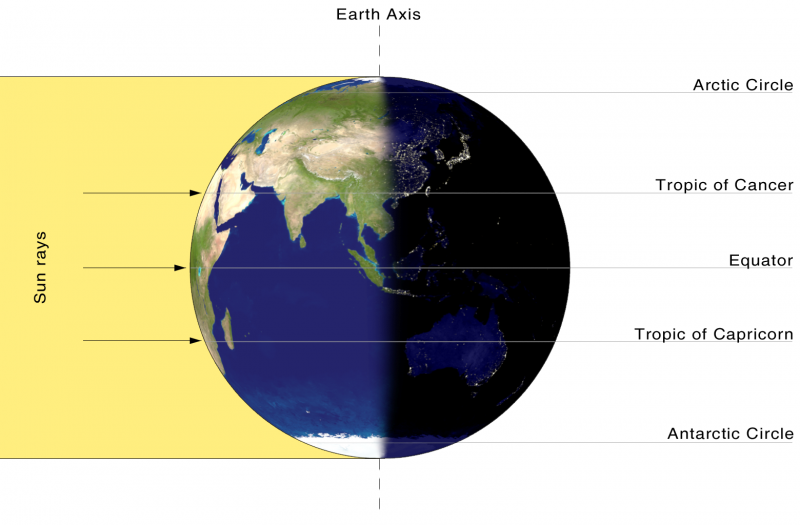
September equinox: Earth perfectly upright with vertical axis, left half sunlit, right half in shadow.
Around the time of an equinox, Earth’s Northern and Southern Hemispheres are receiving the sun’s rays equally. However, that doesn’t mean that day and night are exactly equal in length. In fact, 2 factors cause more day than night during an equinox. Image via Wikipedia (CC BY-SA 2.0).

A good day to find due east and due west

The day of an equinox is a good day for finding the directions due east and due west from your favorite place to watch the sky. The sun rises due east and sets due west at the equinoxes. It’s true no matter where you live on Earth. Why? Because we all see the same sky.

Everywhere on Earth, except at the North and South Poles, you have a due east and due west point on your horizon. And each point marks the intersection of your horizon with the celestial equator, the imaginary line above the true equator of the Earth.

At the equinoxes, the sun appears overhead at local solar noon as seen from Earth’s equator, as the illustration below shows. The sun is on the celestial equator. The celestial equator intersects due east and due west for everyone around the globe. So the sun rises and sets due east and due west at the equinox.

So go outside around sunset or sunrise on the day of an equinox. Notice the location of the sun on the horizon with respect to familiar landmarks. If you do this, you’ll be able to use those landmarks to find those cardinal directions in the weeks and months ahead, long after Earth has moved on in its ceaseless orbit around the sun.

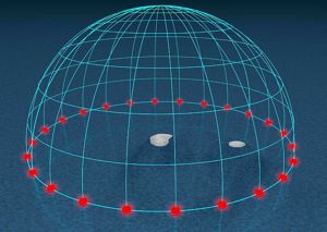
Equinox sun: Diagram of dome with lines of latitude and longitude and red dots around base.
Illustration of the sun’s location on the celestial equator, every hour, on the day of an equinox, via Tau’olunga/ Wikimedia Commons (CC BY-SA 2.5).

Signs of the September equinox in nature

The signs that summer is gone – and winter is coming – are everywhere now on the northern half of Earth’s globe. In the Northern Hemisphere, dawn comes later, and sunset earlier. Also, notice the arc of the sun across the sky. It’s shifting southward now. And birds and butterflies are migrating south, along with the path of the sun.

The shorter days are bringing cooler weather. A chill is in the air. In New York City and other fashionable places, some people have stopped wearing white. Creatures of the wild are putting on their winter coats.

All around us, trees and plants are ending this year’s cycle of growth. Perhaps they’re responding with glorious autumn leaves, or a last burst of bloom before winter comes.

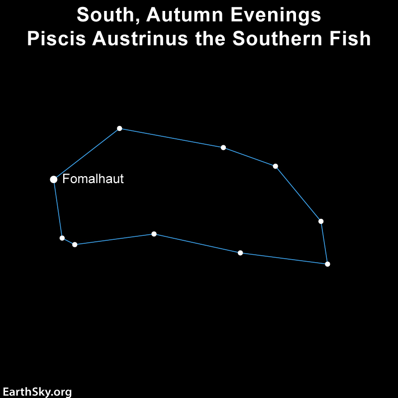
In the night sky, Fomalhaut – our Autumn Star – is making its way across the heavens each night.

Guy Ottewell chart of eclipse night - September 17-18, 2024 - showing both Saturn and Fomalhaut.
In most years, around the September equinox, we point out the bright star Fomalhaut. This star typically appears bright and solitary in the southern sky in autumn, as seen from northern part of the globe. From our part of the world, Fomalhaut is sometimes called the Autumn Star. But in 2024, Fomalhaut isn’t alone. The planet Saturn is near it! Watch for the twin beacons of Fomalhaut and Saturn in the evening sky around the equinox. This chart also shows the location of the eclipsed moon – near this planet, and this star – on the night of September 17-18, 2024. Chart via Guy Ottewell’s blog.
Star chart outlining a blob-like shape with 1 star, Fomalhaut, labeled.
Here’s Fomalhaut’s constellation Piscis Austrinus the Southern Fish. When you look towards this part of the sky, you’re looking out our galaxy’s south window, into intergalactic space. Fomalhaut is bright! But the rest of the stars of Piscis Austrinus are tough to see without a dark sky. Chart via EarthSky.

September equinox images from EarthSky’s community

Autumn trees in the distance, reflecting in a body of water with a log laying across the lake.
Paul C. Peh captured this image in New York on October 23, 2022, and wrote: “This photo was taken during our vacation in the late fall around the Hudson Valley. The foliage and the scenery were simply beautiful beyond words. We found the fall colors, and it was way better than we had expected. Happy Autumnal Equinox Day, everyone!” Thank you, Paul!
Series of sunrises and sunsets on the September equinox.
View at EarthSky Community Photos. | Peter Lowenstein captured these images and wrote: “Equinox sunsets before and after equinox sunrise on 23 September. The instant of the Southern Hemisphere spring equinox in 2023 was at 6.50 UTC on 23 September. This means it was possible to record two equinox sunsets one on the 22nd a few hours before and another a few hours after the equinox sunrise on the 23rd. These are shown in the accompanying composite of three 9 video frame montages.” Thank you, Peter!
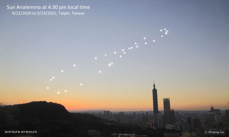
29 photos of the sun creating an infinity symbol shape over a cityscape in twilight.
View at EarthSky Community Photos. | Meiying Lee in Taipei, Taiwan, captured this solar analemma showing the sun’s path over a year, from equinox to equinox, and wrote: “This sun analemma photo of Taipei is composed … by stacking 30 images taken at 4:30 p.m. on different days with a sun filter. They were shot from September 22, 2020, to September 23, 2021, from the same viewing platform on an eastern hill of Taipei. The foreground is the city view of Taipei as seen at the location, with the tallest building being Taipei 101, a famous Taipei landmark.” Thank you, Mei-Ying!

Equinoxes and Earth’s seasons

Seasons diagram.
The tilt of the Earth’s axis affects the amount of sunlight we each receive, on our various locations on the globe, as Earth travels around the sun. At the equinoxes, the sun in shining most evenly across Earth. Image via NASA.

Bottom line: The September equinox is here! It’ll arrive at 12:44 UTC on September 22, 2024. The sun will be exactly above Earth’s equator, moving from north to south. Autumn for the Northern Hemisphere. Spring for the Southern Hemisphere. Here’s all you need to know.

Read: Year’s fastest sunsets at equinox

Read more: Equinox shadows trace a straight line from west to east

The post 2024 September equinox: All you need to know first appeared on EarthSky.


from EarthSky https://ift.tt/WBIyLjC