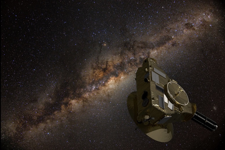
New Horizons measures the darkness of deep space

New Horizons: A spacecraft in the foreground with an image of the Milky Way galaxy behind.
New Horizons, the mission that swept past Pluto in 2015 and then into the deep outer solar system, has now measured the background light of the universe. Artist’s concept via NASA.
  • The one-and-only earthly craft ever to visit Pluto – New Horizons – is now far beyond our solar system’s planets. It’s more than 5.4 billion miles from Earth, headed toward interstellar space.
  • Its view isn’t much obscured now, either by sunlight or by interplanetary dust scattering the light of the stars. That’s why scientists used New Horizons to measure the darkness of space.
  • The measurement revealed that the universe’s distant light is completely due to galaxies. “Looking outside the galaxies, we find darkness there and nothing more,” the researchers said.

NASA published this article on August 28, 2024. Edits by EarthSky.

New Horizons measures background light in the universe

Just how dark is deep space? Astronomers may have finally answered this long-standing question by tapping into the capabilities and present location of NASA’s New Horizons spacecraft. This is the same craft that visited the dwaf planet Pluto in 2015. NASA said on August 28 that it used New Horizons to make:

… the most precise, direct measurements ever of the total amount of light the universe generates.

More than 18 years after its launch from Earth, and nine years after its historic exploration of Pluto, New Horizons is more than 5.4 billion miles (7.3 billion km) from Earth. It’s in a region of the solar system far enough from the sun to offer the darkest skies available to any existing telescope. And its location provides a unique vantage point from which to measure the overall brightness of the distant universe.

Marc Postman is an astronomer at the Space Telescope Science Institute in Baltimore and lead author of a new paper detailing the research, which published August 28, 2024, in the peer-reviewed The Astrophysical Journal. Postman remarked:

If you hold up your hand in deep space, how much light does the universe shine on it? We now have a good idea of just how dark space really is. The results show that the great majority of visible light we receive from the universe was generated in galaxies. Importantly, we also found that there is no evidence for significant levels of light produced by sources not presently known to astronomers.

Our dark universe

The findings solve a puzzle that has perplexed scientists since the 1960s. That’s when astronomers Arno Penzias and Robert Wilson discovered space is pervaded by strong microwave radiation, which had been predicted to be left over from the creation of the universe itself. This result led to them winning the Nobel Prize. Subsequently, astronomers also found evidence of backgrounds of X-rays, gamma rays and infrared radiation that also fill the sky.

Detecting the background of “ordinary” (or visible) light – more formally called the cosmic optical background, or COB – provided a way to add up all the light generated by galaxies over the lifetime of the universe before NASA’s Hubble Space Telescope and James Webb Space Telescope could see the faint background galaxies directly.

In the Hubble and James Webb telescope era, astronomers measure the COB to detect light that might come from sources other than these known galaxies. But measuring the total light output of the universe is extremely difficult from Earth or anywhere in the inner solar system.

Tod Lauer is a New Horizons co-investigator and astronomer from the National Science Foundation NOIRLab in Tucson, Arizona. He is a co-author of the new paper. Lauer said:

People have tried over and over to measure it directly, but in our part of the solar system, there’s just too much sunlight and reflected interplanetary dust that scatters the light around into a hazy fog that obscures the faint light from the distant universe. All attempts to measure the strength of the COB from the inner solar system suffer from large uncertainties.

A job for New Horizons

Enter New Horizons, billions of miles along its trek beyond the planets, now deep in the Kuiper Belt and headed toward interstellar space. Late last summer, from a distance 57 times farther from the sun than Earth, New Horizons scanned the universe with its Long Range Reconnaissance Imager (LORRI), collecting two-dozen separate imaging fields. LORRI itself was intentionally shielded from the sun by the main body of the spacecraft. That kept even the dimmest sunlight from directly entering the sensitive camera. And the target fields were positioned away from the bright disk and core of the Milky Way and nearby bright stars.

The New Horizons observers used other data, taken in the far-infrared by the European Space Agency’s Planck mission, of fields with a range in dust density to calibrate the level of those far-infrared emissions to the level of ordinary visible light. This allowed them to accurately predict and correct for the presence of dust-scattered Milky Way light in the COB images. It’s a technique that was not available to them during a 2021 test COB observation run with New Horizons in which they underestimated the amount of dust-scattered light and overestimated excess light from the universe itself.

But this time around, after accounting for all known sources of light, such as background stars and light scattered by thin clouds of dust within the Milky Way galaxy, the researchers found the remaining level of visible light was entirely consistent with the intensity of light generated by all galaxies over the past 12.6 billion years. Lauer said:

The simplest interpretation is that the COB is completely due to galaxies. Looking outside the galaxies, we find darkness there and nothing more.

Contributing to cosmology

New Horizons Principal Investigator Alan Stern of the Southwest Research Institute in Boulder, Colorado, said:

This newly published work is an important contribution to fundamental cosmology, and really something that could only be done with a far-away spacecraft like New Horizons. And it shows that our current extended mission is making important scientific contributions far beyond the original intent of this planetary mission designed to make the first close spacecraft explorations of Pluto and Kuiper Belt objects.

More about New Horizons

Launched in January 2006, New Horizons made the historic reconnaissance of Pluto and its moons in July 2015. Then it gave humankind its first close-up look at a planetary building block and Kuiper Belt object, Arrokoth, in January 2019. New Horizons is now in its second extended mission, imaging distant Kuiper Belt objects, characterizing the outer heliosphere of the sun, and making important astrophysical observations from its unmatched vantage point in the farthest regions of the solar system.

Bottom line: The New Horizons spacecraft – in the far reaches of our solar system – is in a dark enough environment to accurately measure the light of the distant universe.

Source: New Synoptic Observations of the Cosmic Optical Background with New Horizons

Via NASA

The post New Horizons measures the darkness of deep space first appeared on EarthSky.


from EarthSky https://ift.tt/CfqNr2h

Telescopium the Telescope is below the Teapot

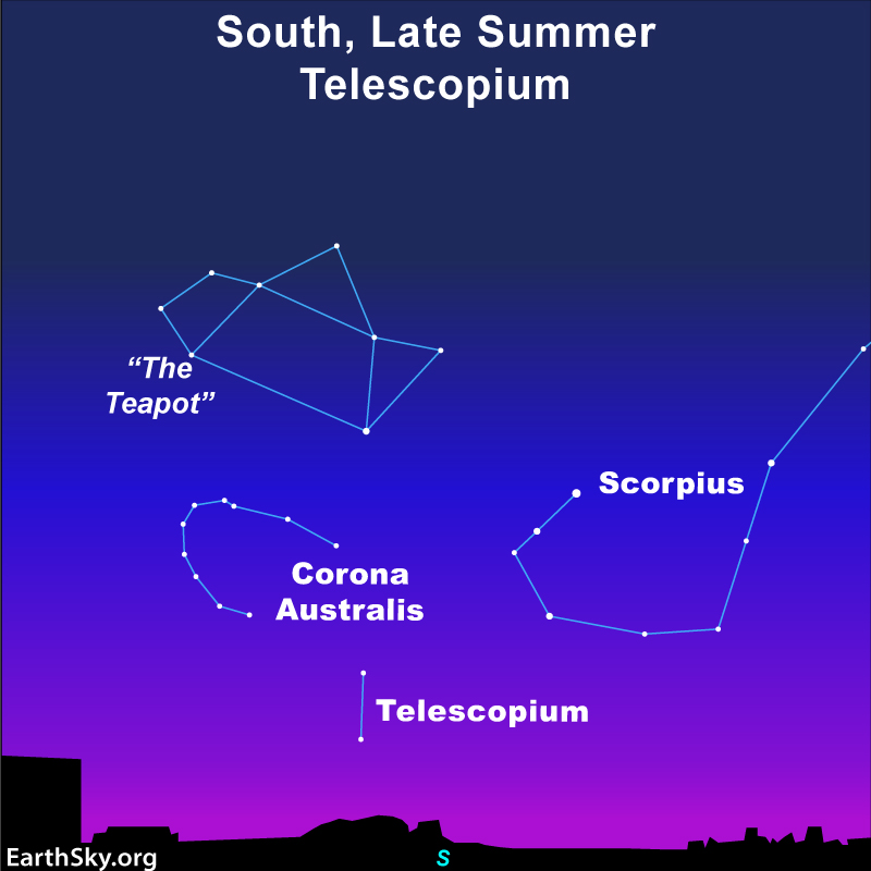
Star chart with the Teapot, Scorpius, Corona Australis and Telescopium near horizon.
To see the constellation Telescopium from the Northern Hemisphere, being farther south is better. Look right after sunset and enjoy it for a few hours before it disappears in the horizon. From the Southern Hemisphere, this constellation is hight in the sky all night. This chart shows the view from Houston, Texas, or around 30 degrees North latitude. Chart via EarthSky.

If you live toward the south in the Northern Hemisphere, you have a window in late summer and early fall (winter and spring in the Southern Hemisphere) when you can spot the diminutive constellation of Telescopium. Location alone is not enough, however. You’ll also want dark skies. Even the brightest star in Telescopium is rather dim: magnitude 3.51 Alpha Telescopii. Perhaps Telescopium is a fitting name, because to view anything in this constellation you’ll benefit from a telescope.

Nicolas Louis de Lacaille visited the Southern Hemisphere in the 18th century. He gave names to 14 new constellations. He named Telescopium in honor of the scientific instrument he used.

How to find Telescopium

Technically, most locations in the United States and others around 40 degrees North latitude will have the main stars in the constellation rise above their horizon. But, when you consider buildings along the southern horizon, light pollution and the dim stars of the constellation, your best bet is to be further south.

With this in mind, look right after sunset and find the Telescope by first finding brighter constellations above it. The Teapot of Sagittarius and the curving tail of Scorpius the Scorpion are the perfect places to start. If, however, the Scorpion is dragging its tail along the horizon from your point of view, you’re out of luck.

Also, if you look below the half of the Teapot that is closest to Scorpius, past the arcing curve of Corona Australis, you may spot two rather dim stars. One is on top of the other. These two stars are all that make up the shape of Telescopium the Telescope.

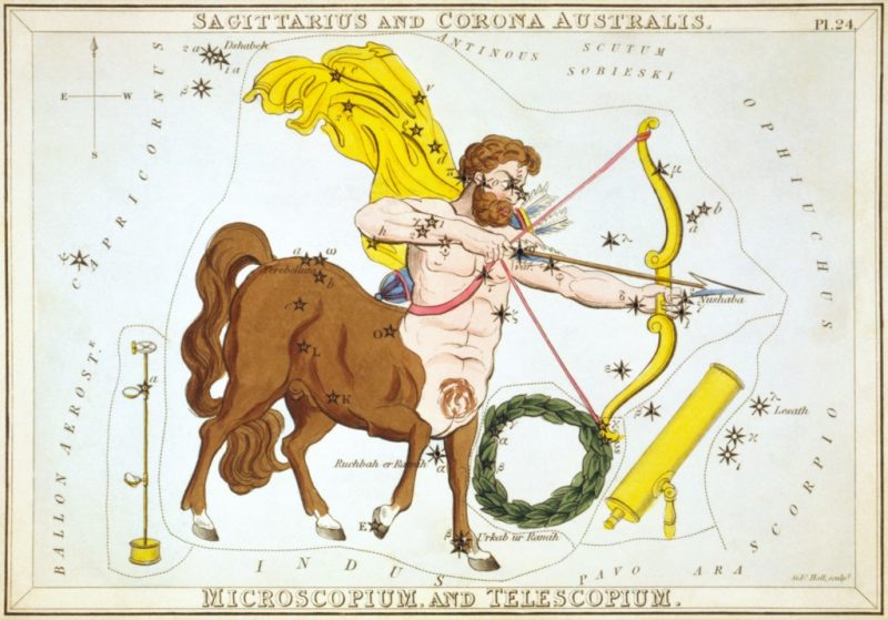
Drawing of a half-man, half-horse, wreath and Telescopium the telescope.
Telescopium lies close to Corona Australis and Sagittarius the Archer. Image via Wikimedia Commons.

Stars in the Telescope

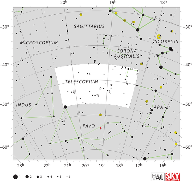
The brightest star in Telescopium is Alpha Telescopii at magnitude 3.51. It lies 278 light-years away.

Its second brightest star is just 3 degrees to the south: 4.09 Zeta Telescopii. It lies 127 light-years away.

Then, less than a degree to the southeast of Alpha is the double star Delta 1 and Delta 2 Telescopii. The brighter member, Delta 1, lies 795.5 light-years away and shines at magnitude 4.92. Delta 2, conversely, lies 1,116.9 light-years away and shines at magnitude 5.07. The pair lies less than 10 arcminutes apart.

White chart with black dots showing Telescopium with black hole labeled.
The stars of Telescopium. Image via IAU/ Sky & Telescope/ Wikipedia.

The black hole that wasn’t

In 2020, the European Southern Observatory announced the discovery of the closest black hole to Earth, 1,000 light-years away, in a corner of Telescopium. However, a study released in 2022 found it was simply a binary star system and did not contain a black hole.

Bottom line: Telescopium the Telescope is a constellation that appears best in southern skies.

The post Telescopium the Telescope is below the Teapot first appeared on EarthSky.


from EarthSky https://ift.tt/VuvaxwP

Kaboom! SpaceX rocket booster explodes on landing


Watch the SpaceX rocket booster first stage explode on the deck of its droneship, when a landing leg gives out.

SpaceX rocket booster has fiery landing

A SpaceX booster suffered a rare failure while attempting to land on its droneship in the Atlantic Ocean off the coast of Florida on Wednesday morning, August 28, 2024. The Falcon 9 booster is meant to be reusable. And this booster – named B1062 – was on its 23rd mission when it toppled over upon landing. The first stage of Falcon 9 rocket boosters routinely return to Earth for droneship landings. But this time, booster B1062 had one of its three landing legs give out, causing the booster to fall on its side on the deck of the droneship in a fiery explosion. RIP, B1062!

The Falcon 9 booster successfully deployed 21 Starlink satellites before it exploded. SpaceX had been planning a second Starlink launch from California just hours later. But after the booster incident, the company decided to stand down on the second launch in order to assess the situation in Florida.

No word yet on how the droneship – named A Shortfall of Gravitas – fared after the incident.

Upcoming Polaris Dawn

SpaceX had another rocket booster mishap earlier this year with an in-flight failure on July 11, 2024. That Falcon 9 rocket failed to boost its payload of Starlink satellites into their proper orbits. The rocket’s upper stage had a leak of liquid oxygen, which resulted in the FAA’s grounding the SpaceX Falcon 9. After two weeks, the Falcon 9 returned to flight on July 27, delivering 23 Starlink satellites to orbit from Florida.

Falcon 9 will be the rocket to boost the Polaris Dawn mission into space, possibly later this week. This mission involves four civilians and the first all-civilian spacewalk. It was supposed to launch early Tuesday morning from Kennedy Space Center in Florida. Then it was supposed to launch Wednesday. But weather and other issues have pushed back the launch twice this week. The launch is currently set for no earlier than 3:38 a.m. EDT (7:38 UTC) on Friday, August 30, 2024.

Watch the early morning launch with EarthSky’s Dave Adalian and Deborah Byrd, in the video below. We’ll start around 3:30 a.m. EDT, maybe slightly earlier, on Friday.

Bottom line:A SpaceX rocket booster – the Falcon 9 B1062 – suffered a rare failure overnight. The first stage tipped over and exploded while attempting to land on a droneship. RIP, B1062!

The post Kaboom! SpaceX rocket booster explodes on landing first appeared on EarthSky.


from EarthSky https://ift.tt/Mx6W1Cm

Humpback whales manufacture and wield tools


This video from 2019 provides an overview of humpback whales and their ability to create bubble nets to trap prey. Via University of Hawaii at Manoa.

  • Humpback whales have long been known to create bubble nets for hunting.
  • The whales should be considered “tool wielders,” says a new study. That’s because the study shows whales manipulating the bubble nets in a variety of ways, to maximize their food intake in their Alaskan feeding grounds.
  • The scientists used suction-cup tags and drones to study these behaviors among whales.

Humpback whales as tool wielders

It’s long been known that humpback whales near the ocean surface sometimes feed by blowing bubbles to corral prey like krill and small fish. In the jargon of scientists, the whales are using bubble nets. What’s fascinating is that the bubble nets are, in essence, tools created by the whales. Now, a new study shows that the whales are able to manipulate their bubble net tools, to maximize the amount of prey they catch. This result has prompted these scientists to label the whales as tool wielders.

Lars Bejder, co-lead author of the study and director of the Marine Mammal Research Program at the UH Hawai’i Institute of Marine Biology, explained in a statement:

Many animals use tools to help them find food. But very few actually create or modify these tools themselves.

We discovered that solitary humpback whales in southeast Alaska craft complex bubble nets to catch krill, which are tiny shrimp-like creatures. These whales skillfully blow bubbles in patterns that form nets with internal rings, actively controlling details like the number of rings, the size and depth of the net, and the spacing between bubbles. This method lets them capture up to seven times more prey in a single feeding dive without using extra energy.

This impressive behavior places humpback whales among the rare group of animals that both make and use their own tools for hunting.

This study was published in Royal Society Open Science on August 21, 2024.

Humpback whales shape bubble nets for better hunting

There are several populations of humpback whales worldwide. But the whales in this study spend the summer and fall feeding off the coast of southeast Alaska. There, they feed intensively to build up fat reserves. That’s because they’ll need that stored fat to sustain them as they migrate to waters off Hawaii where they spend the winter months. And during that time, they do not feed.

To accomplish the huge task of feeding themselves, these humpback whales (Megaptera novaeangliae) exhale complex bubble structures from their blowholes. They do this while swimming in a circular path below their prey. The rising bubbles form vertical “nets” that disorient and direct prey, such as krill and small fish, into a tight area where they can be easily swallowed.

This feeding behavior has been seen in individual whales and also in cooperative hunting groups. In this study, scientists reported on the feeding strategy of individual humpback whales in waters off southeast Alaska.

Top view of a whale in the middle of big concentric rings of bubbles. Explanatory text.
This infographic illustrates the bubble net technique of a humpback whale. Image via Hawai’i Institute of Marine Biology/ Marine Mammal Research Program/ Alaska Whale Foundation.

How scientists studied the whales

Scientists used tags with motion sensors and video cameras to study the humpback whales. These tags were temporarily suction-cupped to five whales to track their movements. In addition, the researchers used drones to monitor the whales from above. Data from this equipment allowed them to reconstruct a three-dimensional view of the whale’s foraging techniques with bubble nets.

William Gough, also of the University of Hawai’i at Manoa, said:

We deployed non-invasive suction-cup tags on whales and flew drones over solitary bubble-netting humpback whales in southeast Alaska, collecting data on their underwater movements. Whales are a difficult group to study, requiring skill and precision to successfully tag and/or drone them.

This little-studied foraging behavior is wholly unique to humpback whales. It’s so incredible to see these animals in their natural habitat, performing behaviors that only a few people ever get to see. And it’s rewarding to be able to come back to the lab, dive into the data, and learn about what they’re doing underwater once they disappear from view.

And Bejder said their research will guide further study of M. novaeangliae:

This is a rich dataset that will allow us to learn even more about the physics and energetics of solitary bubble-netting. There is also data coming in from humpback whales performing other feeding behaviors, such as cooperative bubble-netting, surface feeding, and deep lunge feeding, allowing for further exploration of this population’s energetic landscape and fitness.

A man in a red boat, touching a whale's back with a tag on the end of a long pole.
Using a long pole, Will Gough attaches a suction cup tag to a humpback whale in southeast Alaska. It was one of five humpback whales tagged in this study. Image via Marine Mammal Research Program/ Alaska Whale Foundation.

Efficient hunting is key to whales’ survival

Understanding how cetaceans, such as humpback whales, hunt helps resource managers monitor and conserve habitat in the waters where they feed. That’s because these creatures face many threats, such as climate change, degraded habitats and overfishing, as well as chemical and noise pollution. Andy Szabo, of the Alaska Whale Foundation, commented in the statement:

What I find exciting is that humpbacks have come up with complex tools allowing them to exploit prey aggregations that otherwise would be unavailable to them. It is this behavioral flexibility and ingenuity that I hope will serve these whales well as our oceans continue to change.

Three people in a red inflatable boat. Nearby, a whale’s tail sticks out of the water.
Scientists in a boat waiting for the right conditions to approach a whale to tag it. Image via Marine Mammal Research Program/ Alaska Whale Foundation.

Bottom line: Humpback whales create and manipulate bubble nets as tools. Alone and in groups, the whales use the nets to encircle prey and maximize their catch.

Source: Solitary humpback whales manufacture bubble-nets as tools to increase prey intake

Via University of Hawai’i at Manoa

Read more: Whales are the biggest living animals: Lifeform of the week

The post Humpback whales manufacture and wield tools first appeared on EarthSky.


from EarthSky https://ift.tt/CSIFT5K

Measuring the speed of winds on Mars using sound

Winds on Mars: 3 men sitting inside a small enclosed space, with 2 small mechanical instruments between them.
Researchers Robert White (left), Ian Neeson (center) and Don Banfield (right) in the Mars Simulation Wind Tunnel at the University of Aarhus, Denmark, in 2019. They are preparing to test early prototypes of the Mars sonic anemometer (center of image). The 2 prototypes were created by Tufts University (left) and VN Instruments (right). New research led by Tufts University in Massachusetts will help scientists measure the speed of winds on Mars more accurately than ever before. Image via White/ Neeson/ Banfield/ American Institute of Physics/ EurekAlert!
  • Mars has winds, despite its extremely thin atmosphere. How fast can Martian winds blow?
  • Researchers can now measure wind speeds on Mars using a new method that involves the travel time of sound.
  • The new method is faster than previous ones, works better measuring low-speed winds and can measure various kinds of winds.

Mars’ thin, windy atmosphere

Mars’ atmosphere is extremely thin, but it does have winds. The thinness of the atmosphere, however, makes measuring wind speeds difficult. Landers and rovers have been able to determine wind speeds with pretty good accuracy. But those measurements can still be improved. On August 13, 2024, researchers from the U.S. and Canada said they have a new method of measuring wind speeds on Mars, by using the travel time of sound.

The researchers published their peer-reviewed findings in The Journal of the Acoustical Society of America on August 13, 2024.

A new way to measure winds on Mars

Until now, landers and rovers on Mars have used various methods to measure winds. These include gauging the cooling rate of heated materials when winds blow over them and using cameras to image “tell-tales” that blow in the wind, akin to those used in sailing. Those techniques work, but scientists want to be able to measure wind speeds even more accurately.

Now, a team of researchers in the U.S. and Canada, led by Robert White at Tufts University in Medford, Massachusetts, have come up with a new method. Basically, it is a sonic anemometric (anemometer) system. An anemometer measures wind speed and direction. The system features a pair of narrowband piezoelectric transducers, which converts electrical charges into energy.

Using travel time of sound to measure wind speeds

The new system can measure the travel time of sound pulses through Martian air. White explained:

By measuring sound travel time differences both forward and backward, we can accurately measure wind in three dimensions. The two major advantages of this method are that it’s fast and it works well at low speeds.

The team tested the ultrasonic transducers and sensors over a wide range of temperatures and a narrow range of pressures in carbon dioxide. Mars’ atmosphere is composed of about 95% carbon dioxide. The tests showed only nominal error rates.

Replicating Martian conditions as closely as possible was crucial for the testing. The paper stated:

The acoustic conditions on Mars are similar to those in Earth’s stratosphere at 30 to 42 kilometers (19 to 26 miles) of altitude. Hence, testing was also conducted in dry air over the same range of pressures and temperatures with relevance to a secondary application of the instrument as a stratospheric anemometer for high altitude balloon missions on Earth.

Bright gust of dust blowing across sandy, rocky terrain with dusty sky above.
View larger. | NASA’s Perseverance rover captured this gust of wind blowing dust on June 18, 2021. Despite the thin atmosphere, winds, dust devils and dust storms are a common occurrence. Image via NASA/ JPL-Caltech.

Multiple wind speeds and various kinds of winds on Mars

The new technique also takes into account variables such as transducer diffraction effects and wind direction. The researchers said they should be able to measure multiple wind speeds at once – up to 100 measurements per second – as slow as 1 centimeter per second. Previously, other methods could only measure one wind speed per second. They could also only ideally measure speeds above 1 cm/s.

As White explained, the improved method will allow planetary scientists to measure different kinds of winds on Mars as well. Such measurements would also be crucial for future human missions to the red planet. Mars is famous for its dust storms and dust devils, which could endanger habitats. White said:

By measuring quickly and accurately, we hope to be able to measure not only mean winds, but also turbulence and fluctuating winds. This is important for understanding atmospheric variables that could be problematic for small vehicles such as the Ingenuity helicopter that flew on Mars recently.

The system we’re developing will be 10 times faster and 10 times more accurate than anything previously used. We hope it will produce more valuable data as future missions to Mars are considered and provide useful information on the Martian climate, perhaps also with implications for better understanding the climate of our own planet.

Bottom line: Scientists have developed a new technique – using the travel time of sound – to measure the speeds of winds on Mars with greater accuracy than ever before.

Source: Modeling and characterization of gas coupled ultrasonic transducers at low pressures and temperatures and implications for sonic anemometry on Mars

Via American Institute of Physics (EurekAlert!)

Read more: Where does Mars’ methane come from? Not wind

Read more: Dust storms swirl at Mars’ north pole

The post Measuring the speed of winds on Mars using sound first appeared on EarthSky.


from EarthSky https://ift.tt/Pf0ipk2

Sagitta the Arrow lies inside the Summer Triangle

Star chrt showing Summer Triangle, Delphinus, Vulpecula and Sagitta.
In the east on June, July and August evenings, you’ll find the large pattern of the Summer Triangle, made of 3 bright stars. And from a dark sky, you can also spot Sagitta the Arrow inside the triangle. Chart via EarthSky.

Even though the constellation of Sagitta the Arrow has been around since the 2nd century, it contains dim stars and is the third smallest of the 88 constellations. Sagitta the Arrow is sometimes related to Sagittarius the Archer; however, the two do not lie next to each other in the sky. Sagittarius lies low on the southern horizon during northern summer, while Sagitta is farther north. It almost appears as if Sagittarius has shot his arrow at Aquila the Eagle and missed, and the arrow (Sagitta) now lies on the other side of the Eagle from Sagittarius.

Locating Sagitta

Sagitta may be small and dim, but its position inside the Summer Triangle makes it easy to find. Sagitta and Vulpecula are the two constellations that take up residence between the constellations Cygnus the Swan, Lyra the Harp and Aquila the Eagle. Each of those constellations has one bright star that marks a corner of the Triangle: Cygnus’s star is Deneb, Lyra’s star is Vega, and Aquila’s star is Altair.

Sagitta lies north of Altair, inside the pointy end of the Summer Triangle. It consists of a line for the arrow’s shaft, and then it branches off on one end. Does it look like an arrow to you?

Stars of Sagitta the Arrow

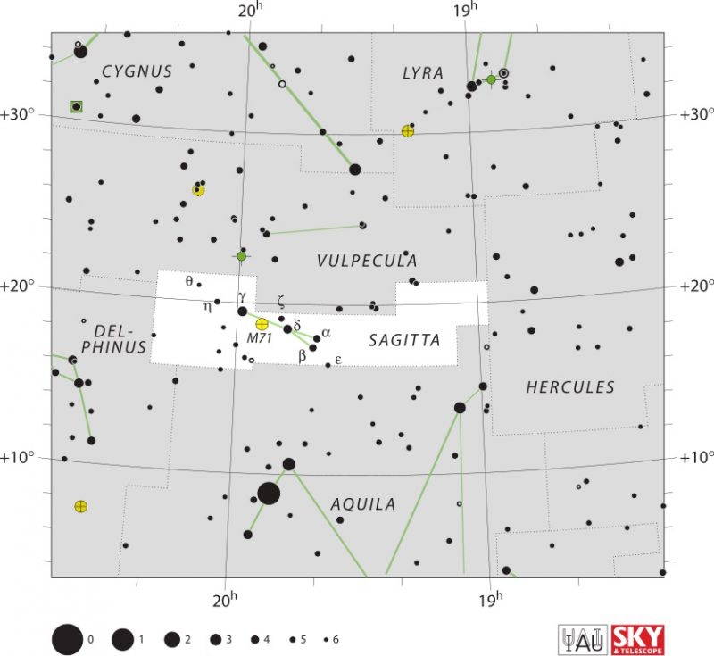
Because of Sagitta’s small size, it contains few observing targets. The brightest star is Gamma Sagittae. At magnitude 3.5, it lies 274 light-years away. About 3 degrees west is Delta Sagittae, a magnitude 3.8 star lying 448 light-years away. Then just a bit less than 2 degrees west of Delta are two stars both at magnitude 4.3. The one slightly north is Alpha Sagittae and the one slightly south is Beta Sagittae. Alpha lies 620 light-years from Earth, while Beta lies 470 light-years away from us.

White star chart with black dots denoting the small arrow.
The stars of Sagitta the Arrow. Image via IAU.

Sagitta’s Messier object

The one notable deep-sky target in Sagitta is also its only Messier object: the globular cluster M71. You can find M71 halfway between the stars Gamma and Delta. At magnitude 6.1, you’ll need binoculars or a telescope to spot it. Because of M71’s appearance, astronomers long thought that it was an open cluster with a rather dense center. Astronomers now believe it’s a young globular cluster that is smaller and looser than typical globular clusters. M71 lies about 13,000 light-years distant.

Bottom line: Sagitta the Arrow is a dim constellation that lies inside the Summer Triangle. It contains one Messier object, a small globular cluster.

The post Sagitta the Arrow lies inside the Summer Triangle first appeared on EarthSky.


from EarthSky https://ift.tt/kJpZQTL

Ancient Mars lake was larger than any on Earth

Lake on Mars: Orbital view. Large craters and false colors from red to yellow to deep blue in different areas.
View larger/full image. | This color-coded topographic map from ESA’s Mars Express orbiter shows part of what used to be a massive lake (in blue), called Lake Eridania by earthly scientists. It’s in the Caralis Chaos region on Mars. It appears to have been the largest Mars lake, bigger than any known earthly lake. Image via ESA/ DLR/ FU Berlin (CC BY-SA 3.0 IGO).
  • Mars had lakes billions of years ago. They eventually dried up and disappeared when Mars’ climate became too cold and its atmosphere too thin to support liquid water.
  • Which lake was the largest? The Mars Express spacecraft has taken new images of a vast ancient lakebed, called Lake Eridania by earthly scientists. It was the largest known lake on Mars, larger than any known earthly lake.
  • The lakebed is in a region of ancient volcanic terrain with mounds, cracks and ridges.

Mars may only be half the size of Earth, but – in part due to Mars’ low gravity – the geologic features are big. The red world has canyons and volcanoes far larger than any on our planet. Now there’s evidence that one of Mars’ ancient lakes was also bigger than any known lake on Earth. The European Space Agency (ESA) said on August 7, 2024, that its Mars Express orbiter obtained new views of the ancient lakebed in a region called Caralis Chaos. This lakebed – which presumably contained water billion of years ago – once covered more than a million square kilometers (386,000 square miles).

That’s about three times larger than the Caspian Sea, the largest inland body of water on Earth. Earthly scientists call this ancient Mars lake by the name Lake Eridania.

A vast ancient lake on Mars

The ancient lakebed, now dry for billions of years, is filled with raised mounds. Scientists say they were formed by Martian winds blowing dust. Later, it appears, water covered the dust. And still later – as water disappeared from Mars’ surface – the dust dried out again and broke apart into the mounds we see today.

There are still a few old lake basins visible in Caralis Chaos today. But Lake Eridania is the biggest one. It’s the biggest lake on Mars, larger than any known earthly lake. The water in this huge lake ultimately disappeared, along with all the rest of the water on Mars. How did that happen? Again, due to Mars’ low gravity, the planet couldn’t hold onto much of an atmosphere. So, today, Mars’ atmosphere is thin. Plus Mars is farther than Earth from the sun. So, without an atmosphere to help warm it, Mars became cold. Scientists say that, over time, the one massive lake, Lake Eridania, became a series of smaller lakes as it dried out.

When it was still one lake, it contained enough water to fill the Caspian Sea almost three times over. The Caspian Sea is Earth’s biggest inland body of water. It’s about 750 miles (1,200 km) long by 200 miles (320 km) wide.

Reddish terrain seen from orbit with craters, ridges and 2 long cracks.
View larger. | The Caralis Chaos region, as seen by Mars Express, where the lake once existed. Image via ESA/ DLR/ FU Berlin (CC BY-SA 3.0 IGO).
Reddish terrain with many small, bumpy hills, some craters, and some long, large cracks.
View larger. | Perspective view from Mars Express of Caralis Chaos. Image via ESA/ DLR/ FU Berlin (CC BY-SA 3.0 IGO).

Caralis Chaos

Caralis Chaos is what scientists call chaotic terrain. That is areas where mountains, plateaus, cracks and rifts are arranged in jumbled patterns.

So there’s evidence for past liquid water in this region. and there is also evidence for past volcanism in Caralis Chaos: two huge faults, or cracks, that run through the region. These are the Sirenum Fossae faults. They formed when the Tharsis plateau region formed. That upwelling caused stress in Mars’ crust, creating the faults. The planet’s largest volcanoes, including Olympus Mons, are found in the Tharsis region. And in fact, Olympus Mons itself may have once been an island!

There are also many “wrinkle” ridges in Caralis Chaos. They are also volcanic in origin and a common feature on volcanic plains. They form when new sheets of lava become compressed. Since the sheets are still soft, they easily buckle and become deformed. Wrinkle ridges are also common on the moon.

As on much of Mars, impact craters are also common here. Notably, a large central crater in this region has valleys carved out of its southern rim. Scientists say that this may be evidence for some water still existing even after the lake itself dried up. Other craters also feature small gullies, while others have been heavily eroded over time by Martian winds.

Orbital view of cratered reddish terrain. Featured sections are outlined and have text labels.
View larger. | Wider context view ofCaralis Chaos and surrounding region. The ancient lake would have also filled the flatter regions labelled Ariadnes Colles and Atlantis Chaos, as well as Caralis Chaos. Image via NASA/ ESA/ MGS/ MOLA Science Team.

Did Mars’ water go underground?

Speaking of how Mars’ water disappeared, it now seems that much or even most of it may simply have gone underground. You can read about the new evidence for a vast ocean’s worth of liquid water still existing in Mars’ crust today. That may include Lake Eridania and other lakes, as well as a possible ocean that once covered much of the northern hemisphere on Mars.

Bottom line: Lake Eridania was once the largest known lake on Mars. It was bigger than any lakes on Earth and contained three times as much water as the Caspian Sea.

Via ESA

Read more: Oceans of water on Mars deep underground?

Read more: Mars mission to send Blue and Gold satellites to red planet

The post Ancient Mars lake was larger than any on Earth first appeared on EarthSky.


from EarthSky https://ift.tt/EKwnOJR