
Record quiet Atlantic hurricane season so far
As of the morning of September 11, 2026, the Atlantic hurricane season set a new record for the quietest in the modern era. As the National Hurricane Center said on social media:
We officially passed the satellite-era (1966-present) record for the latest formation of the first hurricane during an Atlantic hurricane season, held by Hurricanes Gustav (2002) and Humberto (2013).
It’s important to remember that about half of a normal season’s activity happens after today. In fact, there has never been a season during the satellite era without the formation of at least 2 hurricanes. Late-starting years can still produce hurricane impacts—so stay prepared! Continue to visit Hurricanes.gov for the latest forecast.
Hurricanes Gustav (2002) and Humberto (2013) both formed on September 11 of their respective years.
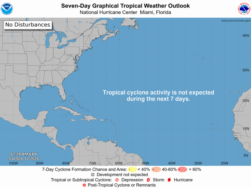
The forecast for the next seven days will continue the quiet streak we’ve seen so far. While we haven’t had any hurricanes in the Atlantic yet, we have had five named tropical storms: Arthur, Bertha, Cristobal, Dolly and Edouard.
Why the extra-quiet season? El Niño appears to be the driving force.
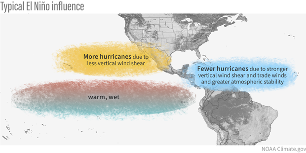
Why does El Niño mean fewer hurricanes?
El Niño conditions happen when warmer-than-average water pools in the eastern Pacific near equatorial South America. Normally, cold, nutrient-rich water rises from the deep ocean in this area. But El Niño blocks the upwelling of this cold water. So it disrupts marine life and local fisheries. And its effects cascade into Earth’s atmosphere, creating conditions like rainfall and temperature shifts in some parts of the world … and affecting wind shear.
It’s El Niño’s wind shear effects that have a major impact on hurricanes. Wind shear is the change in speed and direction of the wind. Specifically for hurricanes, what matters is the condition of wind shear at 5,000 to 35,000 feet (1,500 m to 10,700 m) above the ground.
In the Atlantic, El Niño can create strong wind shear, so strong it can rip apart storms or prevent them from forming in the first place. El Niño often brings a downstream trough of flowing winds over the Caribbean Sea and western tropical Atlantic. It’s this trough that brings the wind shear that can disrupt hurricane formation or growth. Plus, El Niño can bring sinking air to the region, which is a sign of an area of high pressure. And hurricanes are essentially huge, organized low-pressure systems.
While El Niño hinders the formation of strong hurricane activity in the Atlantic Ocean, it helps hurricane formation in the Pacific. El Niño creates a ridge over parts of the Pacific, which favors conditions such as weaker upper-level winds and less vertical wind shear.
In conditions such as these, hurricanes can grow without obstruction.
Read more: Hurricane triplets spin across the Pacific Ocean
An update to the Atlantic hurricane season forecast
After El Niño conditions were set in place this season, Colorado State University (CSU) revised its earlier hurricane forecast downward. The earlier forecast was already low, but now it is lower still.
On July 8, 2026, CSU predicts just nine named storms and just one major hurricane.
Back on April 9, the CSU forecast had called for 13 named storms, and two major hurricanes.
Both the National Oceanic and Atmospheric Administration (NOAA) and CSU release a forecast for the Atlantic hurricane season yearly. Earlier this year, both organizations called for a below-average year for tropical storms in the Atlantic basin.
CSU said:
Coastal residents are reminded that it only takes one hurricane making landfall to make it an active season for them.
As always, be aware and be prepared.
The original Atlantic hurricane season forecast for 2026
Originally, NOAA released its official forecast for the 2026 Atlantic hurricane season on May 21, 2026. And it predicted a below-average hurricane season, specifically, 8-14 total named storms (this includes both tropical storms and hurricanes), 3-6 hurricanes and 1-3 major hurricanes. NOAA did not make any changes to its 2026 forecast.
Hurricane season runs from June 1 through November 30.
What are the categories of hurricanes? Well, major hurricanes are those that reach Categories 3, 4 or 5.
- Category 3: 111–129 mph sustained winds (180-209 km/h)
- Category 4: 130–156 mph sustained winds (210-250 km/h)
- Category 5: 157 mph or higher sustained winds (251+ km/h)

Keep up-to-date with tropical conditions
To stay up-to-date on the tropics, visit NOAA’s National Hurricane Center page. You can toggle between Atlantic, Pacific and Central Pacific, as well as 2-day and 7-day forecasts.
Bottom line: The 2026 Atlantic hurricane season has set a record. It’s the longest we’ve ever gone in a hurricane season without seeing a hurricane.
Read more: Here’s the hurricane name list for 2026
The post Atlantic hurricane season sets a record: No hurricanes yet! first appeared on EarthSky.
from EarthSky https://ift.tt/MjZ8lA9
Record quiet Atlantic hurricane season so far
As of the morning of September 11, 2026, the Atlantic hurricane season set a new record for the quietest in the modern era. As the National Hurricane Center said on social media:
We officially passed the satellite-era (1966-present) record for the latest formation of the first hurricane during an Atlantic hurricane season, held by Hurricanes Gustav (2002) and Humberto (2013).
It’s important to remember that about half of a normal season’s activity happens after today. In fact, there has never been a season during the satellite era without the formation of at least 2 hurricanes. Late-starting years can still produce hurricane impacts—so stay prepared! Continue to visit Hurricanes.gov for the latest forecast.
Hurricanes Gustav (2002) and Humberto (2013) both formed on September 11 of their respective years.
The forecast for the next seven days will continue the quiet streak we’ve seen so far. While we haven’t had any hurricanes in the Atlantic yet, we have had five named tropical storms: Arthur, Bertha, Cristobal, Dolly and Edouard.
Why the extra-quiet season? El Niño appears to be the driving force.
Why does El Niño mean fewer hurricanes?
El Niño conditions happen when warmer-than-average water pools in the eastern Pacific near equatorial South America. Normally, cold, nutrient-rich water rises from the deep ocean in this area. But El Niño blocks the upwelling of this cold water. So it disrupts marine life and local fisheries. And its effects cascade into Earth’s atmosphere, creating conditions like rainfall and temperature shifts in some parts of the world … and affecting wind shear.
It’s El Niño’s wind shear effects that have a major impact on hurricanes. Wind shear is the change in speed and direction of the wind. Specifically for hurricanes, what matters is the condition of wind shear at 5,000 to 35,000 feet (1,500 m to 10,700 m) above the ground.
In the Atlantic, El Niño can create strong wind shear, so strong it can rip apart storms or prevent them from forming in the first place. El Niño often brings a downstream trough of flowing winds over the Caribbean Sea and western tropical Atlantic. It’s this trough that brings the wind shear that can disrupt hurricane formation or growth. Plus, El Niño can bring sinking air to the region, which is a sign of an area of high pressure. And hurricanes are essentially huge, organized low-pressure systems.
While El Niño hinders the formation of strong hurricane activity in the Atlantic Ocean, it helps hurricane formation in the Pacific. El Niño creates a ridge over parts of the Pacific, which favors conditions such as weaker upper-level winds and less vertical wind shear.
In conditions such as these, hurricanes can grow without obstruction.
Read more: Hurricane triplets spin across the Pacific Ocean
An update to the Atlantic hurricane season forecast
After El Niño conditions were set in place this season, Colorado State University (CSU) revised its earlier hurricane forecast downward. The earlier forecast was already low, but now it is lower still.
On July 8, 2026, CSU predicts just nine named storms and just one major hurricane.
Back on April 9, the CSU forecast had called for 13 named storms, and two major hurricanes.
Both the National Oceanic and Atmospheric Administration (NOAA) and CSU release a forecast for the Atlantic hurricane season yearly. Earlier this year, both organizations called for a below-average year for tropical storms in the Atlantic basin.
CSU said:
Coastal residents are reminded that it only takes one hurricane making landfall to make it an active season for them.
As always, be aware and be prepared.
The original Atlantic hurricane season forecast for 2026
Originally, NOAA released its official forecast for the 2026 Atlantic hurricane season on May 21, 2026. And it predicted a below-average hurricane season, specifically, 8-14 total named storms (this includes both tropical storms and hurricanes), 3-6 hurricanes and 1-3 major hurricanes. NOAA did not make any changes to its 2026 forecast.
Hurricane season runs from June 1 through November 30.
What are the categories of hurricanes? Well, major hurricanes are those that reach Categories 3, 4 or 5.
- Category 3: 111–129 mph sustained winds (180-209 km/h)
- Category 4: 130–156 mph sustained winds (210-250 km/h)
- Category 5: 157 mph or higher sustained winds (251+ km/h)
Keep up-to-date with tropical conditions
To stay up-to-date on the tropics, visit NOAA’s National Hurricane Center page. You can toggle between Atlantic, Pacific and Central Pacific, as well as 2-day and 7-day forecasts.
Bottom line: The 2026 Atlantic hurricane season has set a record. It’s the longest we’ve ever gone in a hurricane season without seeing a hurricane.
Read more: Here’s the hurricane name list for 2026
The post Atlantic hurricane season sets a record: No hurricanes yet! first appeared on EarthSky.
from EarthSky https://ift.tt/MjZ8lA9

Aucun commentaire:
Enregistrer un commentaire