
Will El Niño become supersized?
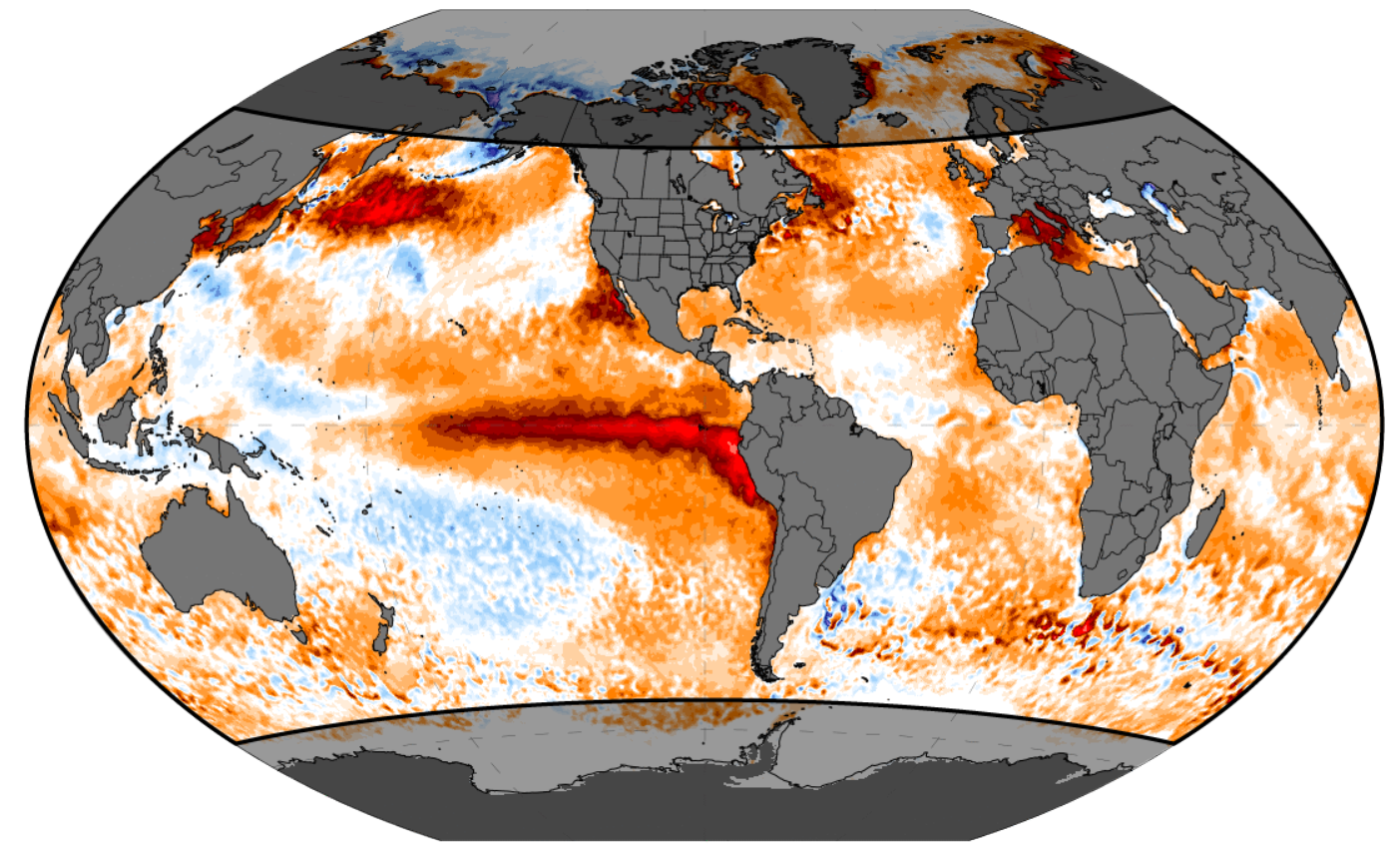
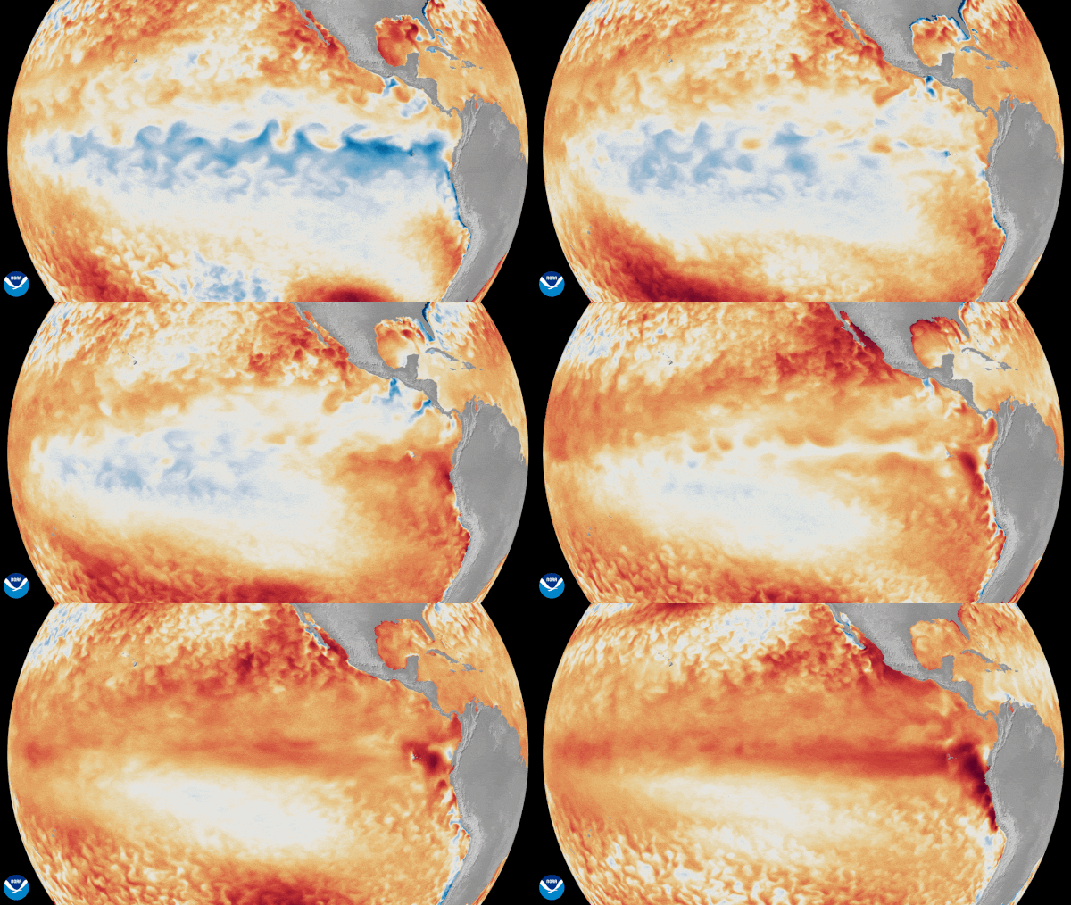
El Niño is officially here, NOAA’s National Weather Service said in June. The conditions were met after the sea surface temperatures in the equatorial Pacific Ocean rose 0.5°C above average for several months. And now NOAA says there’s a 90% or greater chance we see a very strong El Niño between September 2026 and January 2027.
Climate scientist Daniel Swain of the University of California said there is a:
high likelihood (~70%) that the 2026 event will become the strongest on record (since at least 1950) later this year, likely peaking in intensity between October and December.
The Columbia Climate School agrees. It said on August 19:
Despite some uncertainty in the projected peak intensity, the forecast consensus is clear: a strong El Niño is highly likely to develop and persist through late 2026.
Swain also discussed what the global effects of this supersized El Niño could be:
By increasing the total amount of heat and water vapor in the Earth’s atmosphere, and by shifting global storm tracks, this event will likely contribute to significant regional drought and flood events, as well as extreme heat. Additionally, the temporary effects from this very strong El Niño event will amplify the effect of long-term warming from climate change, greatly elevating the likelihood of record-breaking global temperatures and extreme weather events during 2026-2027.
A super El Niño
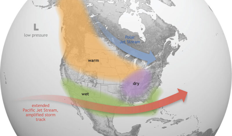
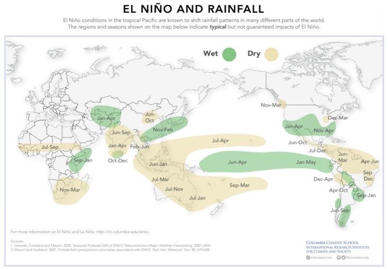
Some meteorologists have been calling the very strong conditions a super El Niño. El Niño is the warm phase of a weather pattern based on the sea surface temperatures in the eastern Pacific Ocean. This pattern drives weather, including temperatures and amounts of precipitation. El Niño conditions bring different weather to different places. You can see the overall trends in the charts below.
What to expect from El Niño
There are some overall patterns that weather follows when we are in El Niño conditions. But you’ll still want to stay weather aware. As Ken Graham, director of NOAA’s National Weather Service, said:
Every El Nino is not the same; each one is unique with its own imprint on our weather.
But here’s a look at some of the likely weather scenarios during El Niño.
An El Niño usually brings higher global temperatures. The excess heat in the Pacific Ocean eventually enters the atmosphere. This causes warmer global temperatures. However, the rise in temperatures often has a lag time of a few months.
As Northern Illinois University meteorology professor Victor Gensini told PBS:
A strong El Niño could plausibly push global temperatures to new record levels in late 2026 and into 2027.
In the summer, El Niño can dampen hurricane formation in the Atlantic. And so far, the hurricane in the Atlantic has indeed been relatively quiet. Colorado State University even revised its earlier, already-low hurricane forecast downward in July.
Winter this season
It’s in winter that we feel El Niño the strongest. Often the jet stream will drop south, steering storms into California and Arizona and bringing much-needed rain. If the jet stream swings southward, then the southern and eastern U.S. can expect wetter and cooler weather. Meanwhile, drier weather could prevail in the northern U.S. and Great Lakes region.
Read more: Lake Powell hits record low, continues to drop
Across the globe, El Niño brings drought conditions to places such as Australia, India and central Africa. And it can bring heavy rains to southern South America and eastern Africa.
World Meteorological Organization (WMO) Secretary-General Celeste Saulo said on June 2, 2026:
We need to prepare for a potentially strong El Niño event, which will exacerbate drought and heavy rainfall and increase the risk of heatwaves both on land and in the ocean. The most recent El Niño, in 2023-24, was one of the five strongest on record and it played a role in the record global temperatures we saw in 2024.
Just like any weather event, preparation is key. The WMO said that nearly everywhere can expect above average temperatures for June to August.
WMO urges people to prepare
On Tuesday, June 2, 2026, the WMO, based in Geneva, Switzerland, urged people to prepare for El Niño. The WMO, a specialized agency of the United Nations that focuses on weather, climate and water resources, said:
Fueled by unusually warm ocean waters in the tropical Pacific, El Niño conditions are developing and are set to influence global temperature and rainfall patterns, increasing the risk of extreme weather over the coming months.
UN Secretary-General António Guterres did not hold back in a statement:
El Niño conditions will pour fuel on the fire of a warming world. Impacts will hit even harder, travel even farther, and cross borders with devastating speed. The only effective response is climate action equal to the crisis: ending the addiction to fossil fuels, accelerating the shift to renewables, protecting the most vulnerable, and delivering early warning systems for all.
Read more: The Atlantic hurricane season forecast for 2026 is out!
What is a super El Niño?
So what is a super El Niño compared to an El Niño? Let’s start by looking closer at a typical El Niño. There are three types of conditions that can guide global weather: El Niño, La Niña and neutral. These three conditions make up ENSO, or the El Niño–Southern Oscillation. ENSO is a natural climate pattern in the tropical Pacific Ocean that shifts between warm and cool phases. El Niño is the warm phase and La Niña is the cool phase. And these phases influence weather around the world, including rainfall, droughts and storms.
So an average El Niño occurs when warm water pools up in the eastern Pacific Ocean around the equator. Once the temperatures reach 0.5 degrees Celsius (0.9 F) warmer than normal in the sea surface, an El Niño has formed. El Niño conditions can last for up to a year.
A super El Niño is a stronger event. Meteorologists often call it a super El Niño when the sea surface temperature anomalies peak at about 2.0° C (3.6 F) above normal. And currently, some models are calling for the coming El Niño to exceed 2.5° C (4.5 F) above the seasonal average by October.
Staying safe in extreme heat
From EarthSky’s weather author, meteorologist Rachel Duensing:
Staying safe in extreme heat can vary a bit depending on your situation. But the main idea is to avoid the heat as much as possible. If you are able to stay inside, ideally in air-conditioning (A/C), this is your best option. But if you cannot avoid the hot weather, there are things you can do. Take frequent breaks in the shade. Make sure you’re staying hydrated. Wear light-colored, loose-fitting clothing. And pay close attention to how you’re feeling as the day goes on.
If you, or someone you are with, is sweating heavily, feeling weak, tired, dizzy or nauseated, these could be signs of heat exhaustion. Immediately move yourself or the other person into A/C. Loosen their clothing, give them sips of cool water and put cold compresses on their body.
If someone is acting confused and slurring their speech, has red and hot skin or passes out, this is likely a heat stroke. They need medical attention immediately! Call 911. While you wait for help to arrive, move the person to A/C, add cool compresses to lower their body temperature, but do not give them anything to drink.
The heat can also be more dangerous to the very young, the very old, people with chronic medical conditions and pregnant women. In addition, the unhoused and lower income communities, who may not be able to afford to run their air-conditioning, are also at risk. Check on your friends, family and neighbors before, during and after extreme heat.
Bottom line: El Niño is here. But will it become supersized? NOAA says there’s a 90% or greater chance for El Niño to become “very strong” between September and January.
Via:
National Weather Service (NOAA)
World Meteorological Organization
The post Will El Niño become supersized? What experts are saying first appeared on EarthSky.
from EarthSky https://ift.tt/Ez9CNPb
Will El Niño become supersized?
El Niño is officially here, NOAA’s National Weather Service said in June. The conditions were met after the sea surface temperatures in the equatorial Pacific Ocean rose 0.5°C above average for several months. And now NOAA says there’s a 90% or greater chance we see a very strong El Niño between September 2026 and January 2027.
Climate scientist Daniel Swain of the University of California said there is a:
high likelihood (~70%) that the 2026 event will become the strongest on record (since at least 1950) later this year, likely peaking in intensity between October and December.
The Columbia Climate School agrees. It said on August 19:
Despite some uncertainty in the projected peak intensity, the forecast consensus is clear: a strong El Niño is highly likely to develop and persist through late 2026.
Swain also discussed what the global effects of this supersized El Niño could be:
By increasing the total amount of heat and water vapor in the Earth’s atmosphere, and by shifting global storm tracks, this event will likely contribute to significant regional drought and flood events, as well as extreme heat. Additionally, the temporary effects from this very strong El Niño event will amplify the effect of long-term warming from climate change, greatly elevating the likelihood of record-breaking global temperatures and extreme weather events during 2026-2027.
A super El Niño
Some meteorologists have been calling the very strong conditions a super El Niño. El Niño is the warm phase of a weather pattern based on the sea surface temperatures in the eastern Pacific Ocean. This pattern drives weather, including temperatures and amounts of precipitation. El Niño conditions bring different weather to different places. You can see the overall trends in the charts below.
What to expect from El Niño
There are some overall patterns that weather follows when we are in El Niño conditions. But you’ll still want to stay weather aware. As Ken Graham, director of NOAA’s National Weather Service, said:
Every El Nino is not the same; each one is unique with its own imprint on our weather.
But here’s a look at some of the likely weather scenarios during El Niño.
An El Niño usually brings higher global temperatures. The excess heat in the Pacific Ocean eventually enters the atmosphere. This causes warmer global temperatures. However, the rise in temperatures often has a lag time of a few months.
As Northern Illinois University meteorology professor Victor Gensini told PBS:
A strong El Niño could plausibly push global temperatures to new record levels in late 2026 and into 2027.
In the summer, El Niño can dampen hurricane formation in the Atlantic. And so far, the hurricane in the Atlantic has indeed been relatively quiet. Colorado State University even revised its earlier, already-low hurricane forecast downward in July.
Winter this season
It’s in winter that we feel El Niño the strongest. Often the jet stream will drop south, steering storms into California and Arizona and bringing much-needed rain. If the jet stream swings southward, then the southern and eastern U.S. can expect wetter and cooler weather. Meanwhile, drier weather could prevail in the northern U.S. and Great Lakes region.
Read more: Lake Powell hits record low, continues to drop
Across the globe, El Niño brings drought conditions to places such as Australia, India and central Africa. And it can bring heavy rains to southern South America and eastern Africa.
World Meteorological Organization (WMO) Secretary-General Celeste Saulo said on June 2, 2026:
We need to prepare for a potentially strong El Niño event, which will exacerbate drought and heavy rainfall and increase the risk of heatwaves both on land and in the ocean. The most recent El Niño, in 2023-24, was one of the five strongest on record and it played a role in the record global temperatures we saw in 2024.
Just like any weather event, preparation is key. The WMO said that nearly everywhere can expect above average temperatures for June to August.
WMO urges people to prepare
On Tuesday, June 2, 2026, the WMO, based in Geneva, Switzerland, urged people to prepare for El Niño. The WMO, a specialized agency of the United Nations that focuses on weather, climate and water resources, said:
Fueled by unusually warm ocean waters in the tropical Pacific, El Niño conditions are developing and are set to influence global temperature and rainfall patterns, increasing the risk of extreme weather over the coming months.
UN Secretary-General António Guterres did not hold back in a statement:
El Niño conditions will pour fuel on the fire of a warming world. Impacts will hit even harder, travel even farther, and cross borders with devastating speed. The only effective response is climate action equal to the crisis: ending the addiction to fossil fuels, accelerating the shift to renewables, protecting the most vulnerable, and delivering early warning systems for all.
Read more: The Atlantic hurricane season forecast for 2026 is out!
What is a super El Niño?
So what is a super El Niño compared to an El Niño? Let’s start by looking closer at a typical El Niño. There are three types of conditions that can guide global weather: El Niño, La Niña and neutral. These three conditions make up ENSO, or the El Niño–Southern Oscillation. ENSO is a natural climate pattern in the tropical Pacific Ocean that shifts between warm and cool phases. El Niño is the warm phase and La Niña is the cool phase. And these phases influence weather around the world, including rainfall, droughts and storms.
So an average El Niño occurs when warm water pools up in the eastern Pacific Ocean around the equator. Once the temperatures reach 0.5 degrees Celsius (0.9 F) warmer than normal in the sea surface, an El Niño has formed. El Niño conditions can last for up to a year.
A super El Niño is a stronger event. Meteorologists often call it a super El Niño when the sea surface temperature anomalies peak at about 2.0° C (3.6 F) above normal. And currently, some models are calling for the coming El Niño to exceed 2.5° C (4.5 F) above the seasonal average by October.
Staying safe in extreme heat
From EarthSky’s weather author, meteorologist Rachel Duensing:
Staying safe in extreme heat can vary a bit depending on your situation. But the main idea is to avoid the heat as much as possible. If you are able to stay inside, ideally in air-conditioning (A/C), this is your best option. But if you cannot avoid the hot weather, there are things you can do. Take frequent breaks in the shade. Make sure you’re staying hydrated. Wear light-colored, loose-fitting clothing. And pay close attention to how you’re feeling as the day goes on.
If you, or someone you are with, is sweating heavily, feeling weak, tired, dizzy or nauseated, these could be signs of heat exhaustion. Immediately move yourself or the other person into A/C. Loosen their clothing, give them sips of cool water and put cold compresses on their body.
If someone is acting confused and slurring their speech, has red and hot skin or passes out, this is likely a heat stroke. They need medical attention immediately! Call 911. While you wait for help to arrive, move the person to A/C, add cool compresses to lower their body temperature, but do not give them anything to drink.
The heat can also be more dangerous to the very young, the very old, people with chronic medical conditions and pregnant women. In addition, the unhoused and lower income communities, who may not be able to afford to run their air-conditioning, are also at risk. Check on your friends, family and neighbors before, during and after extreme heat.
Bottom line: El Niño is here. But will it become supersized? NOAA says there’s a 90% or greater chance for El Niño to become “very strong” between September and January.
Via:
National Weather Service (NOAA)
World Meteorological Organization
The post Will El Niño become supersized? What experts are saying first appeared on EarthSky.
from EarthSky https://ift.tt/Ez9CNPb

Aucun commentaire:
Enregistrer un commentaire