Have you seen clouds that are pouring rain … but the rain never reaches the ground? Meteorologists call this rain by the name virga. You see virga in places where the air is dry, and often warm. The rain evaporates as it falls, before hitting Earth. So you might see virga in a desert or at high altitudes, for example, in the western U.S. and Canadian prairies, the Middle East, Australia and North Africa. Virga isn’t rare. But it’s delicate and very beautiful. Maybe you’ve seen it lots of times, but never knew it had a name?
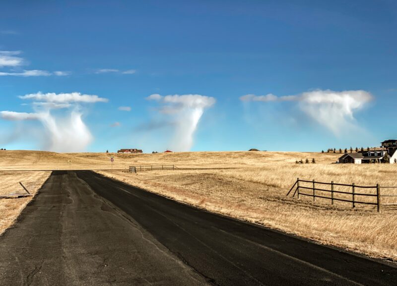
View at EarthSky Community Photos. | Ross Stone caught this virga – rain that doesn’t reach the ground – at Big Pine, California, on September 21, 2024. Good catch, Ross! Thank you.
Virga on radar
Sometimes, when you’re looking at your weather app, you might see what looks like rain or snow on the radar, but nothing is falling outside. Instead, look up at the clouds and see if you can spot virga. The radar is picking up precipitation in the air which is just not reaching the ground. As weather.gov says:
The radar isn’t lying, rather, the rain or snow is not hitting the ground. If you have a dry air mass in place in the low levels, sometimes rain cannot completely penetrate that dry layer before it evaporates.
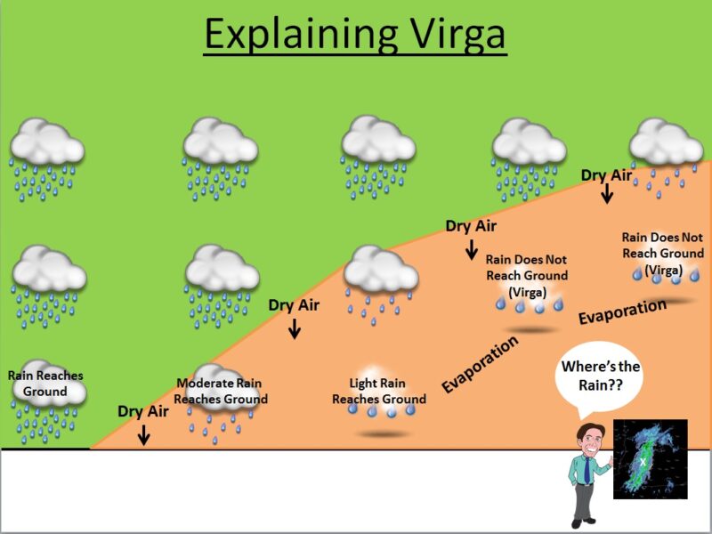
This graphic gives you a better idea of how virga forms. The rainclouds higher up in the atmosphere are dropping rain, but as that moisture hits drier air below, it evaporates. So you might see radar indicating rain or snow, but nothing is reaching the ground. Image via weather.gov (public domain).
Do you want to learn to identify virga when you see it? Check out the photos on this page from our global EarthSky community. Once you acquaint yourself with the variations of virga, you’ll be able to spot it in your own sky. If you capture a photo of virga, submit it to us!
Can you identify virga?
Photos of virga from EarthSky’s community
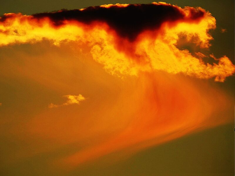
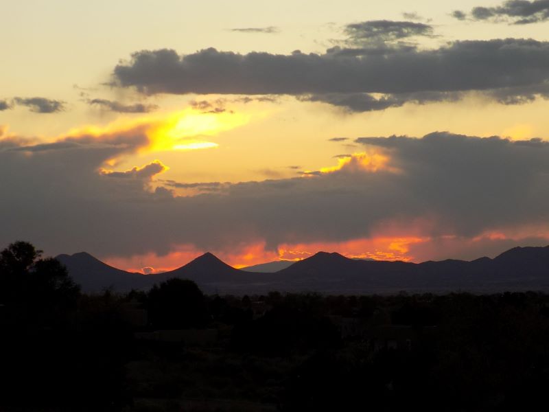
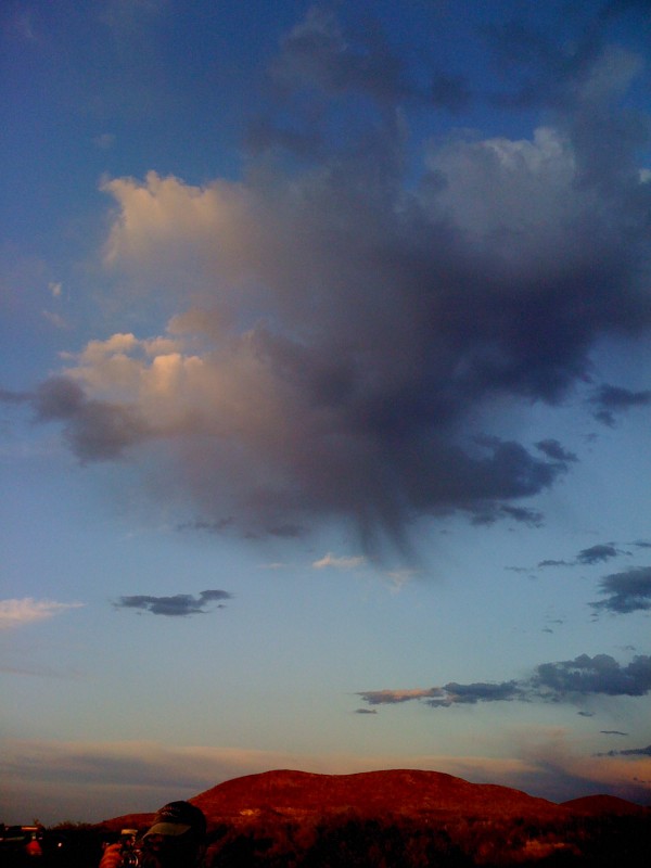
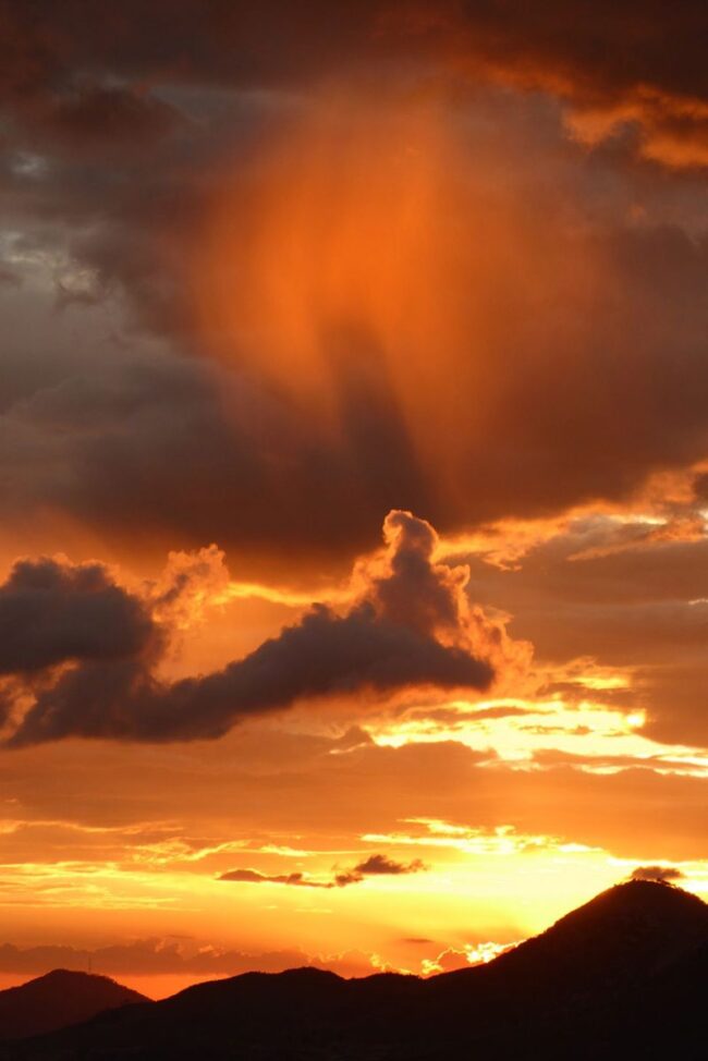
View at EarthSky Community Photos. | Susan Jensen captured this image on May 6, 2024, in Washington. She wrote: “Late afternoon thunder with a few brief lightning flashes caught my attention! These were such beautiful virga clouds.” Thank you, Susan.View at EarthSky Community Photos. | Helio C. Vital from Saquarema, Rio de Janeiro, Brazil, took this photo on December 17, 2023, and wrote: “The photo shows precipitation that is seen pending from a cloud and evaporating before reaching the ground (virga). The virga was backlit by the setting sun, that caused its strong reddish color.” Thank you, Helio!View at EarthSky Community Photos. | Jennifer Browne captured this scene of virga and New Mexico’s Sangre de Cristo Mountains on October 23, 2023. Jennifer wrote: “Looking west from my home. The magic of Santa Fe sunsets.” Thank you, Jennifer! Look closely, and you’ll see the wispy undersides of the clouds. That’s virga.
Virga photos
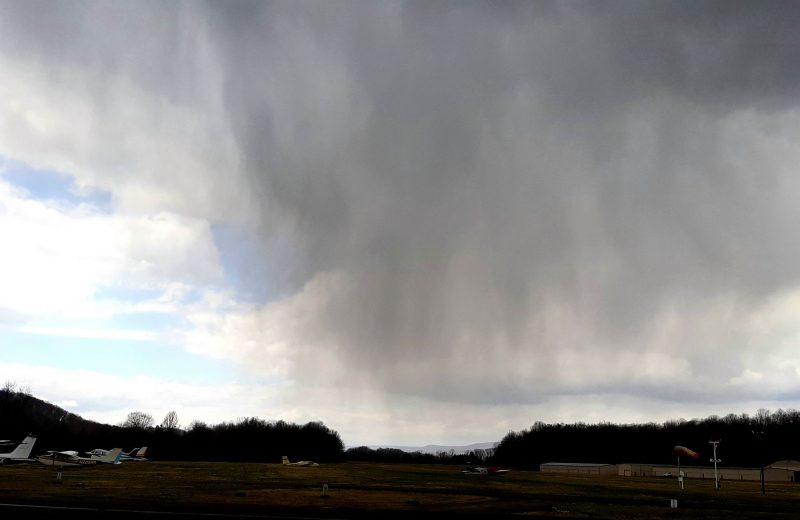
View at EarthSky Community Photos. | Sandi Hryhor in Blairstown, New Jersey, caught this image of virga on March 26, 2022. Sandi wrote: “Taken at the Blairstown airport. It was completely overcast when we left our house 10 miles away, then some sun, then it hailed, and this sky greeted us when we arrived.” Thank you for sharing!View at EarthSky Community Photos. | Jan Curtis took this photo on December 17, 2021, and wrote: “The lower levels of the atmosphere are very cold and moist. Lots of virga (ice crystals) are falling out of these thin cloud masses. Had this occurred in summer, severe weather is most likely later in the day. On this day, scattered convective snow shower occurred shortly after this mid-morning capture. An alternative cloud classification could be ‘altocumulus floccus clouds with virga’ but I believe these clouds were well below 6,000 feet [1,800 meters] above ground level.” Thank you, Jan!
More photos
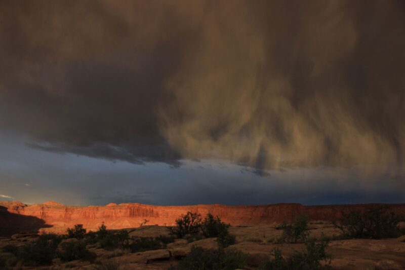
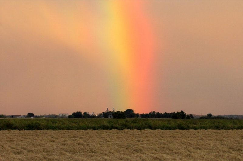
View at EarthSky Community Photos. | Wells Shoemaker from Burr Point, Utah, took this photo on April 22, 2019, and wrote: “Late sun slashed through a crease in the clouds to illuminate the Wingate and Navajo cliffs above the Dirty Devil River … through a lace of virga.” Thank you, Wells!Virga over West Texas. Image via EarthSky founder, Deborah Byrd.Peter Lowenstein captured this scene from Mutare, Zimbabwe, on March 5, 2019. He wrote: “Some lingering clouds and a strange curtain of virga left over after a late afternoon shower produced a spectacular display just after the sun had set below the horizon.” Thank you, Peter!View at EarthSky Community Photos. | Here’s a tricky one: a virga rainbow. Hazel Holby in Willows, California, captured this image on September 29, 2021. She wrote: “Can you tell me how this rainbow managed to form? Thank you and love your site!” Thank you, Hazel! Les Cowley of the website Atmospheric Optics said: “This is a broad bow and also of variable width. These suggest that it was made by virga or other small water droplets. The smaller the water drops, the broader the bow. When the drops get down to mist size, then we have a fogbow.” Thank you, Les!
Bottom line: Learn what virga is and how it forms, and see great photos to help you learn how to identify it yourself!
Have you seen clouds that are pouring rain … but the rain never reaches the ground? Meteorologists call this rain by the name virga. You see virga in places where the air is dry, and often warm. The rain evaporates as it falls, before hitting Earth. So you might see virga in a desert or at high altitudes, for example, in the western U.S. and Canadian prairies, the Middle East, Australia and North Africa. Virga isn’t rare. But it’s delicate and very beautiful. Maybe you’ve seen it lots of times, but never knew it had a name?
View at EarthSky Community Photos. | Ross Stone caught this virga – rain that doesn’t reach the ground – at Big Pine, California, on September 21, 2024. Good catch, Ross! Thank you.
Virga on radar
Sometimes, when you’re looking at your weather app, you might see what looks like rain or snow on the radar, but nothing is falling outside. Instead, look up at the clouds and see if you can spot virga. The radar is picking up precipitation in the air which is just not reaching the ground. As weather.gov says:
The radar isn’t lying, rather, the rain or snow is not hitting the ground. If you have a dry air mass in place in the low levels, sometimes rain cannot completely penetrate that dry layer before it evaporates.
This graphic gives you a better idea of how virga forms. The rainclouds higher up in the atmosphere are dropping rain, but as that moisture hits drier air below, it evaporates. So you might see radar indicating rain or snow, but nothing is reaching the ground. Image via weather.gov (public domain).
Do you want to learn to identify virga when you see it? Check out the photos on this page from our global EarthSky community. Once you acquaint yourself with the variations of virga, you’ll be able to spot it in your own sky. If you capture a photo of virga, submit it to us!
Can you identify virga?
Photos of virga from EarthSky’s community
View at EarthSky Community Photos. | Susan Jensen captured this image on May 6, 2024, in Washington. She wrote: “Late afternoon thunder with a few brief lightning flashes caught my attention! These were such beautiful virga clouds.” Thank you, Susan.View at EarthSky Community Photos. | Helio C. Vital from Saquarema, Rio de Janeiro, Brazil, took this photo on December 17, 2023, and wrote: “The photo shows precipitation that is seen pending from a cloud and evaporating before reaching the ground (virga). The virga was backlit by the setting sun, that caused its strong reddish color.” Thank you, Helio!View at EarthSky Community Photos. | Jennifer Browne captured this scene of virga and New Mexico’s Sangre de Cristo Mountains on October 23, 2023. Jennifer wrote: “Looking west from my home. The magic of Santa Fe sunsets.” Thank you, Jennifer! Look closely, and you’ll see the wispy undersides of the clouds. That’s virga.
Virga photos
View at EarthSky Community Photos. | Sandi Hryhor in Blairstown, New Jersey, caught this image of virga on March 26, 2022. Sandi wrote: “Taken at the Blairstown airport. It was completely overcast when we left our house 10 miles away, then some sun, then it hailed, and this sky greeted us when we arrived.” Thank you for sharing!View at EarthSky Community Photos. | Jan Curtis took this photo on December 17, 2021, and wrote: “The lower levels of the atmosphere are very cold and moist. Lots of virga (ice crystals) are falling out of these thin cloud masses. Had this occurred in summer, severe weather is most likely later in the day. On this day, scattered convective snow shower occurred shortly after this mid-morning capture. An alternative cloud classification could be ‘altocumulus floccus clouds with virga’ but I believe these clouds were well below 6,000 feet [1,800 meters] above ground level.” Thank you, Jan!
More photos
View at EarthSky Community Photos. | Wells Shoemaker from Burr Point, Utah, took this photo on April 22, 2019, and wrote: “Late sun slashed through a crease in the clouds to illuminate the Wingate and Navajo cliffs above the Dirty Devil River … through a lace of virga.” Thank you, Wells!Virga over West Texas. Image via EarthSky founder, Deborah Byrd.Peter Lowenstein captured this scene from Mutare, Zimbabwe, on March 5, 2019. He wrote: “Some lingering clouds and a strange curtain of virga left over after a late afternoon shower produced a spectacular display just after the sun had set below the horizon.” Thank you, Peter!View at EarthSky Community Photos. | Here’s a tricky one: a virga rainbow. Hazel Holby in Willows, California, captured this image on September 29, 2021. She wrote: “Can you tell me how this rainbow managed to form? Thank you and love your site!” Thank you, Hazel! Les Cowley of the website Atmospheric Optics said: “This is a broad bow and also of variable width. These suggest that it was made by virga or other small water droplets. The smaller the water drops, the broader the bow. When the drops get down to mist size, then we have a fogbow.” Thank you, Les!
Bottom line: Learn what virga is and how it forms, and see great photos to help you learn how to identify it yourself!


Aucun commentaire:
Enregistrer un commentaire