
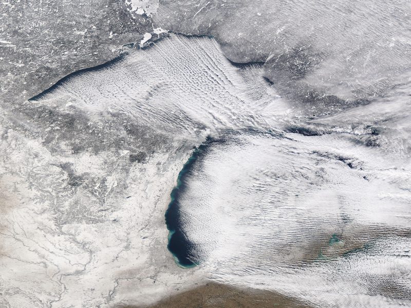
On February 3, 2026, NOAA shared the above image of clouds rolling off the southeastern United States in neat columns. Meteorologists call this phenomenon cloud streets. NOAA said:
The recent Arctic blast that prompted freeze warnings as far south as southern Florida also created a captivating phenomenon over the waters of the Gulf and Atlantic on Sunday, February 1, 2026. NOAA’s GOES East satellite captured long, parallel bands of clouds called horizontal convective rolls.
Better known as ‘cloud streets,’ these formations can develop when cold, dry air flows over relatively warmer water. As the air absorbs heat and moisture from below, rows of long, parallel lines of cumulus clouds form, usually aligned with the wind direction. In the satellite imagery above, a gap of clear skies is visible between the coastline and where the cloud streets begin. That’s due to the time and distance it takes the cold air to pick up the heat and moisture from the water to form clouds.
The frigid air that plunged southward on Sunday was some of the coldest that Florida has seen in years. Temperatures dropped to 23 degrees Fahrenheit in Winter Haven, 29 degrees in Tampa, 30 degrees in West Palm Beach and 35 degrees in Miami.
EarthSky’s 2026 lunar calendar is available now. Get yours today! Makes a great gift.
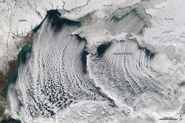
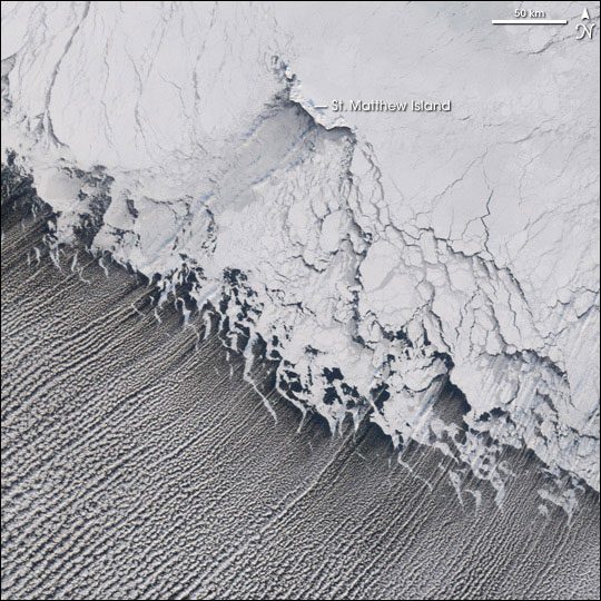
What are cloud streets?
Cloud streets are long rows of cumulus clouds that are oriented parallel to the direction of the wind. Their technical name, more specifically, is horizontal convective rolls. As a matter of fact, you’ve probably seen them in satellite photos. Typically, they most often form straight rows, but when the wind driving the clouds hits an obstacle, the clouds might curl into patterns and become von Kármán vortex streets.
How do cloud streets form?
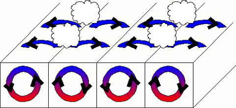
Convection rolls of rising warm air and sinking cool air form cloud streets. First, rising warm air cools gradually as it ascends into the atmosphere. Then, when moisture in the warm air mass cools and condenses, it forms clouds. Meanwhile, sinking cool air on either side of the cloud formation zone creates a cloud-free area. Later, when several of these alternating rising and sinking air masses align with the wind, cloud streets develop.
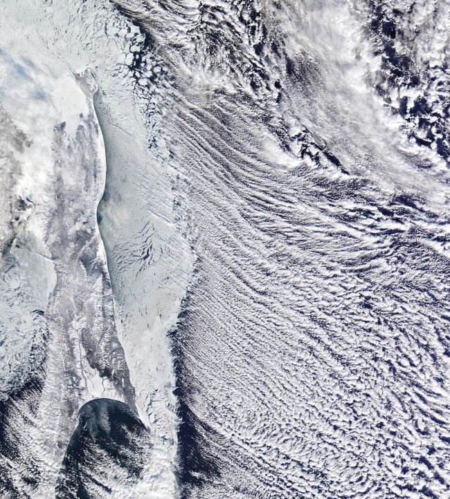
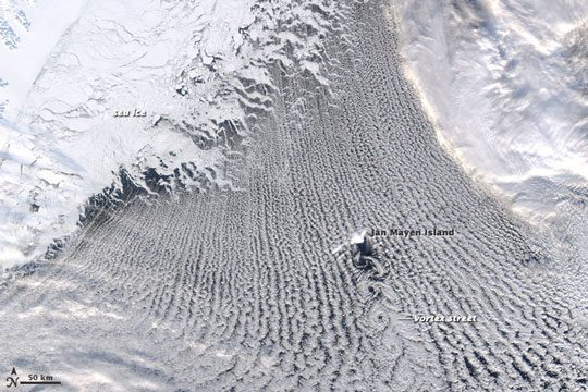
Typically, cloud streets form fairly straight lines over large, flat areas such as the ocean. However, when geological features like islands disrupt the flow of the wind, this disruption can create spiral patterns in the cloud streets. This is similar to the way in which large boulders create downstream eddies in rivers. Notably, the spiral patterns in clouds, called von Kármán vortex streets, were named after Theodore von Kármán, a co-founder of NASA’s Jet Propulsion Laboratory. He was one of the first scientists to describe this type of atmospheric phenomenon.
Meteorological phenomena such as cloud streets and von Kármán vortices are a manifestation of Earth’s atmosphere in motion.
The view from above
NASA has taken some amazing photographs of cloud streets over the past few years with MODIS on board the Terra and Aqua satellites. The satellite images on this page are from these instruments.
Bottom line: See a new video of cloud streets from off the coast of the southeastern U.S. and read more about the phenomenon here.
The post Amazing cloud streets video: See it here! first appeared on EarthSky.
from EarthSky https://ift.tt/b1Jiv2g
On February 3, 2026, NOAA shared the above image of clouds rolling off the southeastern United States in neat columns. Meteorologists call this phenomenon cloud streets. NOAA said:
The recent Arctic blast that prompted freeze warnings as far south as southern Florida also created a captivating phenomenon over the waters of the Gulf and Atlantic on Sunday, February 1, 2026. NOAA’s GOES East satellite captured long, parallel bands of clouds called horizontal convective rolls.
Better known as ‘cloud streets,’ these formations can develop when cold, dry air flows over relatively warmer water. As the air absorbs heat and moisture from below, rows of long, parallel lines of cumulus clouds form, usually aligned with the wind direction. In the satellite imagery above, a gap of clear skies is visible between the coastline and where the cloud streets begin. That’s due to the time and distance it takes the cold air to pick up the heat and moisture from the water to form clouds.
The frigid air that plunged southward on Sunday was some of the coldest that Florida has seen in years. Temperatures dropped to 23 degrees Fahrenheit in Winter Haven, 29 degrees in Tampa, 30 degrees in West Palm Beach and 35 degrees in Miami.
EarthSky’s 2026 lunar calendar is available now. Get yours today! Makes a great gift.
What are cloud streets?
Cloud streets are long rows of cumulus clouds that are oriented parallel to the direction of the wind. Their technical name, more specifically, is horizontal convective rolls. As a matter of fact, you’ve probably seen them in satellite photos. Typically, they most often form straight rows, but when the wind driving the clouds hits an obstacle, the clouds might curl into patterns and become von Kármán vortex streets.
How do cloud streets form?
Convection rolls of rising warm air and sinking cool air form cloud streets. First, rising warm air cools gradually as it ascends into the atmosphere. Then, when moisture in the warm air mass cools and condenses, it forms clouds. Meanwhile, sinking cool air on either side of the cloud formation zone creates a cloud-free area. Later, when several of these alternating rising and sinking air masses align with the wind, cloud streets develop.
Typically, cloud streets form fairly straight lines over large, flat areas such as the ocean. However, when geological features like islands disrupt the flow of the wind, this disruption can create spiral patterns in the cloud streets. This is similar to the way in which large boulders create downstream eddies in rivers. Notably, the spiral patterns in clouds, called von Kármán vortex streets, were named after Theodore von Kármán, a co-founder of NASA’s Jet Propulsion Laboratory. He was one of the first scientists to describe this type of atmospheric phenomenon.
Meteorological phenomena such as cloud streets and von Kármán vortices are a manifestation of Earth’s atmosphere in motion.
The view from above
NASA has taken some amazing photographs of cloud streets over the past few years with MODIS on board the Terra and Aqua satellites. The satellite images on this page are from these instruments.
Bottom line: See a new video of cloud streets from off the coast of the southeastern U.S. and read more about the phenomenon here.
The post Amazing cloud streets video: See it here! first appeared on EarthSky.
from EarthSky https://ift.tt/b1Jiv2g
Aucun commentaire:
Enregistrer un commentaire