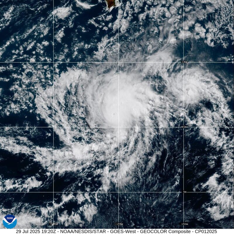
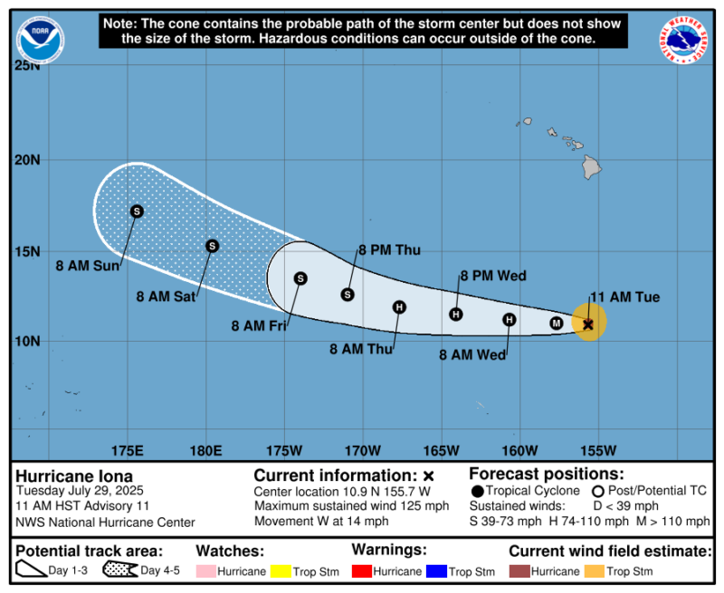
Hurricane Iona churns south of Hawaii
On the evening of Sunday, July 27, 2025, Tropical Storm Iona became the first named storm of the Central Pacific Ocean’s hurricane season. And 12 hours later – on Monday morning – it became the first hurricane of the season. By Monday night it had already strengthened into a major (category 3) hurricane, with sustained winds of 115 miles per hour. Then, by 5 a.m. Tuesday Hawaiian time (15:00 UTC), Iona had continued to rapidly strengthen, with winds speeds increasing more than 57 miles per hour within 24 hours.
The storm is now a strong category 3 hurricane with sustained winds of 125 miles per hour, according to the National Hurricane Center. Iona is more than 700 miles (1,125 km) south-southeast of Honolulu, Hawaii. And it’s moving to the west, meaning the storm will not directly impact the islands. It is also important to note that even thought Iona is very strong, its overall size is small. The hurricane-force winds of more than 74 miles per hour extend out only 30 miles (50 km) from the center of the eye. Meanwhile, the tropical storm-force winds (winds between 39 and 73 miles per hour) extend 90 miles (145 km) from the center.
While Iona could get a little stronger, it is likely at its peak intensity as it eventually moves into drier air, cooler water temperatures and stronger wind shear. This will not only keeping it from getting stronger, but it will also weaken the hurricane as it moves west.
Tropical Storm Keli
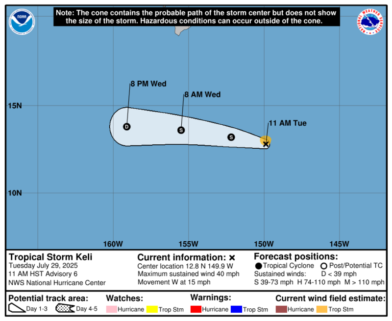
Following Hurricane Iona is the second storm of the season in the Central Pacific, Tropical Storm Keli. Keli is a much smaller and weaker storm, barely holding on to tropical storm strength with sustained winds of 40 miles per hour. Meteorologists don’t expect significant strengthening with Keli, and the storm will likely dissipate by Wednesday, July 30.
Neither tropical cyclone should have much of an impact on Hawaii’s weather. Higher swells and a slight increase in winds are possible, but otherwise the National Weather Service says Iona and Keli should have no real impact on Hawaii.
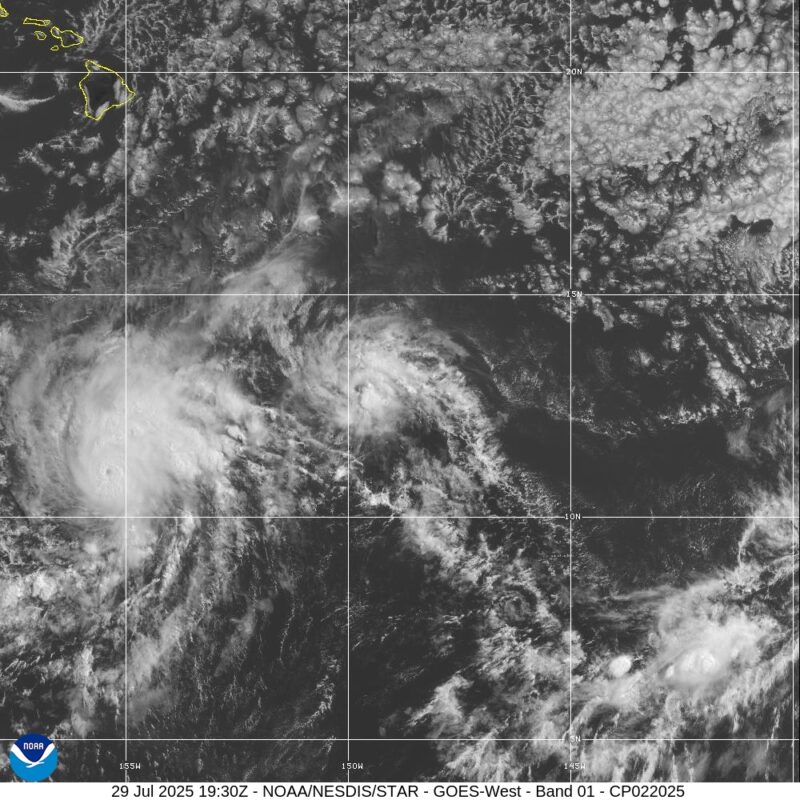
Maps for Hurricane Iona and Tropical Storm Keli
Central Pacific hurricane season
The Central Pacific hurricane season runs from June 1 through November 30, the same timeframe as the Atlantic hurricane season. But that’s where the similarities end. The Atlantic hurricane season on average has 14 named storms, 7 of which become hurricanes, and 3 major hurricanes. In comparison, the Central Pacific hurricane season typically has up to 5 tropical cyclones, which includes tropical depressions, tropical storms and hurricanes. On average, August tends to be the most active month for tropical cyclones in the Central Pacific, with 40% of observed tropical cyclones (in the 1971 through 2013 database.) occurring in this month.
The official forecast for this year’s season calls for up to 4 tropical cyclones from June 1 through November 30. It also calls for a 50% chance of a near-normal season, a 30% chance of below-normal activity, and a 20% chance of the season being more active than normal.
Neither El Niño nor La Niña
Like most tropical forecasts, the seasonal outlook for the Central Pacific can also be tied to the phase of El Niño Southern Oscillation, or ENSO. During an El Niño year, (El Niño is the warm phase of ENSO) the Central Pacific is more likely to see a slightly more active than average season, even later into the year. The latest ENSO update has the current phase as “neutral.” That means it’s neither El Niño nor La Niña, with water temperatures near-normal across the equatorial Pacific Ocean. This likely means the Central Pacific hurricane season will be tied to more localized weather patterns in addition to water temperature, wind shear and presence of dry air.
The season already has two named systems, half of the forecast of four tropical cyclones.
Bottom line: Hurricane Iona and Tropical Storm Keli are the first two tropical cyclones of the Central Pacific hurricane season. But neither should have significant impacts on Hawaii. The forecast for the Central Pacific season is for near normal with up to four tropical cyclones possible.
The post Hurricane Iona now a major hurricane, south of Hawaii first appeared on EarthSky.
from EarthSky https://ift.tt/YGZKPTs
Hurricane Iona churns south of Hawaii
On the evening of Sunday, July 27, 2025, Tropical Storm Iona became the first named storm of the Central Pacific Ocean’s hurricane season. And 12 hours later – on Monday morning – it became the first hurricane of the season. By Monday night it had already strengthened into a major (category 3) hurricane, with sustained winds of 115 miles per hour. Then, by 5 a.m. Tuesday Hawaiian time (15:00 UTC), Iona had continued to rapidly strengthen, with winds speeds increasing more than 57 miles per hour within 24 hours.
The storm is now a strong category 3 hurricane with sustained winds of 125 miles per hour, according to the National Hurricane Center. Iona is more than 700 miles (1,125 km) south-southeast of Honolulu, Hawaii. And it’s moving to the west, meaning the storm will not directly impact the islands. It is also important to note that even thought Iona is very strong, its overall size is small. The hurricane-force winds of more than 74 miles per hour extend out only 30 miles (50 km) from the center of the eye. Meanwhile, the tropical storm-force winds (winds between 39 and 73 miles per hour) extend 90 miles (145 km) from the center.
While Iona could get a little stronger, it is likely at its peak intensity as it eventually moves into drier air, cooler water temperatures and stronger wind shear. This will not only keeping it from getting stronger, but it will also weaken the hurricane as it moves west.
Tropical Storm Keli
Following Hurricane Iona is the second storm of the season in the Central Pacific, Tropical Storm Keli. Keli is a much smaller and weaker storm, barely holding on to tropical storm strength with sustained winds of 40 miles per hour. Meteorologists don’t expect significant strengthening with Keli, and the storm will likely dissipate by Wednesday, July 30.
Neither tropical cyclone should have much of an impact on Hawaii’s weather. Higher swells and a slight increase in winds are possible, but otherwise the National Weather Service says Iona and Keli should have no real impact on Hawaii.
Maps for Hurricane Iona and Tropical Storm Keli
Central Pacific hurricane season
The Central Pacific hurricane season runs from June 1 through November 30, the same timeframe as the Atlantic hurricane season. But that’s where the similarities end. The Atlantic hurricane season on average has 14 named storms, 7 of which become hurricanes, and 3 major hurricanes. In comparison, the Central Pacific hurricane season typically has up to 5 tropical cyclones, which includes tropical depressions, tropical storms and hurricanes. On average, August tends to be the most active month for tropical cyclones in the Central Pacific, with 40% of observed tropical cyclones (in the 1971 through 2013 database.) occurring in this month.
The official forecast for this year’s season calls for up to 4 tropical cyclones from June 1 through November 30. It also calls for a 50% chance of a near-normal season, a 30% chance of below-normal activity, and a 20% chance of the season being more active than normal.
Neither El Niño nor La Niña
Like most tropical forecasts, the seasonal outlook for the Central Pacific can also be tied to the phase of El Niño Southern Oscillation, or ENSO. During an El Niño year, (El Niño is the warm phase of ENSO) the Central Pacific is more likely to see a slightly more active than average season, even later into the year. The latest ENSO update has the current phase as “neutral.” That means it’s neither El Niño nor La Niña, with water temperatures near-normal across the equatorial Pacific Ocean. This likely means the Central Pacific hurricane season will be tied to more localized weather patterns in addition to water temperature, wind shear and presence of dry air.
The season already has two named systems, half of the forecast of four tropical cyclones.
Bottom line: Hurricane Iona and Tropical Storm Keli are the first two tropical cyclones of the Central Pacific hurricane season. But neither should have significant impacts on Hawaii. The forecast for the Central Pacific season is for near normal with up to four tropical cyclones possible.
The post Hurricane Iona now a major hurricane, south of Hawaii first appeared on EarthSky.
from EarthSky https://ift.tt/YGZKPTs
Aucun commentaire:
Enregistrer un commentaire