
During June 2025, dust from the Sahara Desert has been emerging off the coast of Africa over the waters of the Atlantic Ocean. While this is a phenomenon that happens every year, it has an impact on tropical storm and hurricane development, temperatures and the look of sunsets and sunrises.
What is Saharan dust?
Saharan dust, or the Saharan Air Layer (SAL) is exactly what it sounds like: dry, dusty air from the Sahara Desert. This Saharan dust develops during from spring through early fall. But it starts to get more active in the middle of June, with peak dust from late June through early August.
“Outbreaks” of Saharan dust can occur roughly every three to five days as tropical waves move from east to west along the southern edge of the Sahara Desert. As the tropical waves move west, they force the Saharan dust high into the air, creating the Saharan Air Layer. This dusty layer can move thousands of miles across the Atlantic Ocean, often reaching as far as the Caribbean, the Gulf Coast and the southeast United States. The Saharan Air Layer sits about one mile off the surface and can be up to two-and-a-half miles thick!
How does Saharan dust impact tropical weather?
Tropical cyclones, by definition, are low pressures that form over warm ocean water of at least 80 degrees Fahrenheit (27 C). But there also needs to be ample moisture stretching high into the sky. The Saharan Air Layer can be more than two miles thick. That’s two miles of dry, dusty air (which is 50% drier than the typical tropical atmosphere) stretching into the sky, cutting off moisture to the surrounding environment. When this layer moves across the Atlantic, the dry air limits the moisture in the air. So it also limits the development of tropical systems.
The Saharan Air Layer can also contain strong winds of sometimes more than 20 miles per hour. Tropical cyclones also need low wind shear to develop. Wind shear is when wind changes direction and/or speed with height. Too much wind shear can tear apart or weaken tropical cyclones. So if the Saharan Air Layer contains gusty winds, this can add wind shear to the atmosphere, also making it more difficult for tropical cyclones to develop.

Impacts on other types of weather
While forecasters typically pay close attention to the Saharan Air Layer when forecasting tropical weather, it does impact other types of non-tropical weather as well. In addition to adding dry air to the atmosphere, it warms the surrounding atmosphere as well. This warm layer stabilizes the atmosphere and helps create a sinking motion. This sinking motion doesn’t allow for the formation of clouds, let alone the formation of precipitation. This means if the Saharan dust makes it over land, it limits rain chances and allows temperatures to rise quickly, creating hot, mainly dry days.
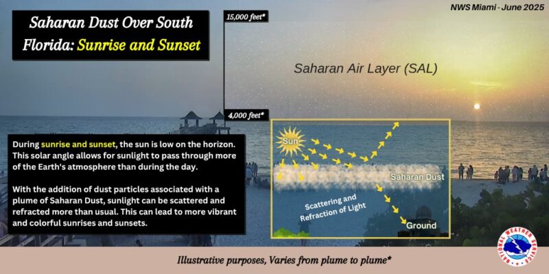
When Saharan dust reaches land, sunsets and sunrises are also extra vibrant! Light is made up of all colors of the rainbow, which are made up of long and short wavelengths. Blue colors have a shorter wavelength, while warmer colors (like yellow, orange and red) have a longer wavelength. Sunsets and sunrises in general show more red colors due to the longer wavelength of that light and color passing through more of the atmosphere when the sun is at a lower angle. When the Saharan dust is in the air, it increases this effect, creating more vivid colors as the sun rises and sets.
Bottom line: Saharan dust blows across the Atlantic Ocean every year, becoming more active in June. This dust can limit the formation of cyclones and even clouds.
Read more: NOAA forecast: Atlantic hurricane season above average in 2025
The post How Saharan dust impacts hurricanes in the Atlantic Ocean first appeared on EarthSky.
from EarthSky https://ift.tt/L9yxrpP
During June 2025, dust from the Sahara Desert has been emerging off the coast of Africa over the waters of the Atlantic Ocean. While this is a phenomenon that happens every year, it has an impact on tropical storm and hurricane development, temperatures and the look of sunsets and sunrises.
What is Saharan dust?
Saharan dust, or the Saharan Air Layer (SAL) is exactly what it sounds like: dry, dusty air from the Sahara Desert. This Saharan dust develops during from spring through early fall. But it starts to get more active in the middle of June, with peak dust from late June through early August.
“Outbreaks” of Saharan dust can occur roughly every three to five days as tropical waves move from east to west along the southern edge of the Sahara Desert. As the tropical waves move west, they force the Saharan dust high into the air, creating the Saharan Air Layer. This dusty layer can move thousands of miles across the Atlantic Ocean, often reaching as far as the Caribbean, the Gulf Coast and the southeast United States. The Saharan Air Layer sits about one mile off the surface and can be up to two-and-a-half miles thick!
How does Saharan dust impact tropical weather?
Tropical cyclones, by definition, are low pressures that form over warm ocean water of at least 80 degrees Fahrenheit (27 C). But there also needs to be ample moisture stretching high into the sky. The Saharan Air Layer can be more than two miles thick. That’s two miles of dry, dusty air (which is 50% drier than the typical tropical atmosphere) stretching into the sky, cutting off moisture to the surrounding environment. When this layer moves across the Atlantic, the dry air limits the moisture in the air. So it also limits the development of tropical systems.
The Saharan Air Layer can also contain strong winds of sometimes more than 20 miles per hour. Tropical cyclones also need low wind shear to develop. Wind shear is when wind changes direction and/or speed with height. Too much wind shear can tear apart or weaken tropical cyclones. So if the Saharan Air Layer contains gusty winds, this can add wind shear to the atmosphere, also making it more difficult for tropical cyclones to develop.
Impacts on other types of weather
While forecasters typically pay close attention to the Saharan Air Layer when forecasting tropical weather, it does impact other types of non-tropical weather as well. In addition to adding dry air to the atmosphere, it warms the surrounding atmosphere as well. This warm layer stabilizes the atmosphere and helps create a sinking motion. This sinking motion doesn’t allow for the formation of clouds, let alone the formation of precipitation. This means if the Saharan dust makes it over land, it limits rain chances and allows temperatures to rise quickly, creating hot, mainly dry days.
When Saharan dust reaches land, sunsets and sunrises are also extra vibrant! Light is made up of all colors of the rainbow, which are made up of long and short wavelengths. Blue colors have a shorter wavelength, while warmer colors (like yellow, orange and red) have a longer wavelength. Sunsets and sunrises in general show more red colors due to the longer wavelength of that light and color passing through more of the atmosphere when the sun is at a lower angle. When the Saharan dust is in the air, it increases this effect, creating more vivid colors as the sun rises and sets.
Bottom line: Saharan dust blows across the Atlantic Ocean every year, becoming more active in June. This dust can limit the formation of cyclones and even clouds.
Read more: NOAA forecast: Atlantic hurricane season above average in 2025
The post How Saharan dust impacts hurricanes in the Atlantic Ocean first appeared on EarthSky.
from EarthSky https://ift.tt/L9yxrpP
Aucun commentaire:
Enregistrer un commentaire