What are cumulonimbus clouds?
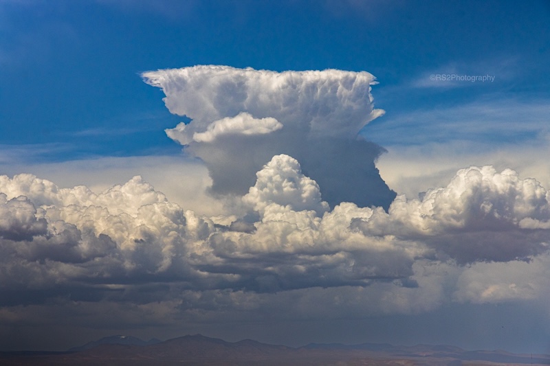
Cumulonimbus clouds are among the most awe-inspiring cloud formations. They can tower for miles into the sky, bumping into the stratosphere and flattening out in an anvil shape on top. Cumulonimbus clouds are sometimes called thunderheads, because they’re the engines behind thunderstorms, severe weather and even tornadoes. If you see a cumulonimbus cloud bubbling upward into the sky, get ready to take cover.
The word cumulonimbus comes from the Latin cumulo meaning heap or pile and nimbus meaning cloud. They begin as the puffy white cumulus clouds that can rapidly grow under the right conditions. Their bases near the ground can be as low as 1,000 meters (3,300 feet) and their tops can reach up to 12,000 meters (39,000 feet, 7+ miles!) or more.
How do they form?
The formation of a cumulonimbus cloud begins with convection. Convection is when warm air rises, because it’s less dense than the cooler air around it. And convection happens on warm days when Earth’s surface heats unevenly, such as in the afternoon over land. As the warm, moist air rises, it cools and condenses, forming puffy cumulus clouds.
If the rising air continues to be warmer than its surroundings, it will keep growing, forming larger and taller clouds. When the atmosphere is particularly unstable – meaning that temperature decreases rapidly with height – this upward motion becomes more vigorous. In this case, a cumulus cloud can quickly grow into a cumulonimbus cloud.
Inside a developing cumulonimbus cloud, there are both updrafts and downdrafts. The winds of the updrafts can reach speeds of more than 100 mph (45 m/s). These updrafts carry water vapor high into the atmosphere, where it condenses into water droplets or ice crystals. And this releases latent heat, fueling further cloud growth. The top of the cloud eventually flattens out when it hits the tropopause, the divider between the lower troposphere and the higher stratosphere.
Watch this time lapse of cumulus clouds growing into a towering cumulonimbus cloud with an anvil top.
When and where do you see cumulonimbus clouds?
Cumulonimbus clouds can form anywhere in the world. However, they’re most common in regions where warm, moist air is prevalent. In the United States, for instance, you can frequently see these clouds in the spring and summer months. This is especially true for the Great Plains, Midwest and Southeast, where warm, humid air from the Gulf of Mexico interacts with cooler air masses. But you can also see these clouds nearly every summer afternoon in central Florida, thanks to sea breezes and lots of tropical moisture.
You are most likely to see cumulonimbus clouds in the afternoon and early evening, when surface heating from the sun is at its peak. But they can also occur at other times of the day or night.
What kind of weather do cumulonimbus clouds bring?
Cumulonimbus clouds are synonymous with severe weather. They are the primary cloud type responsible for thunderstorms.
Depending on their intensity and the conditions around them, cumulonimbus clouds can produce:
- Torrential rain: Localized downpours that can lead to flash flooding.
- Hail: Ice particles carried in updrafts and downdrafts, growing larger before falling to the ground.
- Strong winds: Often associated with downdrafts or microbursts, which can cause damage similar to weak tornadoes.
- Tornadoes: In the most severe storms, rotating updrafts can spawn tornadoes.
- Lightning: Electrical charges can trigger lightning within the cloud and also send bolts careening to the ground.
Due to all these hazards, airplanes fly around and not through cumulonimbus clouds.
In this video, you can see air traffic diverting around cumulonimbus clouds and then circling, waiting for the storms to clear the Atlanta airport before landing.
Stay safe
Always remember safety when you see a cumulonimbus cloud. The lightning from these clouds can strike miles away, far from where the cloud is producing rain. Hail can be dangerous for people and animals without shelter. Torrential rain can cause flash flooding, and strong winds and tornadoes can send objects flying.
Cumulonimbus clouds are awe-inspiring and formidable phenomena that remind us of nature’s raw power. Spotting a cumulonimbus cloud offers us a glimpse into the dynamic processes of the atmosphere. And it provides a warning of the powerful forces brewing above.
If you catch a great image of a cumulonimbus cloud, submit it to us!
Bottom line: Cumulonimbus clouds, sometimes called thunderheads, are towering formations that can bring severe storms such as hail, lightning, flooding and tornadoes.
Read more:
Cloud shapes are a useful tool for predicting weather
Media we love: The book A Cloud a Day
Bumpy flight? Here’s how clouds affect air travel
The post Cumulonimbus clouds bring thunderstorms: How to spot them first appeared on EarthSky.
from EarthSky https://ift.tt/n6RBX02
What are cumulonimbus clouds?
Cumulonimbus clouds are among the most awe-inspiring cloud formations. They can tower for miles into the sky, bumping into the stratosphere and flattening out in an anvil shape on top. Cumulonimbus clouds are sometimes called thunderheads, because they’re the engines behind thunderstorms, severe weather and even tornadoes. If you see a cumulonimbus cloud bubbling upward into the sky, get ready to take cover.
The word cumulonimbus comes from the Latin cumulo meaning heap or pile and nimbus meaning cloud. They begin as the puffy white cumulus clouds that can rapidly grow under the right conditions. Their bases near the ground can be as low as 1,000 meters (3,300 feet) and their tops can reach up to 12,000 meters (39,000 feet, 7+ miles!) or more.
How do they form?
The formation of a cumulonimbus cloud begins with convection. Convection is when warm air rises, because it’s less dense than the cooler air around it. And convection happens on warm days when Earth’s surface heats unevenly, such as in the afternoon over land. As the warm, moist air rises, it cools and condenses, forming puffy cumulus clouds.
If the rising air continues to be warmer than its surroundings, it will keep growing, forming larger and taller clouds. When the atmosphere is particularly unstable – meaning that temperature decreases rapidly with height – this upward motion becomes more vigorous. In this case, a cumulus cloud can quickly grow into a cumulonimbus cloud.
Inside a developing cumulonimbus cloud, there are both updrafts and downdrafts. The winds of the updrafts can reach speeds of more than 100 mph (45 m/s). These updrafts carry water vapor high into the atmosphere, where it condenses into water droplets or ice crystals. And this releases latent heat, fueling further cloud growth. The top of the cloud eventually flattens out when it hits the tropopause, the divider between the lower troposphere and the higher stratosphere.
Watch this time lapse of cumulus clouds growing into a towering cumulonimbus cloud with an anvil top.
When and where do you see cumulonimbus clouds?
Cumulonimbus clouds can form anywhere in the world. However, they’re most common in regions where warm, moist air is prevalent. In the United States, for instance, you can frequently see these clouds in the spring and summer months. This is especially true for the Great Plains, Midwest and Southeast, where warm, humid air from the Gulf of Mexico interacts with cooler air masses. But you can also see these clouds nearly every summer afternoon in central Florida, thanks to sea breezes and lots of tropical moisture.
You are most likely to see cumulonimbus clouds in the afternoon and early evening, when surface heating from the sun is at its peak. But they can also occur at other times of the day or night.
What kind of weather do cumulonimbus clouds bring?
Cumulonimbus clouds are synonymous with severe weather. They are the primary cloud type responsible for thunderstorms.
Depending on their intensity and the conditions around them, cumulonimbus clouds can produce:
- Torrential rain: Localized downpours that can lead to flash flooding.
- Hail: Ice particles carried in updrafts and downdrafts, growing larger before falling to the ground.
- Strong winds: Often associated with downdrafts or microbursts, which can cause damage similar to weak tornadoes.
- Tornadoes: In the most severe storms, rotating updrafts can spawn tornadoes.
- Lightning: Electrical charges can trigger lightning within the cloud and also send bolts careening to the ground.
Due to all these hazards, airplanes fly around and not through cumulonimbus clouds.
In this video, you can see air traffic diverting around cumulonimbus clouds and then circling, waiting for the storms to clear the Atlanta airport before landing.
Stay safe
Always remember safety when you see a cumulonimbus cloud. The lightning from these clouds can strike miles away, far from where the cloud is producing rain. Hail can be dangerous for people and animals without shelter. Torrential rain can cause flash flooding, and strong winds and tornadoes can send objects flying.
Cumulonimbus clouds are awe-inspiring and formidable phenomena that remind us of nature’s raw power. Spotting a cumulonimbus cloud offers us a glimpse into the dynamic processes of the atmosphere. And it provides a warning of the powerful forces brewing above.
If you catch a great image of a cumulonimbus cloud, submit it to us!
Bottom line: Cumulonimbus clouds, sometimes called thunderheads, are towering formations that can bring severe storms such as hail, lightning, flooding and tornadoes.
Read more:
Cloud shapes are a useful tool for predicting weather
Media we love: The book A Cloud a Day
Bumpy flight? Here’s how clouds affect air travel
The post Cumulonimbus clouds bring thunderstorms: How to spot them first appeared on EarthSky.
from EarthSky https://ift.tt/n6RBX02
Aucun commentaire:
Enregistrer un commentaire