Tropical Storm Debby heading to Florida
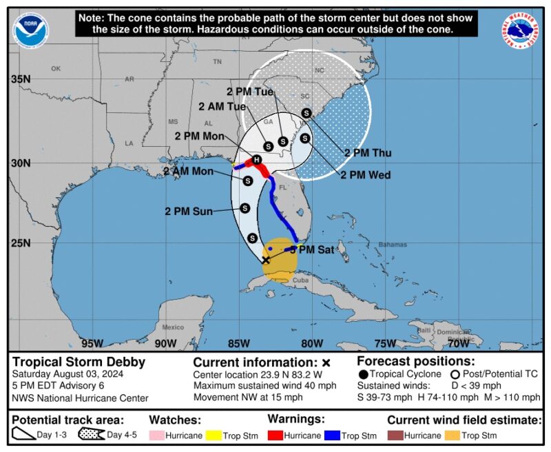
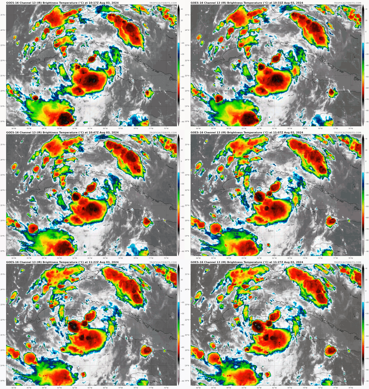
A tropical depression strengthened into Tropical Storm Debby in the Gulf of Mexico on Saturday afternoon, August 3, 2024. The center of circulation moved off Cuba and over the very warm waters of the Gulf of Mexico. Those warm waters and low shear have helped it strengthen into a named storm. Forecasters said it’s likely the storm will become a hurricane before landfall on Monday.
Much of the west coast of Florida is under hurricane or tropical storm warnings, along with storm surge warnings. Winds will start coming ashore in Florida on Sunday afternoon. On Saturday afternoon, Debby’s maximum sustained winds were 40 miles per hour. The threshold for hurricane status is 74 miles per hour, and forecasters believe it will likely reach those speeds before landfall on Monday.
Biggest impact will be rain
The biggest impact from Tropical Storm Debby will be the rain. Meteorologists are calling for some 4 to 7 feet of inundation along the coastline of Florida’s Big Bend when the storm comes on shore Monday morning. Some coastal areas could be evacuated.
Florida and the lower Atlantic seaboard could see heavy rainfall totals starting this weekend and extending all the way into Thursday, August 8, 2024. Forecasters are calling for some totals of 5 to 10 inches, with local areas seeing up to 15 inches of rain. The heavy rains will extend up to North Carolina. Residents also need to be aware of the threat of flash flooding.
The storm’s path will take it from the Gulf of Mexico across northern regions of Florida and then toward the eastern seaboard. But after it moves over land, Debby will slow down. So some regions will deal with heavy rainfall for a long period of time.
Storm-force winds
The strong winds will first hit along Florida’s Gulf Coast near the Big Bend region on Sunday late in the day. The eye should come ashore on Monday morning. Then Debby will linger over the southeastern U.S., but the strength of its winds will be dependent on whether the storm stays over land or moves back over water. However, due to its slow motion, this part of the U.S. should expect gusty winds for days.
And of course with the tropical storm, there are chances for tornado spin-ups. Make sure you stay weather aware if you will be in the affected area.
On Saturday afternoon, the National Hurricane Center shared an update on their YouTube channel that you can watch here.
Visit this link for a handy visualization of the winds.

Bottom line: A tropical depression strengthened into Tropical Storm Debby in the Gulf of Mexico on Saturday. It may reach hurricane strength before hitting Florida on Monday.
Read more: Will La Niña pump up this year’s hurricane season?
The post Tropical Storm Debby will hit Florida, likely as a hurricane first appeared on EarthSky.
from EarthSky https://ift.tt/Vyc6jBJ

Tropical Storm Debby heading to Florida
A tropical depression strengthened into Tropical Storm Debby in the Gulf of Mexico on Saturday afternoon, August 3, 2024. The center of circulation moved off Cuba and over the very warm waters of the Gulf of Mexico. Those warm waters and low shear have helped it strengthen into a named storm. Forecasters said it’s likely the storm will become a hurricane before landfall on Monday.
Much of the west coast of Florida is under hurricane or tropical storm warnings, along with storm surge warnings. Winds will start coming ashore in Florida on Sunday afternoon. On Saturday afternoon, Debby’s maximum sustained winds were 40 miles per hour. The threshold for hurricane status is 74 miles per hour, and forecasters believe it will likely reach those speeds before landfall on Monday.
Biggest impact will be rain
The biggest impact from Tropical Storm Debby will be the rain. Meteorologists are calling for some 4 to 7 feet of inundation along the coastline of Florida’s Big Bend when the storm comes on shore Monday morning. Some coastal areas could be evacuated.
Florida and the lower Atlantic seaboard could see heavy rainfall totals starting this weekend and extending all the way into Thursday, August 8, 2024. Forecasters are calling for some totals of 5 to 10 inches, with local areas seeing up to 15 inches of rain. The heavy rains will extend up to North Carolina. Residents also need to be aware of the threat of flash flooding.
The storm’s path will take it from the Gulf of Mexico across northern regions of Florida and then toward the eastern seaboard. But after it moves over land, Debby will slow down. So some regions will deal with heavy rainfall for a long period of time.
Storm-force winds
The strong winds will first hit along Florida’s Gulf Coast near the Big Bend region on Sunday late in the day. The eye should come ashore on Monday morning. Then Debby will linger over the southeastern U.S., but the strength of its winds will be dependent on whether the storm stays over land or moves back over water. However, due to its slow motion, this part of the U.S. should expect gusty winds for days.
And of course with the tropical storm, there are chances for tornado spin-ups. Make sure you stay weather aware if you will be in the affected area.
On Saturday afternoon, the National Hurricane Center shared an update on their YouTube channel that you can watch here.
Visit this link for a handy visualization of the winds.

Bottom line: A tropical depression strengthened into Tropical Storm Debby in the Gulf of Mexico on Saturday. It may reach hurricane strength before hitting Florida on Monday.
Read more: Will La Niña pump up this year’s hurricane season?
The post Tropical Storm Debby will hit Florida, likely as a hurricane first appeared on EarthSky.
from EarthSky https://ift.tt/Vyc6jBJ

Aucun commentaire:
Enregistrer un commentaire