Rain, snow and winds coming to California
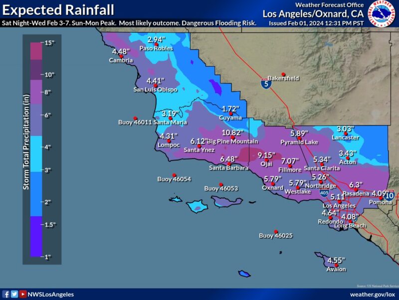
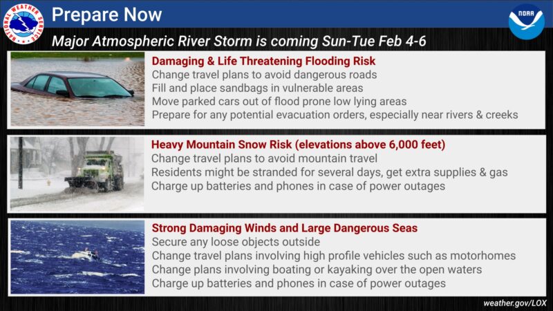
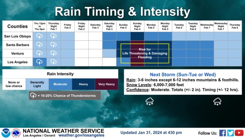
California is bracing for an onslaught of rain, strong winds and snow at higher elevations. An atmospheric river will bring the storm ashore starting Saturday night (February 3, 2024) with highest rainfall amounts falling Sunday and Monday. Some areas could see close to a foot of rain.
Officials have issued an evacuation warning for part of Santa Barbara County.
?? EVACUATION WARNINGS have been issued for parts of Santa Barbara County. These EVACUATION WARNINGS are due to an incoming storm arriving Saturday, February 3 through Tuesday, February 5.
? Info: https://t.co/iGQy84pGay pic.twitter.com/rDZTAwboVI— SBCountyOEM (@SBCountyOEM) February 2, 2024
California has had a lower-than-average snowpack this season. It’s been too warm to snow, but this coming week the state will make up a little of the deficit at higher altitudes with the incoming storm. Mountainous area could see up to 6 feet of snow by Thursday, February 7.
California and the Pacific Northwest have already seen a lot of rain over the past week, as another atmospheric river hit the West Coast.
A lot of people are in the crosshairs of this atmospheric river. According to the Public Policy Institute of California, one in eight U.S. residents lives in California. And the population of just Southern California is more than 23 million.
What is an atmospheric river?
An atmospheric river is a long, narrow band of water vapor in the lowest part of the atmosphere. It’s like a river in the sky that releases precipitation when it hits the coast and mountains. When it encounters these landforms, the atmospheric river gets pushed upward, causing the water vapor to condense (change from a gas to a liquid) and fall to the ground. According to the USGS:
Up to 50% of California’s annual precipitation can come from atmospheric rivers.
Back-to-back atmospheric rivers make for a high flood risk. As The Conversation explained:
The first heavy downpours saturate the ground. As consecutive storms arrive, their precipitation falls on soil that can’t absorb more water. That contributes to more runoff. Rivers and streams fill up.
A historic nine consecutive atmospheric rivers hit California last winter, helping refill the reservoirs in the state. But they also brought flooding and mudslides.
The next atmospheric river takes shape in the eastern Pacific Ocean.
Heavy precipitation is expected in parts of California as soon as late Saturday night. pic.twitter.com/TebSJhNQ5B
— CIRA (@CIRA_CSU) February 2, 2024
Warnings from the NWS
Bottom line: An atmospheric river is poised to hit California, bringing rain, wind and heavy snowfall at high altitudes. The National Weather Service warns people to take preparations.
The post Atmospheric river aimed for California, floods likely first appeared on EarthSky.
from EarthSky https://ift.tt/plWD6EK
Rain, snow and winds coming to California
California is bracing for an onslaught of rain, strong winds and snow at higher elevations. An atmospheric river will bring the storm ashore starting Saturday night (February 3, 2024) with highest rainfall amounts falling Sunday and Monday. Some areas could see close to a foot of rain.
Officials have issued an evacuation warning for part of Santa Barbara County.
?? EVACUATION WARNINGS have been issued for parts of Santa Barbara County. These EVACUATION WARNINGS are due to an incoming storm arriving Saturday, February 3 through Tuesday, February 5.
? Info: https://t.co/iGQy84pGay pic.twitter.com/rDZTAwboVI— SBCountyOEM (@SBCountyOEM) February 2, 2024
California has had a lower-than-average snowpack this season. It’s been too warm to snow, but this coming week the state will make up a little of the deficit at higher altitudes with the incoming storm. Mountainous area could see up to 6 feet of snow by Thursday, February 7.
California and the Pacific Northwest have already seen a lot of rain over the past week, as another atmospheric river hit the West Coast.
A lot of people are in the crosshairs of this atmospheric river. According to the Public Policy Institute of California, one in eight U.S. residents lives in California. And the population of just Southern California is more than 23 million.
What is an atmospheric river?
An atmospheric river is a long, narrow band of water vapor in the lowest part of the atmosphere. It’s like a river in the sky that releases precipitation when it hits the coast and mountains. When it encounters these landforms, the atmospheric river gets pushed upward, causing the water vapor to condense (change from a gas to a liquid) and fall to the ground. According to the USGS:
Up to 50% of California’s annual precipitation can come from atmospheric rivers.
Back-to-back atmospheric rivers make for a high flood risk. As The Conversation explained:
The first heavy downpours saturate the ground. As consecutive storms arrive, their precipitation falls on soil that can’t absorb more water. That contributes to more runoff. Rivers and streams fill up.
A historic nine consecutive atmospheric rivers hit California last winter, helping refill the reservoirs in the state. But they also brought flooding and mudslides.
The next atmospheric river takes shape in the eastern Pacific Ocean.
Heavy precipitation is expected in parts of California as soon as late Saturday night. pic.twitter.com/TebSJhNQ5B
— CIRA (@CIRA_CSU) February 2, 2024
Warnings from the NWS
Bottom line: An atmospheric river is poised to hit California, bringing rain, wind and heavy snowfall at high altitudes. The National Weather Service warns people to take preparations.
The post Atmospheric river aimed for California, floods likely first appeared on EarthSky.
from EarthSky https://ift.tt/plWD6EK
Aucun commentaire:
Enregistrer un commentaire