Looks like another smoke filled day across the northeast with a fresh batch from Quebec according to the HRRR. Poor air quality will result in areas of dense concentrations. pic.twitter.com/cNMdkqQHk9
— Jim Cantore (@JimCantore) June 6, 2023
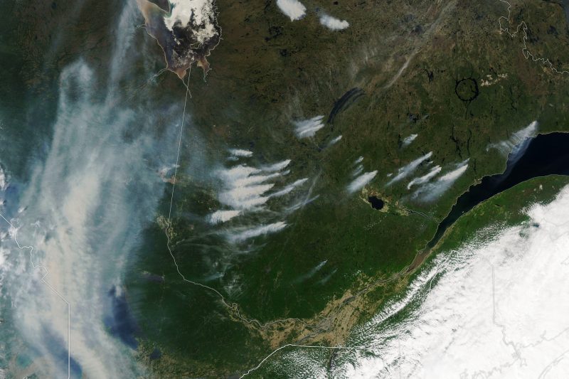
Canadian wildfire smoke covers northeastern U.S.
The Northeastern United States is suffering from hazy skies and poor air quality due to wildfires in Quebec, Canada. NASA’s Earth Observatory said that lightning sparked some of these wildfires. And Quebec’s fire prevention agency said that in an average year, they see about 300 hectares burned by this time of year, but this year, more than 226,000 hectares (872 square miles) have already burned. The Weather Channel’s Jim Cantore also said that the wildfire smoke should affect the United States for the rest of the week, with concentrations going up and down.
When under an air quality alert, people should consider modifying their activities and spending less time outdoors. It’s okay to skip that long run or move it indoors to a treadmill. Sensitive groups (children, the elderly, those with asthma, for example) may experience more serious health effects. You can check the map here to see which areas are under air quality alerts.
The wildfire season in western Canada also got off to a bang earlier this year, with smoke from these fires affecting the U.S. as well.
A look at the Canadian wildfire smoke
Here is the big picture view of Canadian wildfire #smoke today followed by 2 zooms. The first two segments depict vertically integrated smoke – much of which is aloft. The last loop depicts near surface smoke, which impacts #AirQuality and human health. https://t.co/h4zcGudRJ2 pic.twitter.com/NAPOvtbUYQ
— UW-Madison CIMSS (@UWCIMSS) June 6, 2023
Good morning NYC obscured by smoke! Smoke from wildfires in Canada is taking over the northeast and will spread near surface smoke all the way into Kentucky & North Carolina today. Stagnant pattern. #smoke #fires #hazy @Wx_Max @KentonGewecke photo @EarthCam pic.twitter.com/VdeY3NDWFA
— Ginger Zee (@Ginger_Zee) June 6, 2023
Fire danger in parts of the Northeast
And – to add fuel to the fire – portions of the Northeast are under an alert for critical fire weather from Michigan into Pennsylvania and New Jersey. On June 6, 2023, NOAA’s Storm Prediction Center said the Northeast would have:
… dry and breezy conditions favorable for wildfire-spread, along with the highly unusual chance of some dry lightning strikes in the Mid Atlantic.
Dry lightning and dry thunderstorms in the forecast today across a dry part of the northeast. Hopefully we won't be adding smoke to the smoke. pic.twitter.com/KJdr0V44GT
— Jim Cantore (@JimCantore) June 6, 2023
2:08am CDT #SPC Day1 #FireWX Critical: for portions of eastern pennsylvania into new jersey https://t.co/Sz3kci5V5F pic.twitter.com/kJcl1mwMBb
— NWS Storm Prediction Center (@NWSSPC) June 6, 2023
Apocalyptic scenes in the Northeast
The wildfire smoke is affecting the skies and air quality for millions of people in the Northeast. From milky colored skies to red suns and moons, residents have been taking notice.
New York City covered in thick smoke from the Quebec wildfires this morning! The current Air Quality Index for the city is 158, which is in the “unhealthy” category. #NYwx pic.twitter.com/6d2usZJQLa
— Collin Gross (@CollinGrossWx) June 6, 2023
The wildfire smoke is so bad this morning in New York City you cannot see the sunrise. At all. Probably the worst I've ever seen it. pic.twitter.com/gRgRvKRluV
— Nicholas Isabella (@NycStormChaser) June 6, 2023
More wildfire smoke
Other northern regions of the U.S. and, of course, parts of Canada are dealing with the wildfire smoke as well.
This isn’t a solar eclipse. ? The smoke particles from #wildfires throughout Canada allow sunlight's longer wavelength colors like red and orange to get through while blocking the shorter wavelengths of yellow, blue and green. pic.twitter.com/cFm2msOg8H
— Canadian Space Agency (@csa_asc) June 6, 2023
Check out this shot from News Chopper 12! That's not fog, it's smoke from wildfires burning in Canada.
Visibility is reduced, and air quality is being impacted (especially for those with respiratory conditions) this morning. pic.twitter.com/WmNLmKsYti
— Molly Bernard (@Molly_WISN) June 6, 2023
Descending through the wildfire smoke into O’Hare today. pic.twitter.com/pFGFkj7hUG
— Kelly Kizer Whitt (@Astronomommy) June 5, 2023
Bottom line: Canadian wildfire smoke pouring across the border is turning skies milky white in the northeastern U.S. Poor air quality will remain in these regions for much of the week.
The post Canadian wildfire smoke covers northeastern US first appeared on EarthSky.
from EarthSky https://ift.tt/UEXoStR
Looks like another smoke filled day across the northeast with a fresh batch from Quebec according to the HRRR. Poor air quality will result in areas of dense concentrations. pic.twitter.com/cNMdkqQHk9
— Jim Cantore (@JimCantore) June 6, 2023
Canadian wildfire smoke covers northeastern U.S.
The Northeastern United States is suffering from hazy skies and poor air quality due to wildfires in Quebec, Canada. NASA’s Earth Observatory said that lightning sparked some of these wildfires. And Quebec’s fire prevention agency said that in an average year, they see about 300 hectares burned by this time of year, but this year, more than 226,000 hectares (872 square miles) have already burned. The Weather Channel’s Jim Cantore also said that the wildfire smoke should affect the United States for the rest of the week, with concentrations going up and down.
When under an air quality alert, people should consider modifying their activities and spending less time outdoors. It’s okay to skip that long run or move it indoors to a treadmill. Sensitive groups (children, the elderly, those with asthma, for example) may experience more serious health effects. You can check the map here to see which areas are under air quality alerts.
The wildfire season in western Canada also got off to a bang earlier this year, with smoke from these fires affecting the U.S. as well.
A look at the Canadian wildfire smoke
Here is the big picture view of Canadian wildfire #smoke today followed by 2 zooms. The first two segments depict vertically integrated smoke – much of which is aloft. The last loop depicts near surface smoke, which impacts #AirQuality and human health. https://t.co/h4zcGudRJ2 pic.twitter.com/NAPOvtbUYQ
— UW-Madison CIMSS (@UWCIMSS) June 6, 2023
Good morning NYC obscured by smoke! Smoke from wildfires in Canada is taking over the northeast and will spread near surface smoke all the way into Kentucky & North Carolina today. Stagnant pattern. #smoke #fires #hazy @Wx_Max @KentonGewecke photo @EarthCam pic.twitter.com/VdeY3NDWFA
— Ginger Zee (@Ginger_Zee) June 6, 2023
Fire danger in parts of the Northeast
And – to add fuel to the fire – portions of the Northeast are under an alert for critical fire weather from Michigan into Pennsylvania and New Jersey. On June 6, 2023, NOAA’s Storm Prediction Center said the Northeast would have:
… dry and breezy conditions favorable for wildfire-spread, along with the highly unusual chance of some dry lightning strikes in the Mid Atlantic.
Dry lightning and dry thunderstorms in the forecast today across a dry part of the northeast. Hopefully we won't be adding smoke to the smoke. pic.twitter.com/KJdr0V44GT
— Jim Cantore (@JimCantore) June 6, 2023
2:08am CDT #SPC Day1 #FireWX Critical: for portions of eastern pennsylvania into new jersey https://t.co/Sz3kci5V5F pic.twitter.com/kJcl1mwMBb
— NWS Storm Prediction Center (@NWSSPC) June 6, 2023
Apocalyptic scenes in the Northeast
The wildfire smoke is affecting the skies and air quality for millions of people in the Northeast. From milky colored skies to red suns and moons, residents have been taking notice.
New York City covered in thick smoke from the Quebec wildfires this morning! The current Air Quality Index for the city is 158, which is in the “unhealthy” category. #NYwx pic.twitter.com/6d2usZJQLa
— Collin Gross (@CollinGrossWx) June 6, 2023
The wildfire smoke is so bad this morning in New York City you cannot see the sunrise. At all. Probably the worst I've ever seen it. pic.twitter.com/gRgRvKRluV
— Nicholas Isabella (@NycStormChaser) June 6, 2023
More wildfire smoke
Other northern regions of the U.S. and, of course, parts of Canada are dealing with the wildfire smoke as well.
This isn’t a solar eclipse. ? The smoke particles from #wildfires throughout Canada allow sunlight's longer wavelength colors like red and orange to get through while blocking the shorter wavelengths of yellow, blue and green. pic.twitter.com/cFm2msOg8H
— Canadian Space Agency (@csa_asc) June 6, 2023
Check out this shot from News Chopper 12! That's not fog, it's smoke from wildfires burning in Canada.
Visibility is reduced, and air quality is being impacted (especially for those with respiratory conditions) this morning. pic.twitter.com/WmNLmKsYti
— Molly Bernard (@Molly_WISN) June 6, 2023
Descending through the wildfire smoke into O’Hare today. pic.twitter.com/pFGFkj7hUG
— Kelly Kizer Whitt (@Astronomommy) June 5, 2023
Bottom line: Canadian wildfire smoke pouring across the border is turning skies milky white in the northeastern U.S. Poor air quality will remain in these regions for much of the week.
The post Canadian wildfire smoke covers northeastern US first appeared on EarthSky.
from EarthSky https://ift.tt/UEXoStR
Aucun commentaire:
Enregistrer un commentaire