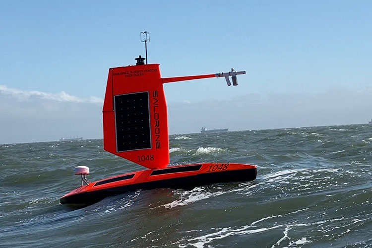
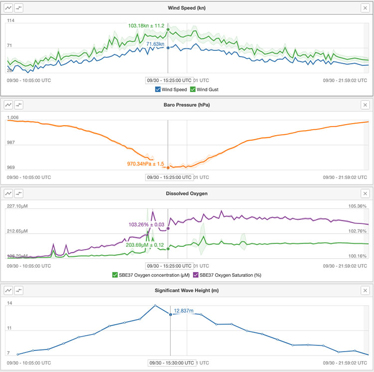
For the first time ever, an ocean drone has gone inside a hurricane and sent back video. This ocean drone, a 23-foot-long Saildrone Explorer SD 1045, entered the furious category-4 winds of Hurricane Sam on September 30, 2021, as it swirled in the Atlantic Ocean. The Saildrone sent back footage of 50-foot waves stirred up by 120-mile-per-hour (190 kph) winds. The resulting videos of the tempest-tossed ocean could make even those watching on solid ground feel a little seasick.
Ocean drone explores Hurricane Sam

Saildrone Inc. and the National Oceanic and Atmospheric Administration (NOAA) partnered together to put the ocean drone into the core of the hurricane in the hopes of gaining data to better forecast dangerous storms. Not one but five ocean drones are floating in key areas of the Atlantic Ocean where storms historically occur. The organizations eventually hope to have an even larger fleet out monitoring the ocean.
The ocean drones are equipped with a hurricane wing. The hurricane wing provides stability for these drones to operate on ravaged waters and in extremely windy conditions. The data the drones collect may help scientists understand how tropical storms grow and intensify. NOAA scientist Greg Foltz said:
Using data collected by saildrones, we expect to improve forecast models that predict rapid intensification of hurricanes. Rapid intensification, when hurricane winds strengthen in a matter of hours, is a serious threat to coastal communities. New data from saildrones and other uncrewed systems that NOAA is using will help us better predict the forces that drive hurricanes and be able to warn communities earlier.
Sending back crucial data
All five saildrones currently in the Atlantic are sending back realtime data. The drones provide information on air temperature, relative humidity, barometric pressure, wind speed and direction, water temperature and salinity, sea surface temperature, and wave height and period. The drones share this information with 20 agencies worldwide.

More video from inside Hurricane Sam
Richard Jenkins, Saildrone founder and CEO, said:
Saildrone is going where no research vessel has ever ventured, sailing right into the eye of the hurricane, gathering data that will transform our understanding of these powerful storms. After conquering the Arctic and the Southern Ocean, hurricanes were the last frontier for Saildrone survivability. We are proud to have engineered a vehicle capable of operating in the most extreme weather conditions on earth.
Bottom line: An ocean drone entered a powerful hurricane churning in the Atlantic Ocean on September 30, 2021. It sent back the first video from a sailing drone taken inside a hurricane.
The post 1st ocean drone video from inside a hurricane first appeared on EarthSky.
from EarthSky https://ift.tt/3mqAPXF
For the first time ever, an ocean drone has gone inside a hurricane and sent back video. This ocean drone, a 23-foot-long Saildrone Explorer SD 1045, entered the furious category-4 winds of Hurricane Sam on September 30, 2021, as it swirled in the Atlantic Ocean. The Saildrone sent back footage of 50-foot waves stirred up by 120-mile-per-hour (190 kph) winds. The resulting videos of the tempest-tossed ocean could make even those watching on solid ground feel a little seasick.
Ocean drone explores Hurricane Sam

Saildrone Inc. and the National Oceanic and Atmospheric Administration (NOAA) partnered together to put the ocean drone into the core of the hurricane in the hopes of gaining data to better forecast dangerous storms. Not one but five ocean drones are floating in key areas of the Atlantic Ocean where storms historically occur. The organizations eventually hope to have an even larger fleet out monitoring the ocean.
The ocean drones are equipped with a hurricane wing. The hurricane wing provides stability for these drones to operate on ravaged waters and in extremely windy conditions. The data the drones collect may help scientists understand how tropical storms grow and intensify. NOAA scientist Greg Foltz said:
Using data collected by saildrones, we expect to improve forecast models that predict rapid intensification of hurricanes. Rapid intensification, when hurricane winds strengthen in a matter of hours, is a serious threat to coastal communities. New data from saildrones and other uncrewed systems that NOAA is using will help us better predict the forces that drive hurricanes and be able to warn communities earlier.
Sending back crucial data
All five saildrones currently in the Atlantic are sending back realtime data. The drones provide information on air temperature, relative humidity, barometric pressure, wind speed and direction, water temperature and salinity, sea surface temperature, and wave height and period. The drones share this information with 20 agencies worldwide.

More video from inside Hurricane Sam
Richard Jenkins, Saildrone founder and CEO, said:
Saildrone is going where no research vessel has ever ventured, sailing right into the eye of the hurricane, gathering data that will transform our understanding of these powerful storms. After conquering the Arctic and the Southern Ocean, hurricanes were the last frontier for Saildrone survivability. We are proud to have engineered a vehicle capable of operating in the most extreme weather conditions on earth.
Bottom line: An ocean drone entered a powerful hurricane churning in the Atlantic Ocean on September 30, 2021. It sent back the first video from a sailing drone taken inside a hurricane.
The post 1st ocean drone video from inside a hurricane first appeared on EarthSky.
from EarthSky https://ift.tt/3mqAPXF

Aucun commentaire:
Enregistrer un commentaire