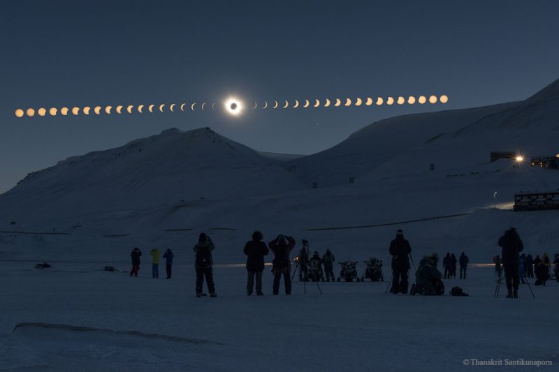
Total solar eclipse
A total solar eclipse sweeps across Antarctica on December 4, 2021. People located at the southernmost tips of South America, Africa, Australia and New Zealand will experience the partial phases. The path of the moon’s umbral shadow begins in the Southern Ocean about 300 miles (500 km) southeast of the Falkland Islands, crosses the Antarctic continent, and ends at sunset in the Southern Ocean. A partial eclipse will be seen within the much broader path of the moon’s penumbral shadow, which includes the Southern Ocean, southern Africa and the southeastern corner of Australia and Tasmania.
The eastern edge of the eclipse path passes within 225 miles (360 km) of South Georgia. Renowned as for its whaling stations during the first half of the 20th century, and as the starting and ending point of Sir Ernest Shackleton’s remarkable attempt to cross the Antarctic continent (1914-1917).
The South Orkney Islands are the only land in the path prior to reaching Antarctica. However, they straddle the western edge of the path with appropriately named Coronation Islands bisected by the path edge. Apart from the personnel at several research stations, there are no permanent inhabitants on the islands. From the eastern coast of easternmost Laurie Island, the duration of totality is 1 minute 8 seconds with the sun 8° above the horizon.
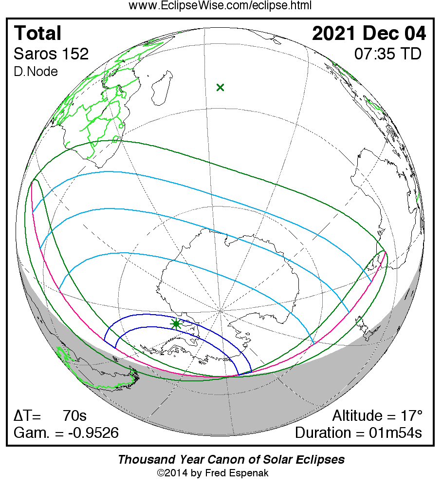
The path continues south across the Weddell Sea where the instant of greatest eclipse occurs at 07:33:27 UT1. The duration is 1 minute 54 seconds, the sun’s altitude is 17°, and the path width is 260 miles (419 km).
Traversing the Ronne Ice Shelf, the path quickly crosses Antarctica and reaches the coast of the Amundsen Sea at 08:01 UT1. The central duration has dropped to 1 minute 38 seconds and the sun is 7° above the horizon. Now heading north, the umbral path ends three minutes later as the shadow lifts off of Earth in the Southern Ocean at 08:04 UT1.
Find maps and eclipse timings below. Remember to convert UTC to your time. You can visit TimeandDate.com to get an exact timing of the eclipse from your location. The number one rule for solar eclipse observing is to make sure you protect your eyes by using an appropriate filter.
Eclipse times
The instant of greatest eclipse takes place on December 4, 2021, at 07:33:28 UT1. Greatest eclipse takes place 0.1 days before the moon reaches perigee, its closest point to Earth for the month. So it’s a relatively large-sized moon that covers the sun during this eclipse. During the eclipse, the sun is in the constellation Ophiuchus.
Saros and eclipse season
The eclipse belongs to Saros 152 and is number 13 of 70 eclipses in the series. All eclipses in this series occur at the moon’s descending node. The moon moves northward with respect to the node with each succeeding eclipse in the series.
The total solar eclipse of December 4, 2021, is preceded two weeks earlier by a partial lunar eclipse on November 19, 2021.
These eclipses all take place during a single eclipse season.
Maps and data for the total solar eclipse
Orthographic Map: total solar eclipse of December 4, 2021, detailed map of eclipse visibility
Animated Map: total solar eclipse of December 4, 2021, animated map of the moon’s shadows across Earth
Google Map: total solar eclipse of December 4, 2021, interactive map of the eclipse path
Path Table: total solar eclipse of December 4, 2021, coordinates of the central line and path limits
Circumstances Table: December 4, 2021 total solar eclipse, eclipse times for hundreds of cities
Saros 152 Table: data for all eclipses in the Saros series
Additional Tables and Data for this event

Bottom line: A total solar eclipse will occur on Saturday, December 4, 2021. The path of totality sweeps across Antarctica. But people in southernmost South America, Africa, Australia and New Zealand have a shot at the partial phases.
The post Total solar eclipse of December 4, 2021 first appeared on EarthSky.
from EarthSky https://ift.tt/3zEmZFx
Total solar eclipse
A total solar eclipse sweeps across Antarctica on December 4, 2021. People located at the southernmost tips of South America, Africa, Australia and New Zealand will experience the partial phases. The path of the moon’s umbral shadow begins in the Southern Ocean about 300 miles (500 km) southeast of the Falkland Islands, crosses the Antarctic continent, and ends at sunset in the Southern Ocean. A partial eclipse will be seen within the much broader path of the moon’s penumbral shadow, which includes the Southern Ocean, southern Africa and the southeastern corner of Australia and Tasmania.
The eastern edge of the eclipse path passes within 225 miles (360 km) of South Georgia. Renowned as for its whaling stations during the first half of the 20th century, and as the starting and ending point of Sir Ernest Shackleton’s remarkable attempt to cross the Antarctic continent (1914-1917).
The South Orkney Islands are the only land in the path prior to reaching Antarctica. However, they straddle the western edge of the path with appropriately named Coronation Islands bisected by the path edge. Apart from the personnel at several research stations, there are no permanent inhabitants on the islands. From the eastern coast of easternmost Laurie Island, the duration of totality is 1 minute 8 seconds with the sun 8° above the horizon.
The path continues south across the Weddell Sea where the instant of greatest eclipse occurs at 07:33:27 UT1. The duration is 1 minute 54 seconds, the sun’s altitude is 17°, and the path width is 260 miles (419 km).
Traversing the Ronne Ice Shelf, the path quickly crosses Antarctica and reaches the coast of the Amundsen Sea at 08:01 UT1. The central duration has dropped to 1 minute 38 seconds and the sun is 7° above the horizon. Now heading north, the umbral path ends three minutes later as the shadow lifts off of Earth in the Southern Ocean at 08:04 UT1.
Find maps and eclipse timings below. Remember to convert UTC to your time. You can visit TimeandDate.com to get an exact timing of the eclipse from your location. The number one rule for solar eclipse observing is to make sure you protect your eyes by using an appropriate filter.
Eclipse times
The instant of greatest eclipse takes place on December 4, 2021, at 07:33:28 UT1. Greatest eclipse takes place 0.1 days before the moon reaches perigee, its closest point to Earth for the month. So it’s a relatively large-sized moon that covers the sun during this eclipse. During the eclipse, the sun is in the constellation Ophiuchus.
Saros and eclipse season
The eclipse belongs to Saros 152 and is number 13 of 70 eclipses in the series. All eclipses in this series occur at the moon’s descending node. The moon moves northward with respect to the node with each succeeding eclipse in the series.
The total solar eclipse of December 4, 2021, is preceded two weeks earlier by a partial lunar eclipse on November 19, 2021.
These eclipses all take place during a single eclipse season.
Maps and data for the total solar eclipse
Orthographic Map: total solar eclipse of December 4, 2021, detailed map of eclipse visibility
Animated Map: total solar eclipse of December 4, 2021, animated map of the moon’s shadows across Earth
Google Map: total solar eclipse of December 4, 2021, interactive map of the eclipse path
Path Table: total solar eclipse of December 4, 2021, coordinates of the central line and path limits
Circumstances Table: December 4, 2021 total solar eclipse, eclipse times for hundreds of cities
Saros 152 Table: data for all eclipses in the Saros series
Additional Tables and Data for this event
Bottom line: A total solar eclipse will occur on Saturday, December 4, 2021. The path of totality sweeps across Antarctica. But people in southernmost South America, Africa, Australia and New Zealand have a shot at the partial phases.
The post Total solar eclipse of December 4, 2021 first appeared on EarthSky.
from EarthSky https://ift.tt/3zEmZFx
Aucun commentaire:
Enregistrer un commentaire