
Most of Earth’s volcanoes and earthquakes are found in regions that skirt the Pacific Ocean, known as the Ring of Fire. It’s not really a ring, though, but more of a horseshoe-shaped swath – 24,900 miles (40,000 km) long – dotted with seismically active locations.
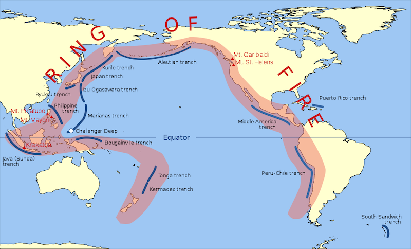
If you could view it from space, the Ring of Fire would appear as a strip that runs up the western coasts of South America and North America, continuing across the Alaskan Aleutian Islands to Russia’s Kamchatka Peninsula. Then, it heads south, off the coast of Eastern Asia, passing through Japan. At Southeast Asia, it jogs eastward through the Indonesian islands of Sumatra and Java, past Papua New Guinea, then southward again to New Zealand.
Volcanoes
Geologists have found evidence of prehistoric volcanoes, almost 1,000 of them, along the Ring of Fire that were active in the past 12,000 years. During this period, the four largest volcanic eruptions on our planet occurred in Alaska, Japan, Russia, and the US.
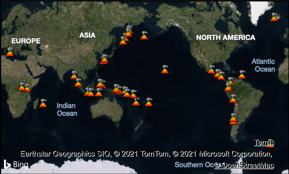
The iconic Mt. Fuji of Japan is in one of several volcanic chains that make up the Ring of Fire. It has been relatively quiet in recent years, with just minor eruptions.
In contrast, Mount St. Helen’s eruption in 1980 shocked the world. It was the most significant volcanic eruption in US history, causing a catastrophic explosion that resulted in the largest known landslide recorded and an ash plume that reached 80,000 feet. The explosion obliterated the surrounding 230 square miles in minutes.
Meanwhile, along the Ring of Fire, there’s always something happening, volcanically speaking … The Pacaya Volcano in Guatemala made the news in April 2021 following a series of eruptions that created wildfires and destroyed nearby plantations.
In April 2020, a volcano named Anak Krakatau caused a lot of excitement on social media and the news with dramatic new eruptions. It emerged from the caldera of the infamously violent Krakatoa volcanic explosion of 1883
New land also continues to be created in the Ring of Fire. A young volcano is making itself known off the coast of Japan. The Nishinoshima volcano has been growing since 2013, and underwent a growth spurt in June 2020.
Earthquakes
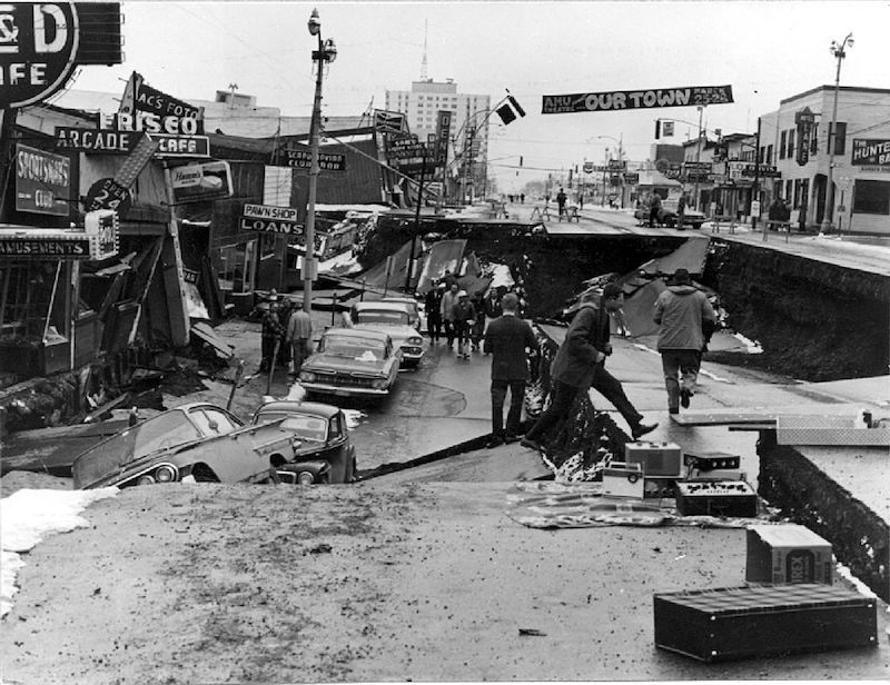
About 90% of all earthquakes, and 80% of the largest ones, occur in the Ring of Fire. Since the invention of equipment to measure earthquake intensity in the 1930s, four of the most powerful earthquakes have occurred in the Ring of Fire. In 1952, a magnitude 9.0 earthquake struck the Kamchatka Peninsula of Russia. Chile’s Valdivia earthquake in 1960 was a stunning 9.4 to 9.6 on the Richter scale. Four years later, a magnitude 9.2 earthquake hit Alaska.
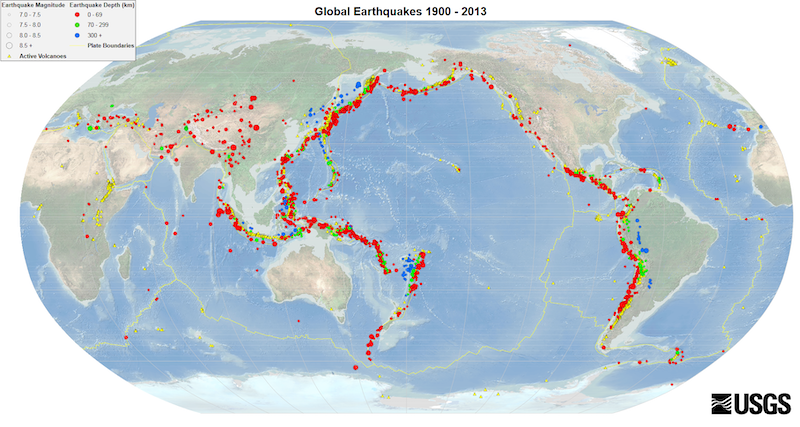
And, more recently, the 2011 Tohoku Earthquake in Japan has become seared in our memories. The world watched, horrified, as large stretches of coastal land, including communities, near Sendai, Japan were engulfed in a tsunami that was triggered by an offshore earthquake. It caused widespread death, destruction, and lead to the serious breach of a nuclear reactor.
Why is the Ring of Fire so seismically active?
Volcanoes and earthquakes most often occur along the borders of tectonic plates. These plates are layers of the Earth’s crust that float — moving very slowly — on molten rock in Earth’s mantle.
The Ring of Fire is not a single geological feature, but actually separate adjoining features caused by interactions of several different tectonic plates. Where the two plates meet, in what’s called a subduction zone, the heavier plate sinks below the lighter plate and melts in the Earth’s molten mantle.
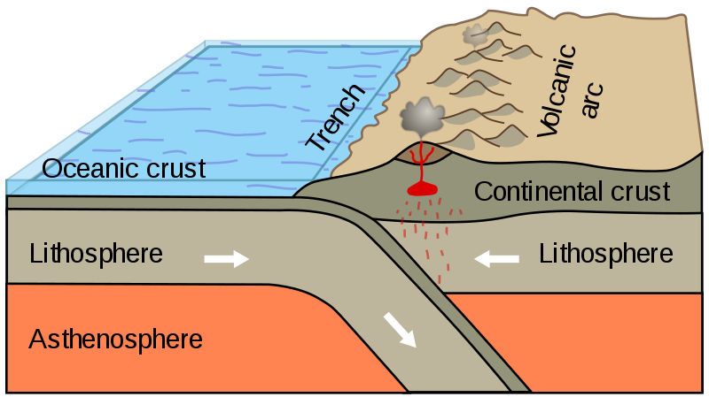
Image via Booyabazooka / Wikimedia Commons.
There are several plates causing seismic activity along the Ring of Fire. In most locations, the plates are colliding, causing subduction zones. (An exception: in a section of western North America, the plates are rubbing against each other laterally. This builds up tension that is occasionally released as earthquakes.)
Some of these subduction zones are also the deepest parts of the ocean. The Marianas Trench, 36,037 feet (10,984 m) — that’s 6.8 miles (11 km) — below sea level at its deepest known point, is in a subduction zone.
When tension from a bending plate is released, earthquakes happen. At some locations, molten rock is able to infiltrate through the crust to create volcanoes. Most of these seismic activities happen undersea.
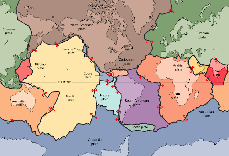
Image via USGS / Wikimedia Commons.
Bottom line: The Ring of Fire is a region of active seismic activity caused by interacting tectonic plates. It includes most of Earth’s volcanoes and earthquakes.
The post What is Earth’s Ring of Fire? first appeared on EarthSky.
from EarthSky https://ift.tt/2T3kGMN
Most of Earth’s volcanoes and earthquakes are found in regions that skirt the Pacific Ocean, known as the Ring of Fire. It’s not really a ring, though, but more of a horseshoe-shaped swath – 24,900 miles (40,000 km) long – dotted with seismically active locations.
If you could view it from space, the Ring of Fire would appear as a strip that runs up the western coasts of South America and North America, continuing across the Alaskan Aleutian Islands to Russia’s Kamchatka Peninsula. Then, it heads south, off the coast of Eastern Asia, passing through Japan. At Southeast Asia, it jogs eastward through the Indonesian islands of Sumatra and Java, past Papua New Guinea, then southward again to New Zealand.
Volcanoes
Geologists have found evidence of prehistoric volcanoes, almost 1,000 of them, along the Ring of Fire that were active in the past 12,000 years. During this period, the four largest volcanic eruptions on our planet occurred in Alaska, Japan, Russia, and the US.
The iconic Mt. Fuji of Japan is in one of several volcanic chains that make up the Ring of Fire. It has been relatively quiet in recent years, with just minor eruptions.
In contrast, Mount St. Helen’s eruption in 1980 shocked the world. It was the most significant volcanic eruption in US history, causing a catastrophic explosion that resulted in the largest known landslide recorded and an ash plume that reached 80,000 feet. The explosion obliterated the surrounding 230 square miles in minutes.
Meanwhile, along the Ring of Fire, there’s always something happening, volcanically speaking … The Pacaya Volcano in Guatemala made the news in April 2021 following a series of eruptions that created wildfires and destroyed nearby plantations.
In April 2020, a volcano named Anak Krakatau caused a lot of excitement on social media and the news with dramatic new eruptions. It emerged from the caldera of the infamously violent Krakatoa volcanic explosion of 1883
New land also continues to be created in the Ring of Fire. A young volcano is making itself known off the coast of Japan. The Nishinoshima volcano has been growing since 2013, and underwent a growth spurt in June 2020.
Earthquakes
About 90% of all earthquakes, and 80% of the largest ones, occur in the Ring of Fire. Since the invention of equipment to measure earthquake intensity in the 1930s, four of the most powerful earthquakes have occurred in the Ring of Fire. In 1952, a magnitude 9.0 earthquake struck the Kamchatka Peninsula of Russia. Chile’s Valdivia earthquake in 1960 was a stunning 9.4 to 9.6 on the Richter scale. Four years later, a magnitude 9.2 earthquake hit Alaska.
And, more recently, the 2011 Tohoku Earthquake in Japan has become seared in our memories. The world watched, horrified, as large stretches of coastal land, including communities, near Sendai, Japan were engulfed in a tsunami that was triggered by an offshore earthquake. It caused widespread death, destruction, and lead to the serious breach of a nuclear reactor.
Why is the Ring of Fire so seismically active?
Volcanoes and earthquakes most often occur along the borders of tectonic plates. These plates are layers of the Earth’s crust that float — moving very slowly — on molten rock in Earth’s mantle.
The Ring of Fire is not a single geological feature, but actually separate adjoining features caused by interactions of several different tectonic plates. Where the two plates meet, in what’s called a subduction zone, the heavier plate sinks below the lighter plate and melts in the Earth’s molten mantle.
Image via Booyabazooka / Wikimedia Commons.
There are several plates causing seismic activity along the Ring of Fire. In most locations, the plates are colliding, causing subduction zones. (An exception: in a section of western North America, the plates are rubbing against each other laterally. This builds up tension that is occasionally released as earthquakes.)
Some of these subduction zones are also the deepest parts of the ocean. The Marianas Trench, 36,037 feet (10,984 m) — that’s 6.8 miles (11 km) — below sea level at its deepest known point, is in a subduction zone.
When tension from a bending plate is released, earthquakes happen. At some locations, molten rock is able to infiltrate through the crust to create volcanoes. Most of these seismic activities happen undersea.
Image via USGS / Wikimedia Commons.
Bottom line: The Ring of Fire is a region of active seismic activity caused by interacting tectonic plates. It includes most of Earth’s volcanoes and earthquakes.
The post What is Earth’s Ring of Fire? first appeared on EarthSky.
from EarthSky https://ift.tt/2T3kGMN
Aucun commentaire:
Enregistrer un commentaire