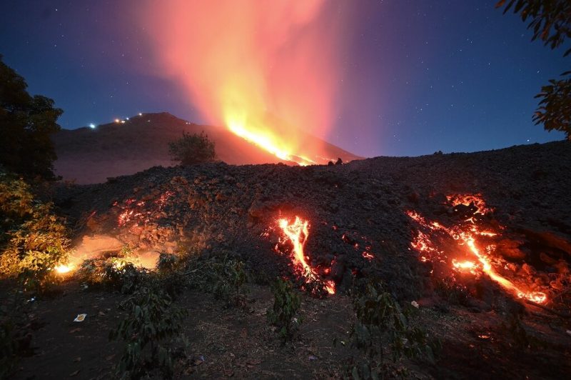

Falling ash from the Pacaya volcano forced the closure of Guatemala’s only international airport on March 23 for almost 24 hours. Image via Phys.org.
Guatemala’s Pacaya volcano is maintaining high levels of activity, with strong eruptions spewing rivers of lava and ash clouds, officials said today (April 7, 2021). The national disaster coordination body said that the advancing lava has caused wildfires and the destruction of coffee and avocado plantations.
The 8,200-foot (2,500-meter) Pacaya volcano, one of the most active of the country’s 38 volcanoes, lies about 15 miles (25 km) south of the capital city of Guatemala City. After being dormant for over 70 years, Pacaya began erupting vigorously in 1961 and has been erupting frequently since then. It has been steadily active in 2021, with two strong explosions at the end of last month (March 24-30, 2021).
In recent weeks, Pacaya’s fiery reach has stretched closer to human settlements in Guatemala. The volcano has been displaying what scientists refer to as strombolian activity – short-lived, explosive outbursts of lava – fueling lava fountains and flows, and spewing plumes into the air. According to a NASA report, plumes of gas and ash have risen as high as 13,000 feet (4,500 meters) above sea level from the volcano’s Mackenney summit crater, which stands at 8,000 feet (2500 meters). Lava has flowed 1.5 to 2 miles (2 to 3 km) down the west flank of Pacaya. Stay updated on Pacaya here.
#Erupción del #volcán #Pacaya en curso. #Guatemala ?? Abril 2 de 2021
Se registran explosiones, ceniza en dirección Sur, flujo de lava mantiene 4 ramificaciones de 800m aprox. de largo destruyendo cultivos y vegetación
Fuente @ConredGuatemala
Video ? @Spainiranpress pic.twitter.com/GhQ7ko3cK4— Geól. Sergio Almazán (@chematierra) April 3, 2021

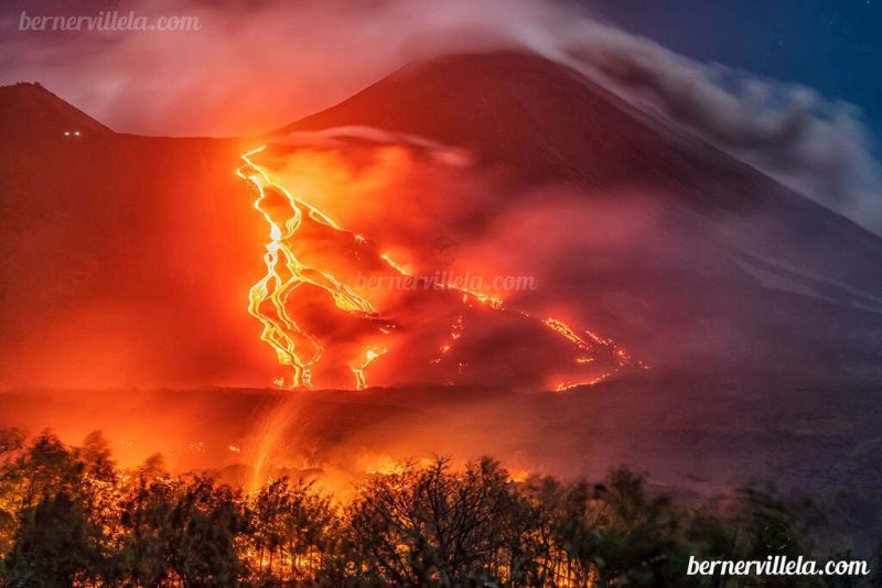
View larger. | Lava flows from Pacaya inundating bush land on March 29. Image via Berner Villela Fotografía / Volcano Discovery.

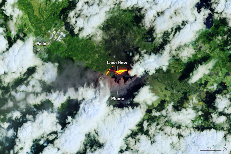
On March 29, 2021, NASA’s Landsat 8 satellite acquired this image of the eruption. The image combines shortwave infrared and red light (OLI bands 7-6-4) to better distinguish the heat signature of volcanic lava amid the vegetation and clouds. Image via NASA Earth Observatory.
?#MonitoreoVolcánico ??? | Imágenes actualizadas del volcán de #Pacaya de el satélite Sentinel-2 en formato de SWIR y FALSE COLOR URBAN (300 mts, 500mts, 1km y 3km de zoom), de @CopernicusEU. Correspondientes al día: (04/04/2021). #SomosSIMEVU #RFN #TrabajmosPorLaPrevención. pic.twitter.com/2SFbue5WEk
— Sismología Nacional de Guatemala (@Simevungt_ofi) April 6, 2021

Lava flowing out of the Pacaya volcano, 15 miles (25 km) south of Guatemala City on March 25, 2021. Image via Phys.org.
Bottom line: As of early April 2021, the Pacaya volcano in Guatemala is still erupting, spewing rivers of lava and ash clouds. See photos, video, and satellite images.
from EarthSky https://ift.tt/3wuRWvA


Falling ash from the Pacaya volcano forced the closure of Guatemala’s only international airport on March 23 for almost 24 hours. Image via Phys.org.
Guatemala’s Pacaya volcano is maintaining high levels of activity, with strong eruptions spewing rivers of lava and ash clouds, officials said today (April 7, 2021). The national disaster coordination body said that the advancing lava has caused wildfires and the destruction of coffee and avocado plantations.
The 8,200-foot (2,500-meter) Pacaya volcano, one of the most active of the country’s 38 volcanoes, lies about 15 miles (25 km) south of the capital city of Guatemala City. After being dormant for over 70 years, Pacaya began erupting vigorously in 1961 and has been erupting frequently since then. It has been steadily active in 2021, with two strong explosions at the end of last month (March 24-30, 2021).
In recent weeks, Pacaya’s fiery reach has stretched closer to human settlements in Guatemala. The volcano has been displaying what scientists refer to as strombolian activity – short-lived, explosive outbursts of lava – fueling lava fountains and flows, and spewing plumes into the air. According to a NASA report, plumes of gas and ash have risen as high as 13,000 feet (4,500 meters) above sea level from the volcano’s Mackenney summit crater, which stands at 8,000 feet (2500 meters). Lava has flowed 1.5 to 2 miles (2 to 3 km) down the west flank of Pacaya. Stay updated on Pacaya here.
#Erupción del #volcán #Pacaya en curso. #Guatemala ?? Abril 2 de 2021
Se registran explosiones, ceniza en dirección Sur, flujo de lava mantiene 4 ramificaciones de 800m aprox. de largo destruyendo cultivos y vegetación
Fuente @ConredGuatemala
Video ? @Spainiranpress pic.twitter.com/GhQ7ko3cK4— Geól. Sergio Almazán (@chematierra) April 3, 2021

View larger. | Lava flows from Pacaya inundating bush land on March 29. Image via Berner Villela Fotografía / Volcano Discovery.

On March 29, 2021, NASA’s Landsat 8 satellite acquired this image of the eruption. The image combines shortwave infrared and red light (OLI bands 7-6-4) to better distinguish the heat signature of volcanic lava amid the vegetation and clouds. Image via NASA Earth Observatory.
?#MonitoreoVolcánico ??? | Imágenes actualizadas del volcán de #Pacaya de el satélite Sentinel-2 en formato de SWIR y FALSE COLOR URBAN (300 mts, 500mts, 1km y 3km de zoom), de @CopernicusEU. Correspondientes al día: (04/04/2021). #SomosSIMEVU #RFN #TrabajmosPorLaPrevención. pic.twitter.com/2SFbue5WEk
— Sismología Nacional de Guatemala (@Simevungt_ofi) April 6, 2021

Lava flowing out of the Pacaya volcano, 15 miles (25 km) south of Guatemala City on March 25, 2021. Image via Phys.org.
Bottom line: As of early April 2021, the Pacaya volcano in Guatemala is still erupting, spewing rivers of lava and ash clouds. See photos, video, and satellite images.
from EarthSky https://ift.tt/3wuRWvA

Aucun commentaire:
Enregistrer un commentaire