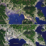
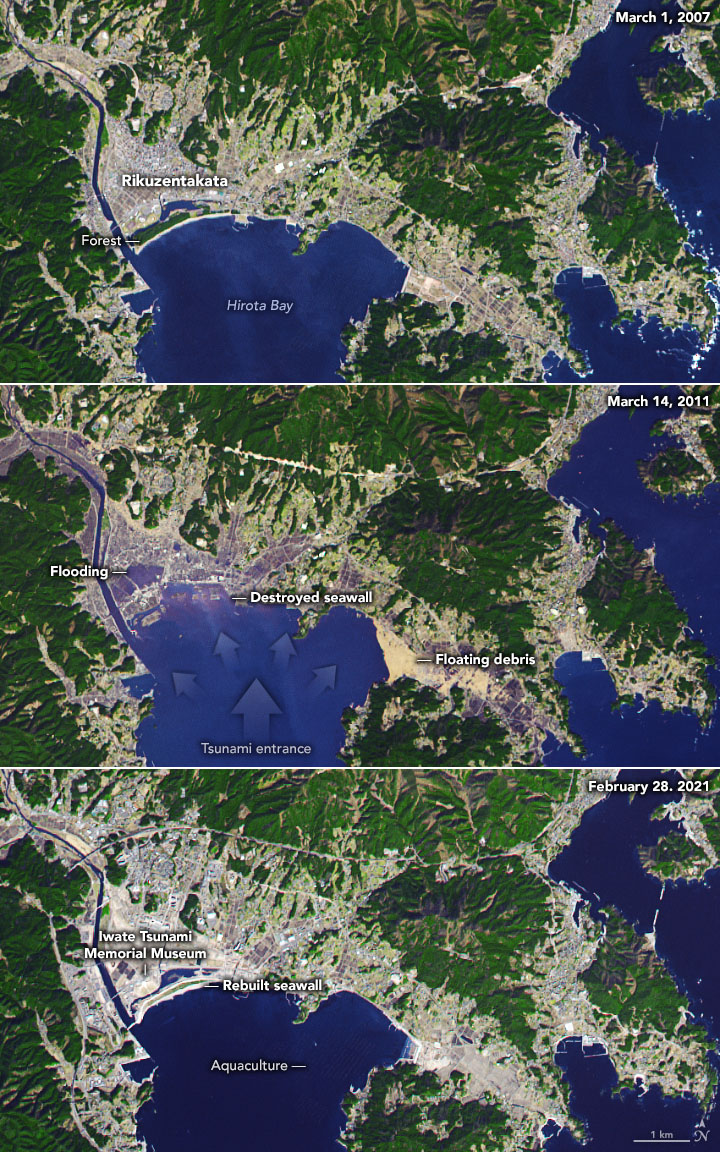
Some of the worst devastation from the March 11, 2011 9.1-magnitude earthquake, and subsequent tsunami, took place in the city of Rikuzentakata, Japan. The images above were acquired in 2007, 2011, and 2021 by the Advanced Spaceborne Thermal Emission and Reflection Radiometer (ASTER), a joint Japanese and U.S. instrument on NASA’s Terra satellite. Image via NASA Earth Observatory.
More than 10 years after the 9.1-magnitude earthquake that rocked Japan on March 11, 2011 – triggering a devastating tsunami that destroyed much human infrastructure and left 20,000 dead – at least one coastal city in Japan is still recovering. Rikuzentakata, a harbor city that borders Hirota Bay, is located in Iwate Prefecture in northeastern Japan. In parts of Iwate Prefecture, the tsunami reached a run-up height – or maximum inundation point above sea level – of 133 feet (40.5 meters).
Approximately 8 percent of the population of Rikuzentakata was lost to the colossal waves, and 80 percent of the residential areas were destroyed.
The tsunami swept away a pine forest that was meant to act as tidewater control between the bay and the city. Some 70,000 trees were lost to the sea. Farm land was swamped with seawater for weeks.
Rikuzentakata is located northward of the now-disabled Fukushima Daiichi Nuclear Power Plant, which also underwent a major disaster due to the events of March 11, 2011.
Before. In this image taken March 1, 2007, some years before the tsunami, you can see the intact seawall and forest around the bay, defending the city of Rikuzentakata, Japan. Image via NASA.
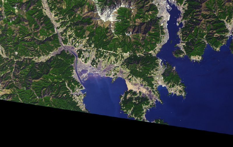
After. Just three days after the destructive tsunami, NASA captured this photo of one of the hardest-hit areas on March 14, 2011. The city of Rikuzentakata is flooded with water where the seawall was destroyed, to the upper left of the bay. A large swath of debris floats in the bay on the right side. Image via NASA.
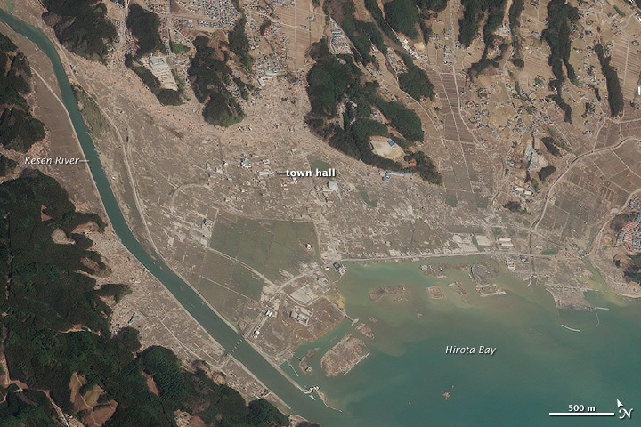
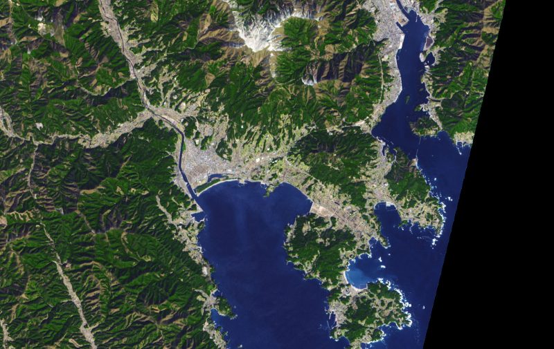
In this closeup view of Rikuzentakata captured by NASA on March 14, 2011, you can see more clearly the extent to which the waves bulldozed the land flat and washed everything out to sea, leaving the earth scoured. Image via NASA.
A 41-foot-high (12.5-meter) seawall now replaces the one wiped away by the tsunami. In the 2021 image at top, you can see the extensive forest along the seawall has not yet recovered. In the midst of the devastated area that was flooded in the wake of the tsunami, a museum now stands as a testament to the power of nature and the indefatigable spirit of the Japanese people. The mission statement of the Iwate Tsunami Memorial Museum reads:
The Japanese Archipelago is one of the places on Earth most threatened by natural disaster, and we who spent many years living on this land have built up a strong will to oppose this danger. Despite this, in the wake of the March 2011 Great East Japan Earthquake and Tsunami, we suffered an immense loss of life. In order to avoid repeating this sorrow, it is of utmost importance that we possess the knowledge, wisdom, and motivation to protect ourselves against various natural disasters, and thus become able to overcome them. The Iwate Tsunami Memorial Museum will share the wisdom of our predecessors, the reality of the Great East Japan Earthquake and Tsunami and the lessons we’ve learned with the world to become a society strong against natural disaster. In addition, as part of our efforts in overcoming the Great East Japan Earthquake and Tsunami, we’d like to show our gratitude for the support we have received.
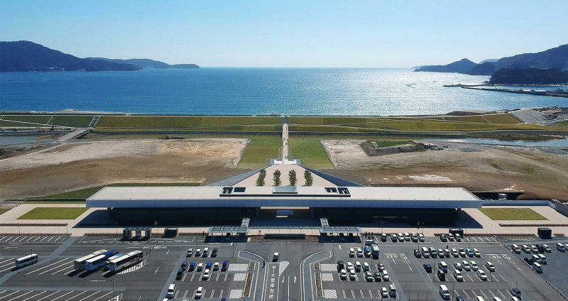
The Iwate Tsunami Memorial Museum sits facing Hirota Bay, where the tsunami came onshore in 2011. Image via Iwate Tsunami Memorial Museum.
Bottom line: Ten years after the 9.1-magnitude earthquake and deadly tsunami that inundated the coastline of northeastern Japan, satellite images show how far the city of Rikuzentakata has come.
from EarthSky https://ift.tt/3f1cq96
Some of the worst devastation from the March 11, 2011 9.1-magnitude earthquake, and subsequent tsunami, took place in the city of Rikuzentakata, Japan. The images above were acquired in 2007, 2011, and 2021 by the Advanced Spaceborne Thermal Emission and Reflection Radiometer (ASTER), a joint Japanese and U.S. instrument on NASA’s Terra satellite. Image via NASA Earth Observatory.
More than 10 years after the 9.1-magnitude earthquake that rocked Japan on March 11, 2011 – triggering a devastating tsunami that destroyed much human infrastructure and left 20,000 dead – at least one coastal city in Japan is still recovering. Rikuzentakata, a harbor city that borders Hirota Bay, is located in Iwate Prefecture in northeastern Japan. In parts of Iwate Prefecture, the tsunami reached a run-up height – or maximum inundation point above sea level – of 133 feet (40.5 meters).
Approximately 8 percent of the population of Rikuzentakata was lost to the colossal waves, and 80 percent of the residential areas were destroyed.
The tsunami swept away a pine forest that was meant to act as tidewater control between the bay and the city. Some 70,000 trees were lost to the sea. Farm land was swamped with seawater for weeks.
Rikuzentakata is located northward of the now-disabled Fukushima Daiichi Nuclear Power Plant, which also underwent a major disaster due to the events of March 11, 2011.
Before. In this image taken March 1, 2007, some years before the tsunami, you can see the intact seawall and forest around the bay, defending the city of Rikuzentakata, Japan. Image via NASA.
After. Just three days after the destructive tsunami, NASA captured this photo of one of the hardest-hit areas on March 14, 2011. The city of Rikuzentakata is flooded with water where the seawall was destroyed, to the upper left of the bay. A large swath of debris floats in the bay on the right side. Image via NASA.
In this closeup view of Rikuzentakata captured by NASA on March 14, 2011, you can see more clearly the extent to which the waves bulldozed the land flat and washed everything out to sea, leaving the earth scoured. Image via NASA.
A 41-foot-high (12.5-meter) seawall now replaces the one wiped away by the tsunami. In the 2021 image at top, you can see the extensive forest along the seawall has not yet recovered. In the midst of the devastated area that was flooded in the wake of the tsunami, a museum now stands as a testament to the power of nature and the indefatigable spirit of the Japanese people. The mission statement of the Iwate Tsunami Memorial Museum reads:
The Japanese Archipelago is one of the places on Earth most threatened by natural disaster, and we who spent many years living on this land have built up a strong will to oppose this danger. Despite this, in the wake of the March 2011 Great East Japan Earthquake and Tsunami, we suffered an immense loss of life. In order to avoid repeating this sorrow, it is of utmost importance that we possess the knowledge, wisdom, and motivation to protect ourselves against various natural disasters, and thus become able to overcome them. The Iwate Tsunami Memorial Museum will share the wisdom of our predecessors, the reality of the Great East Japan Earthquake and Tsunami and the lessons we’ve learned with the world to become a society strong against natural disaster. In addition, as part of our efforts in overcoming the Great East Japan Earthquake and Tsunami, we’d like to show our gratitude for the support we have received.
The Iwate Tsunami Memorial Museum sits facing Hirota Bay, where the tsunami came onshore in 2011. Image via Iwate Tsunami Memorial Museum.
Bottom line: Ten years after the 9.1-magnitude earthquake and deadly tsunami that inundated the coastline of northeastern Japan, satellite images show how far the city of Rikuzentakata has come.
from EarthSky https://ift.tt/3f1cq96
Aucun commentaire:
Enregistrer un commentaire