ESA’s newest Earth from Space video, released September 11, 2020, takes us over the Amazon River as it meanders through the Amazon rainforest in South America, thanks to images captured by the Copernicus Sentinel-1 satellite mission.
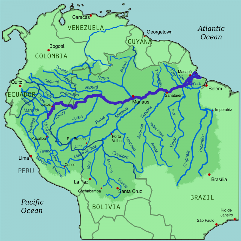
The Amazon River begins its journey in the Andes and makes its way east through six South American countries before emptying into the Atlantic Ocean on the northeast coast of Brazil. The river has a length of around 4,000 miles (6,400 km), about the distance from New York City to Rome.

View larger. | Map of the Amazon River drainage basin with the Amazon River highlighted. Image via Wikipedia.

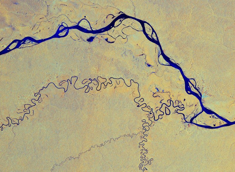
View larger. | This image has been processed in a way that shows water bodies, such as the Amazon River, in blue. The colors in the image come from the combination of 2 polarizations from the Copernicus Sentinel-1 radar mission, which have been converted into a single image. Image via ESA.
The Amazon is considered the widest river in the world, with a width of between 1-6.2 miles (1.6-10 km), which expands during the wet season to around 30 miles (50 km). As a consequence of its ever-changing flow, older riverbeds can be seen as thin lines around the main river at the top of the image, above.
The Amazon River has more than 1,000 tributaries, and the largest drainage system in the world. One of its tributaries, the Javari River, or Yavari River, is visible as a thinner blue line weaving through the tropical rainforest. The river flows for 540 miles (870 km), forming the border between Brazil and Peru, before joining the Amazon River.
In the above image, cities and built-up areas are visible in cyan (greenish blue), for example the cities of Tabatinga, Brazil and Leticia, Colombia with two airports are easily identifiable in the far-right. The yellow and orange colors in the image show the surrounding Amazon forest.
Bottom line: ESA’s newest Earth from Space video takes us over the Amazon River as it meanders through the Amazon rainforest in South America.
from EarthSky https://ift.tt/3hyxS2S

ESA’s newest Earth from Space video, released September 11, 2020, takes us over the Amazon River as it meanders through the Amazon rainforest in South America, thanks to images captured by the Copernicus Sentinel-1 satellite mission.
The Amazon River begins its journey in the Andes and makes its way east through six South American countries before emptying into the Atlantic Ocean on the northeast coast of Brazil. The river has a length of around 4,000 miles (6,400 km), about the distance from New York City to Rome.

View larger. | Map of the Amazon River drainage basin with the Amazon River highlighted. Image via Wikipedia.

View larger. | This image has been processed in a way that shows water bodies, such as the Amazon River, in blue. The colors in the image come from the combination of 2 polarizations from the Copernicus Sentinel-1 radar mission, which have been converted into a single image. Image via ESA.
The Amazon is considered the widest river in the world, with a width of between 1-6.2 miles (1.6-10 km), which expands during the wet season to around 30 miles (50 km). As a consequence of its ever-changing flow, older riverbeds can be seen as thin lines around the main river at the top of the image, above.
The Amazon River has more than 1,000 tributaries, and the largest drainage system in the world. One of its tributaries, the Javari River, or Yavari River, is visible as a thinner blue line weaving through the tropical rainforest. The river flows for 540 miles (870 km), forming the border between Brazil and Peru, before joining the Amazon River.
In the above image, cities and built-up areas are visible in cyan (greenish blue), for example the cities of Tabatinga, Brazil and Leticia, Colombia with two airports are easily identifiable in the far-right. The yellow and orange colors in the image show the surrounding Amazon forest.
Bottom line: ESA’s newest Earth from Space video takes us over the Amazon River as it meanders through the Amazon rainforest in South America.
from EarthSky https://ift.tt/3hyxS2S

Aucun commentaire:
Enregistrer un commentaire