
Welcome to the 2020 Atlantic hurricane season. Although we’ve had two named storms already, the official season starts today – June 1 – and runs until November 30.
The two named storms that formed before hurricane season’s official start are Arthur, which formed May 16 and passed just 25 miles (40 km) south of Cape Hatteras, North Carolina, and Bertha, which formed off the East Coast early this past week, and made landfall on Wednesday (May 27) east of Charleston, South Carolina, with 50 mile-per-hour (80 km-per-hour) winds.
The U.S. National Oceanic and Atmospheric Administration (NOAA) released a statement on May 21, 2020, saying its forecasters are calling for an active 2020 Atlantic hurricane season, perhaps similar to last year’s, with more named storms than in an average season.
The 2020 NOAA forecast calls for a likely range of 13 to 19 named storms (winds of 39 mph – 63 kph – or higher), of which six to 10 could become hurricanes (winds of 74 mph – 119 kph – or higher), including three to six major hurricanes (category 3, 4 or 5; with winds of 111 mph – 179 kph – or higher). The powerful 2019 Atlantic hurricane season saw 18 named storms, six of which were hurricanes, including three major hurricanes. An average hurricane season produces 12 named storms, of which six become hurricanes, including three major hurricanes.
Hurricane names for 2020, plus how hurricanes get their names
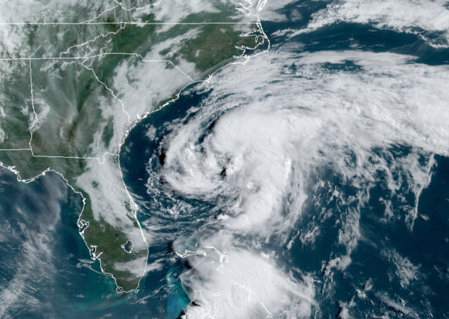
Tropical Storm Arthur swirls off the southeast coast of the U.S. on the morning of Sunday, May 17, 2020. Image via CIRA/ RAMMB/ Accuweather.
NOAA said its outlook calls for a 60% chance of an above-normal season, a 30% chance of a near-normal season and only a 10% chance of a below-normal season, and it said the agency:
… provides these ranges with a 70% confidence.
The annual Atlantic hurricane forecast comes from NOAA’s Climate Prediction Center, a division of the U.S. National Weather Service.
Find NOAA’s full 2020 Atlantic Hurricane Season Outlook here
In addition to the Atlantic hurricane season outlook, NOAA also issued seasonal hurricane outlooks for the eastern Pacific and central Pacific basins.
NOAA’s 2020 Atlantic hurricane outlook comes on the heels of a new study from scientists at the University of Wisconsin suggesting that global warming is making hurricanes stronger. The study was based on analysis of nearly 40 years of satellite imagery of hurricanes. Their results say that – over the past four decades – hurricanes have become more intense and destructive.
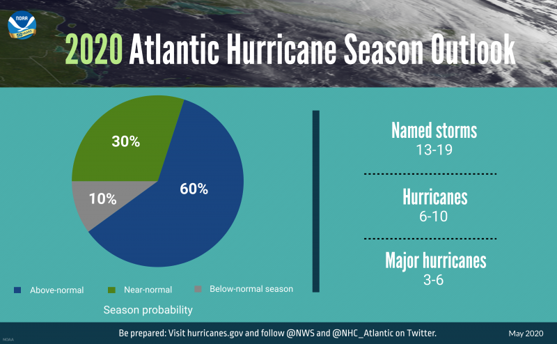
Hurricane season probabilities and numbers of named storms predicted via NOAA’s 2020 Atlantic Hurricane Season Outlook. Image via NOAA.
NOAA linked its forecast of an active 2020 hurricane season to Earth’s current climate, saying:
El Nino Southern Oscillation (ENSO) conditions are expected to either remain neutral or to trend toward La Nina, meaning there will not be an El Nino present to suppress hurricane activity. Also, warmer-than-average sea surface temperatures in the tropical Atlantic ocean and Caribbean sea, coupled with reduced vertical wind shear, weaker tropical Atlantic trade winds, and an enhanced west African monsoon all increase the likelihood for an above-normal Atlantic hurricane season.
Similar conditions have been producing more active seasons since the current high-activity era began in 1995.

Hurricane Dorian on September 1, 2019. It was the most destructive storm of 2019, a monster hurricane that battered the Bahamas last September. It was the 4th named storm, 2nd hurricane and 1st Category 5 hurricane of the 2019 Atlantic hurricane season. It’s also the 4th-strongest Atlantic hurricane (as measured by 1-minute sustained wind speeds) since reliable record-keeping began in 1851. Image via National Weather Service.
According to Samantha Montano, an emergency-management expert at Massachusetts Maritime Academy, one concern for officials regarding 2020’s Atlantic hurricane season is the effect that the coronavirus will have on the volunteer responders. Many volunteers won’t be able to fly to disaster zones, she said, and those who are able to go will have a harder time interacting with people. Montano told the New York Times:
Volunteers do everything, handing out donations, moving debris off the roads, gutting houses, helping survivors navigate state and federal aid programs.

The flight deck of NOAA Lockheed WP-3D Orion N42RF during a flight into Hurricane Harvey in August 2017. Harvey was a devastating Category 4 hurricane that made landfall in Texas and Louisiana, causing catastrophic flooding and many deaths. It is tied with 2005’s Hurricane Katrina as the costliest tropical cyclone on record. Image via Lt. Kevin Doremus/ NOAA.
Bottom line: Multiple climate factors indicate above-normal activity is most likely in 2020, according to NOAA’s 2020 Atlantic Hurricane Season Outlook.
Read more: Global warming is making hurricane stronger
from EarthSky https://ift.tt/2yQKulu

Welcome to the 2020 Atlantic hurricane season. Although we’ve had two named storms already, the official season starts today – June 1 – and runs until November 30.
The two named storms that formed before hurricane season’s official start are Arthur, which formed May 16 and passed just 25 miles (40 km) south of Cape Hatteras, North Carolina, and Bertha, which formed off the East Coast early this past week, and made landfall on Wednesday (May 27) east of Charleston, South Carolina, with 50 mile-per-hour (80 km-per-hour) winds.
The U.S. National Oceanic and Atmospheric Administration (NOAA) released a statement on May 21, 2020, saying its forecasters are calling for an active 2020 Atlantic hurricane season, perhaps similar to last year’s, with more named storms than in an average season.
The 2020 NOAA forecast calls for a likely range of 13 to 19 named storms (winds of 39 mph – 63 kph – or higher), of which six to 10 could become hurricanes (winds of 74 mph – 119 kph – or higher), including three to six major hurricanes (category 3, 4 or 5; with winds of 111 mph – 179 kph – or higher). The powerful 2019 Atlantic hurricane season saw 18 named storms, six of which were hurricanes, including three major hurricanes. An average hurricane season produces 12 named storms, of which six become hurricanes, including three major hurricanes.
Hurricane names for 2020, plus how hurricanes get their names

Tropical Storm Arthur swirls off the southeast coast of the U.S. on the morning of Sunday, May 17, 2020. Image via CIRA/ RAMMB/ Accuweather.
NOAA said its outlook calls for a 60% chance of an above-normal season, a 30% chance of a near-normal season and only a 10% chance of a below-normal season, and it said the agency:
… provides these ranges with a 70% confidence.
The annual Atlantic hurricane forecast comes from NOAA’s Climate Prediction Center, a division of the U.S. National Weather Service.
Find NOAA’s full 2020 Atlantic Hurricane Season Outlook here
In addition to the Atlantic hurricane season outlook, NOAA also issued seasonal hurricane outlooks for the eastern Pacific and central Pacific basins.
NOAA’s 2020 Atlantic hurricane outlook comes on the heels of a new study from scientists at the University of Wisconsin suggesting that global warming is making hurricanes stronger. The study was based on analysis of nearly 40 years of satellite imagery of hurricanes. Their results say that – over the past four decades – hurricanes have become more intense and destructive.

Hurricane season probabilities and numbers of named storms predicted via NOAA’s 2020 Atlantic Hurricane Season Outlook. Image via NOAA.
NOAA linked its forecast of an active 2020 hurricane season to Earth’s current climate, saying:
El Nino Southern Oscillation (ENSO) conditions are expected to either remain neutral or to trend toward La Nina, meaning there will not be an El Nino present to suppress hurricane activity. Also, warmer-than-average sea surface temperatures in the tropical Atlantic ocean and Caribbean sea, coupled with reduced vertical wind shear, weaker tropical Atlantic trade winds, and an enhanced west African monsoon all increase the likelihood for an above-normal Atlantic hurricane season.
Similar conditions have been producing more active seasons since the current high-activity era began in 1995.

Hurricane Dorian on September 1, 2019. It was the most destructive storm of 2019, a monster hurricane that battered the Bahamas last September. It was the 4th named storm, 2nd hurricane and 1st Category 5 hurricane of the 2019 Atlantic hurricane season. It’s also the 4th-strongest Atlantic hurricane (as measured by 1-minute sustained wind speeds) since reliable record-keeping began in 1851. Image via National Weather Service.
According to Samantha Montano, an emergency-management expert at Massachusetts Maritime Academy, one concern for officials regarding 2020’s Atlantic hurricane season is the effect that the coronavirus will have on the volunteer responders. Many volunteers won’t be able to fly to disaster zones, she said, and those who are able to go will have a harder time interacting with people. Montano told the New York Times:
Volunteers do everything, handing out donations, moving debris off the roads, gutting houses, helping survivors navigate state and federal aid programs.

The flight deck of NOAA Lockheed WP-3D Orion N42RF during a flight into Hurricane Harvey in August 2017. Harvey was a devastating Category 4 hurricane that made landfall in Texas and Louisiana, causing catastrophic flooding and many deaths. It is tied with 2005’s Hurricane Katrina as the costliest tropical cyclone on record. Image via Lt. Kevin Doremus/ NOAA.
Bottom line: Multiple climate factors indicate above-normal activity is most likely in 2020, according to NOAA’s 2020 Atlantic Hurricane Season Outlook.
Read more: Global warming is making hurricane stronger
from EarthSky https://ift.tt/2yQKulu

Aucun commentaire:
Enregistrer un commentaire