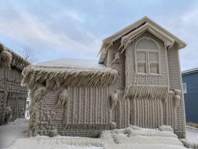

Scott Levin (@ScottLevinTV on Twitter) – a news anchor in Buffalo, New York – wrote on February 28, 2020: “Yikes! My friends frozen home in Hoover Beach Hamburg, NY!!! He’s fine… his house… is pretty ‘cool!’
A powerful storm brought blizzard conditions and lake effect snow to upstate New York late last week. What is lake effect snow? If you live on the downwind side of a large lake, you’re probably all too familiar with it. It happens when cold winter air moves over a relatively warm body of water. That’s what happened last week, when cold air moved over Lake Erie and Lake Ontario, creating a small-scale but super intense snowstorm in the western part of the state, beginning around Thursday, February 27 and extending into last weekend. According to the Washington Post’s awesome Capital Weather Gang on February 28:
Snowfall rates … approached 4 inches per hour at times.
The video below from Weather Nation on Facebook shows the storm itself and the dangerous whiteout driving conditions it created.
Here’s another one from @WeatherBug on Twitter:
Heavy lake-effect snow and high winds buried parts of upstate New York near the Great Lakes beginning on February 27,2020 and continued to rage throughout Friday.
?Lorraine, New York#WeatherBug #weather #knowbefore #wx #blizzard #NOAA #NWS pic.twitter.com/o9slP5Dxk5
— WeatherBug (@WeatherBug) February 29, 2020
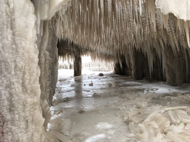
The result of the storm? Parts of upstate New York are still digging out from the snow and ice. The heaviest snowfall appears to have been concentrated in rural areas east of Lake Erie and Lake Ontario, where, in some places, some 4 feet of snow fell. What’s more, the storm left thick, fairylike ice on homes and buildings … some sources said it might take weeks to dig out from the snow.

View at EarthSky Community Photos. | Jack O’Brien captured this image on March 1, 2020 on an ice-covered patio in Hamburg, New York. Thank you, Jack!
19 Days Until Spring: Until then—-well, you know. This along Lake Erie near Buffalo (Hamburg) may take until May to melt. @news4buffalo @News_8 @spann @JimCantore @StephanieAbrams @wxbywilliams @StormHour @TomNiziol @GarofaloWX @Ginger_Zee #DigitalFirst #NexstarNation pic.twitter.com/EsvTl0ofxq
— John Kucko (@john_kucko) February 29, 2020
There are lots more amazing photos of the thick ice left in the aftermath of this winter storm – taken by Jeffrey T. Barnes of Associated Press – on this page from MellonPost in New York.
Bottom line: An intense storm and lake effect snow created a dramatic display of thick windblown ice on homes and buildings in upstate New York in late February, 2020.
from EarthSky https://ift.tt/39eSxFT


Scott Levin (@ScottLevinTV on Twitter) – a news anchor in Buffalo, New York – wrote on February 28, 2020: “Yikes! My friends frozen home in Hoover Beach Hamburg, NY!!! He’s fine… his house… is pretty ‘cool!’
A powerful storm brought blizzard conditions and lake effect snow to upstate New York late last week. What is lake effect snow? If you live on the downwind side of a large lake, you’re probably all too familiar with it. It happens when cold winter air moves over a relatively warm body of water. That’s what happened last week, when cold air moved over Lake Erie and Lake Ontario, creating a small-scale but super intense snowstorm in the western part of the state, beginning around Thursday, February 27 and extending into last weekend. According to the Washington Post’s awesome Capital Weather Gang on February 28:
Snowfall rates … approached 4 inches per hour at times.
The video below from Weather Nation on Facebook shows the storm itself and the dangerous whiteout driving conditions it created.
Here’s another one from @WeatherBug on Twitter:
Heavy lake-effect snow and high winds buried parts of upstate New York near the Great Lakes beginning on February 27,2020 and continued to rage throughout Friday.
?Lorraine, New York#WeatherBug #weather #knowbefore #wx #blizzard #NOAA #NWS pic.twitter.com/o9slP5Dxk5
— WeatherBug (@WeatherBug) February 29, 2020
The result of the storm? Parts of upstate New York are still digging out from the snow and ice. The heaviest snowfall appears to have been concentrated in rural areas east of Lake Erie and Lake Ontario, where, in some places, some 4 feet of snow fell. What’s more, the storm left thick, fairylike ice on homes and buildings … some sources said it might take weeks to dig out from the snow.

View at EarthSky Community Photos. | Jack O’Brien captured this image on March 1, 2020 on an ice-covered patio in Hamburg, New York. Thank you, Jack!
19 Days Until Spring: Until then—-well, you know. This along Lake Erie near Buffalo (Hamburg) may take until May to melt. @news4buffalo @News_8 @spann @JimCantore @StephanieAbrams @wxbywilliams @StormHour @TomNiziol @GarofaloWX @Ginger_Zee #DigitalFirst #NexstarNation pic.twitter.com/EsvTl0ofxq
— John Kucko (@john_kucko) February 29, 2020
There are lots more amazing photos of the thick ice left in the aftermath of this winter storm – taken by Jeffrey T. Barnes of Associated Press – on this page from MellonPost in New York.
Bottom line: An intense storm and lake effect snow created a dramatic display of thick windblown ice on homes and buildings in upstate New York in late February, 2020.
from EarthSky https://ift.tt/39eSxFT

Aucun commentaire:
Enregistrer un commentaire