Moonless evenings in February, March and April present the best time of year to see zodiacal light in the Northern Hemisphere evening sky. Meanwhile, from the Southern Hemisphere, the zodiacal light is best seen before dawn during these months of the year. The light appears when the evening twilight has left the sky (about 80 to 120 minutes after sunset).
It looks like a hazy pyramid of light in the west after true darkness falls.
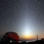
Scott Bouton didn’t wait until February, March or April to catch this great shot of the zodiacal light over Mauna Kea, Hawaii on January 15, 2018. Because Hawaii is closer to the equator, you’ll see the zodiacal light more frequently from there.
This light can be noticeable and easy to see from latitudes like those in the southern U.S. I’ve seen it many times from the latitude of southern Texas, sometimes while driving a lonely highway far from city lights, up to an hour or so after evening dusk leaves the sky.
In that case, the zodiacal light can resemble the lights of a city or town just over the horizon.
Skywatchers in the northern U.S. or Canada sometimes say wistfully that they’ve never seen the zodiacal light. On the other hand, sometimes the camera will pick up faint objects that the eye can’t see. And we’ve had reports of the zodiacal light visible to the eye by those at northerly latitudes.

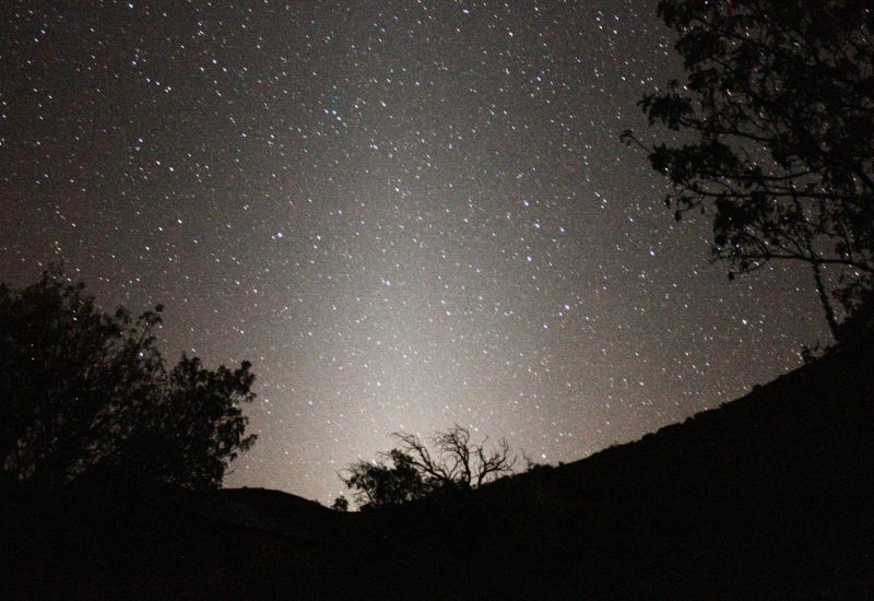
View larger. | EarthSky Facebook friend Jim Peacock is in northern Wisconsin, which is farther to the north on Earth’s globe than usual for easy viewing of the light. Yet he caught this zodiacal light in February, 2013. He said: “Yes, it was very visible to the eye … it reached high above the horizon. Was so cool to see over Lake Superior.” You can also see the Circlet of Pisces to the lower right of center – and the Y-shaped Water Jar of the constellation Aquarius to the lower right of the Circlet, just above the sunlit cloud.
You definitely do need a dark sky location to see the zodiacal light, someplace where city lights aren’t obscuring the natural lights in the sky. Remember, the zodiacal light is a pyramid-shaped glow in the west after dark. It’s even “milkier” in appearance than the starlit trail of the summer Milky Way.
The light is most visible after dusk at this time of year because (as seen from the Northern Hemisphere) the ecliptic – or path of the sun, moon, and planets – stands nearly straight up with respect to the horizon after the sun sets in February and March.
Donate: Your support means the world to us
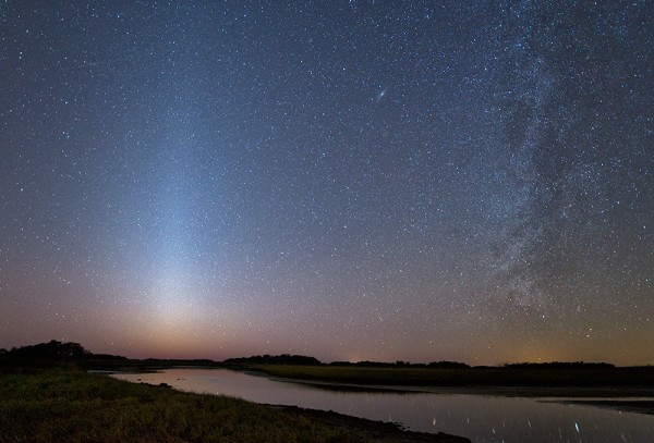
Maureen Allen in Yankeetown, Florida caught the zodiacal light (l) and Milky Way in February, 2016.
The zodiacal light can be seen for up to an hour after dusk. Unlike twilight dusk, though, there’s no rosy color to the zodiacal light. The reddish skies at dusk and dawn are caused by Earth’s atmosphere, and the zodiacal light originates far outside our atmosphere.
When you see the zodiacal light, you are looking edgewise into the plane of our own solar system. The zodiacal light is sunlight reflecting off dust particles that move in the same plane as Earth and the other planets orbiting our sun.
Remember, if you live in the Southern Hemisphere, your late winter/early spring months (August, September, October) are the best time for you to see the zodiacal light in the evening. Right now (February, March, April), you should be looking for the zodiacal light before dawn.
Bottom line: From the Northern Hemisphere, look for the elusive zodiacal light, a hazy pyramid of light extending up from the sunset point. Southern Hemisphere? Look before dawn!
Live by the moon with your 2017 EarthSky lunar calendar!
from EarthSky http://ift.tt/1Dl4MtJ
Moonless evenings in February, March and April present the best time of year to see zodiacal light in the Northern Hemisphere evening sky. Meanwhile, from the Southern Hemisphere, the zodiacal light is best seen before dawn during these months of the year. The light appears when the evening twilight has left the sky (about 80 to 120 minutes after sunset).
It looks like a hazy pyramid of light in the west after true darkness falls.
Scott Bouton didn’t wait until February, March or April to catch this great shot of the zodiacal light over Mauna Kea, Hawaii on January 15, 2018. Because Hawaii is closer to the equator, you’ll see the zodiacal light more frequently from there.
This light can be noticeable and easy to see from latitudes like those in the southern U.S. I’ve seen it many times from the latitude of southern Texas, sometimes while driving a lonely highway far from city lights, up to an hour or so after evening dusk leaves the sky.
In that case, the zodiacal light can resemble the lights of a city or town just over the horizon.
Skywatchers in the northern U.S. or Canada sometimes say wistfully that they’ve never seen the zodiacal light. On the other hand, sometimes the camera will pick up faint objects that the eye can’t see. And we’ve had reports of the zodiacal light visible to the eye by those at northerly latitudes.
View larger. | EarthSky Facebook friend Jim Peacock is in northern Wisconsin, which is farther to the north on Earth’s globe than usual for easy viewing of the light. Yet he caught this zodiacal light in February, 2013. He said: “Yes, it was very visible to the eye … it reached high above the horizon. Was so cool to see over Lake Superior.” You can also see the Circlet of Pisces to the lower right of center – and the Y-shaped Water Jar of the constellation Aquarius to the lower right of the Circlet, just above the sunlit cloud.
You definitely do need a dark sky location to see the zodiacal light, someplace where city lights aren’t obscuring the natural lights in the sky. Remember, the zodiacal light is a pyramid-shaped glow in the west after dark. It’s even “milkier” in appearance than the starlit trail of the summer Milky Way.
The light is most visible after dusk at this time of year because (as seen from the Northern Hemisphere) the ecliptic – or path of the sun, moon, and planets – stands nearly straight up with respect to the horizon after the sun sets in February and March.
Donate: Your support means the world to us
Maureen Allen in Yankeetown, Florida caught the zodiacal light (l) and Milky Way in February, 2016.
The zodiacal light can be seen for up to an hour after dusk. Unlike twilight dusk, though, there’s no rosy color to the zodiacal light. The reddish skies at dusk and dawn are caused by Earth’s atmosphere, and the zodiacal light originates far outside our atmosphere.
When you see the zodiacal light, you are looking edgewise into the plane of our own solar system. The zodiacal light is sunlight reflecting off dust particles that move in the same plane as Earth and the other planets orbiting our sun.
Remember, if you live in the Southern Hemisphere, your late winter/early spring months (August, September, October) are the best time for you to see the zodiacal light in the evening. Right now (February, March, April), you should be looking for the zodiacal light before dawn.
Bottom line: From the Northern Hemisphere, look for the elusive zodiacal light, a hazy pyramid of light extending up from the sunset point. Southern Hemisphere? Look before dawn!
Live by the moon with your 2017 EarthSky lunar calendar!
from EarthSky http://ift.tt/1Dl4MtJ