How deep is the ocean?

By Suzanne O’Connell, Wesleyan University

Explorers started making navigation charts showing how wide the ocean was more than 500 years ago. But it’s much harder to calculate how deep it is.

If you wanted to measure the depth of a pool or lake, you could tie a weight to a string, lower it to the bottom, then pull it up and measure the wet part of the string. In the ocean you would need a rope thousands of feet long.

In 1872 the HMS Challenger, a British Navy ship, set sail to learn about the ocean, including its depth. It carried 181 miles (291 km) of rope.

The remotely operated vehicle Deep Discoverer captures images of a newly discovered hydrothermal vent field in the western Pacific. Image via NOAA.

During their four-year voyage, the Challenger crew collected samples of rocks, mud and animals from many different areas of the ocean. They also found one of the deepest zones, in the western Pacific, the Mariana Trench which stretches for 1,580 miles (2,540 km).

Today scientists know that on average the ocean is 2.3 miles (3.7 km) deep, but many parts are much shallower or deeper. To measure depth they use sonar, which stands for Sound Navigation And Ranging. A ship sends out pulses of sound energy and measures depth based on how quickly the sound travels back.

Survey ships use multibeam sonar to measure the depth of the sea floor.

The deepest parts of the ocean are trenches – long, narrow depressions, like a trench in the ground, but much bigger. The HMS Challenger sampled one of these zones at the southern end of the Mariana Trench, which might be the deepest point in the ocean. Known as the Challenger Deep, it is 35,768 to 36,037 feet deep – almost 7 miles (11 km).

Ocean scientists like me study the sea floor because it helps us understand how Earth functions. For example, our planet’s outer layer is made of tectonic plates – huge moving slabs of rock and sediment. The Hawaiian-Emperor Seamount chain, a line of peaks on the ocean floor, was created when a tectonic plate moved over a spot where hot rock welled up from deep inside the Earth.

The Emperor Seamounts are a trail of underwater mountains in the Pacific, created when a tectonic plate moved across the Hawaii hotspot over millions of years. Image via NOAA

When two tectonic plates move away from each other underwater, new material rises up into Earth’s crust. This process, which creates new ocean floor, is called seafloor spreading. Sometimes super-hot fluids from inside the Earth shoot up through cracks in the ocean floor called hydrothermal vents.

Spreading at a mid-ocean ridge. Image via NASA.

Amazing fish, shellfish, tube worms and other life forms live in these zones. Between the creation and destruction of ocean plates, sediments collect on the sea floor and provide an archive of Earth’s history, the evolution of climate and life that is available nowhere else.

Suzanne O’Connell, Professor of Earth & Environmental Sciences, Wesleyan University

Bottom line: How deep is the ocean, on average and at its deepest?

This article is republished from The Conversation under a Creative Commons license. Read the original article.

The Conversation


from EarthSky https://ift.tt/2MxLZI4

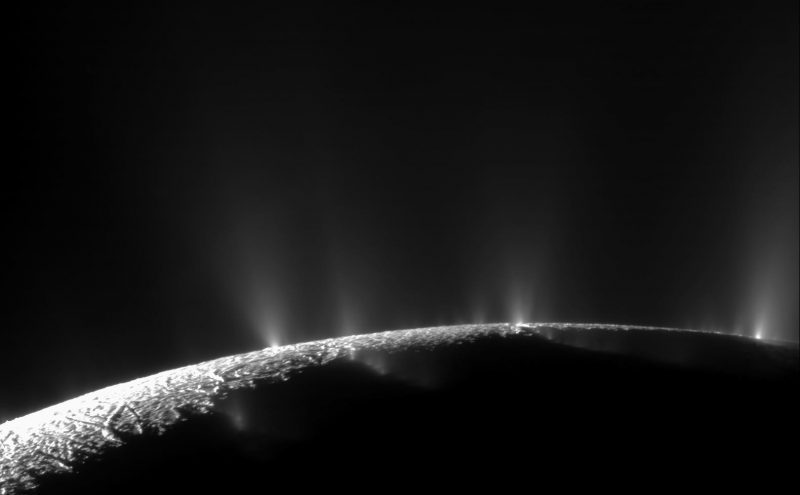
These alien geysers spew life’s building blocks

Water vapor plumes on an icy moon.

The geysers of Saturn’s moon Enceladus. These great plumes of water vapor erupt through fractures in the ice crust at this moon’s south pole. The Cassini spacecraft analyzed the plumes and found water vapor, ice particles, salts, methane and a variety of complex and simple organic molecules. Scientists think they originate from the ocean below the moon’s icy surface. Image via NASA/JPL-Caltech/Space Science Institute.

Is the subsurface ocean on Saturn’s moon Enceladus habitable? Could it be home to existing life forms? While we still don’t know the answer to the second question, evidence continues to build that this small moon’s ocean is habitable by earthly standards. On October 2, 2019, scientists announced another piece of the puzzle: the discovery of additional kinds of organic compounds that originate from Enceladus’ ocean, and were found by the Cassini spacecraft to be gushing out through geysers at the moon’s south pole. These compounds are the ingredients for amino acids, the building blocks of life on Earth.

The intriguing new peer-reviewed findings were published October 2, 2019 in the Monthly Notices of the Royal Astronomical Society.

The findings come from continued analysis of data from the Cassini mission at Saturn, which ended in 2017. The spacecraft had sampled water vapor in the huge geyser-like plumes that erupt from fractures at the south pole of the moon called Tiger Stripes. The results showed water vapor, ice grains, salts, methane and organic molecules of various sizes existing in the plumes.

Ocean under the crust of an icy moon.

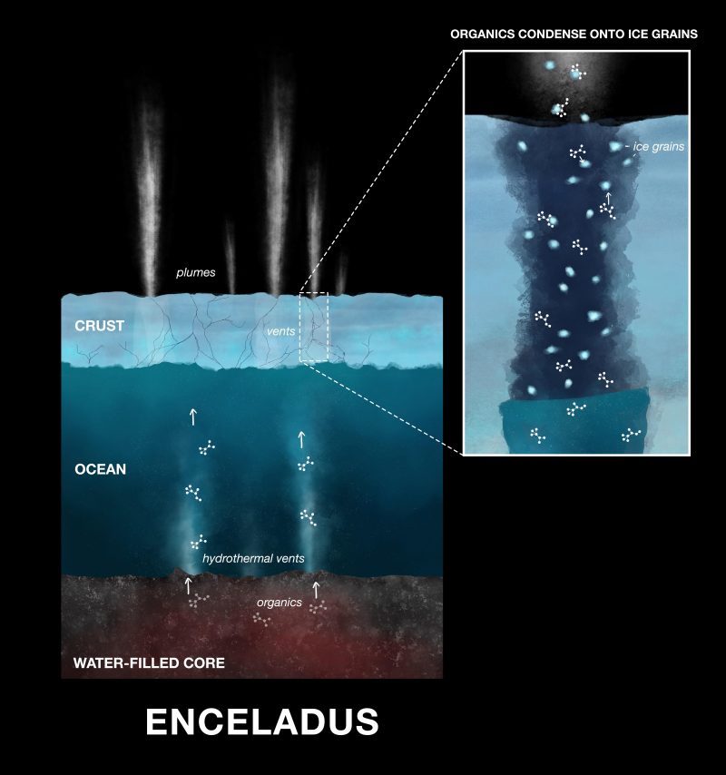
Illustration depicting how the organic compounds, originating from ocean bottom hydrothermal vents, are condensed onto ice grains in cracks in Enceladus’ crust. The ice grains and organics then get ejected into space by the water vapor plumes. Image via NASA/JPL-Caltech.

Cassini also found evidence for active hydrothermal vents on the ocean floor, similar to ones seen on the ocean bottoms of Earth. The new organic compounds were found to be nitrogen- and oxygen-bearing, condensed onto the ice grains. On Earth, those same compounds are produced by hydrothermal vents, and are part of the chemical reactions that produce amino acids. Is the same thing happening on Enceladus? As Nozair Khawaja, at the Free University of Berlin, explained:

If the conditions are right, these molecules coming from the deep ocean of Enceladus could be on the same reaction pathway as we see here on Earth. We don’t yet know if amino acids are needed for life beyond Earth, but finding the molecules that form amino acids is an important piece of the puzzle.

The ice grains from Enceladus’ plumes also get injected into Saturn’s E ring. The new compounds were found on these ice grains by Cassini’s Cosmic Dust Analyzer (CDA). The composition of the organic material was determined by the CDA’s mass spectrometer.

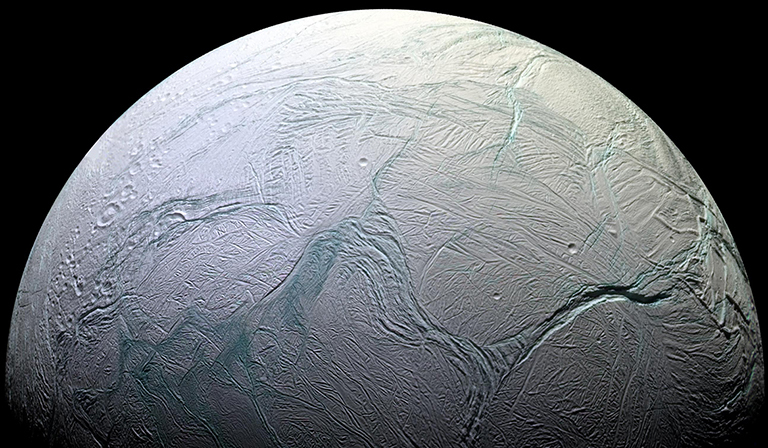
Cracks on surface of an icy moon.

Enceladus as seen by the Cassini spacecraft. This small, icy moon has a global subsurface ocean that could possibly support life. Image via NASA/JPL-Caltech/NASA Science.

So how did these and other organics get into space? First, they were dissolved in the subsurface ocean itself. They were then evaporated out of the water, condensing and freezing onto ice grains inside the fractures in the moon’s crust. As the plumes of water vapor from the ocean move upward through the fractures to the surface, they transport the ice grains and organics with them. After being injected into space, these grains can then be sampled and analyzed by spacecraft such as Cassini.

Cassini had already found found larger organic molecules in the plumes. These new compounds however, although smaller, are tied directly to the hydrothermal processes that would create amino acids. According to co-author Jon Hillier:

Here we are finding smaller and soluble organic building blocks – potential precursors for amino acids and other ingredients required for life on Earth.

Another co-author, Frank Postberg, added:

This work shows that Enceladus’ ocean has reactive building blocks in abundance, and it’s another green light in the investigation of the habitability of Enceladus.

Another recent study showed that Enceladus’ ocean is also apparently just the right age to support life.

Colored and grey balls stuck together.

Diagram of the amino acid Lysine, which has carbon atoms attached and is used in the biosynthesis of proteins. Amino acids are the building blocks of life as we know it, and now they have been discovered in Enceladus’ plumes. Image via Wikipedia/CC BY 3.0.

Black

A “black smoker” hydrothermal vent on the ocean floor on Earth. Similar vents are thought to exist on the ocean floor of Enceladus as well, where the organic compounds most likely originate from. Image via National Ocean Service (NOA).

The discovery of these smaller – but vital – organic compounds is another significant piece of the puzzle in understanding Enceladus’ possible habitability. Although completely frozen on the outside surface, on the inside, Enceladus is a most remarkable little world. Beneath the outer ice crust lies a global warm salty ocean, that, it appears, is not too different from oceans on Earth. The rocky bottom, including the hydrothermal vents, provides chemical nutrients just as it does on our planet. The environment is similar to that around hydrothermal vents – or “smokers” – on Earth’s ocean bottoms. The vents provide heat and nutrients and at least on Earth, serve as an oasis for a multitude of life forms despite the surrounding colder waters and complete lack of sunlight.

These new findings make Enceladus and other ocean moons in the solar system, such as Europa and Titan, even more enticing targets in the search for life elsewhere in the solar system. Not that long ago, it was thought that Earth was the only world in our solar system with liquid water. Now we know of several moons in the outer solar system that do as well (and maybe even Pluto!), it’s just that the water is hidden below an outer layer of ice. We don’t know yet if any of those water worlds actually host any kind of life, but being able to study some of these alien oceans both now and with more advanced future missions is certainly one of the most exciting developments in planetary exploration.

Bottom line: Further analysis of material in Enceladus’ water vapor plumes has revealed the existence of additional organic compounds, the kind that are the ingredients of amino acids, the building blocks of life on Earth.

Source: Low-mass nitrogen-, oxygen-bearing, and aromatic compounds in Enceladean ice grains

Via Jet Propulsion Laboratory


from EarthSky https://ift.tt/30YXa1T

Human embryos have extra lizard-like muscles in their hands

X-ray of translucent purple hand with muscles in white labeled dorsometacarpales.

Scan of the left hand of a 10-week-old human embryo. The dorsometacarpales are highlighted: these muscles are present in adults of many other limbed animals, while in humans they normally disappear or become fused with other muscles before birth. Image via Rui Diogo, Natalia Siomava and Yorick Gitton.

New research shows that some muscles, thought to have been abandoned by our mammalian ancestors 250 million years ago, never completely went away.

A team of evolutionary biologists have demonstrated that numerous atavistic limb muscles – remnants of anatomy that evolution never completely ditched – are actually formed during early human development and then lost prior to birth. According to the study, published October 1, 2019, in the journal Development, they are probably among the oldest, albeit fleeting, remnants of evolution yet seen in humans.

Some of these muscles, such as the dorsometacarpales shown in the image above, disappeared from our adult ancestors more than 250 million years ago – a relic from when reptiles transitioned to mammals. The scientists aren’t sure why the human body makes and then deletes them before birth.

Evolutionary biologist Rui Diogo of Howard University led the study. Diogo told the BBC:

Why are they there? Probably, we cannot just say in evolution, ‘Look, I will delete from scratch, from day zero, the muscle going to digits two, three, four, five and I will just keep the one going to the thumb.’

EarthSky’s 2020 lunar calendars are here! Get yours today. They make great gifts. Going fast.

According to a statement from the researchers about the study:

Remarkably, in both the hand and the foot, of the 30 muscles formed at about 7 weeks of gestation one third will become fused or completely absent by about 13 weeks of gestation. This dramatic decrease parallels what happened in evolution and deconstructs the myth that in both our evolution and prenatal development we tend to become more complex, with more anatomical structures such as muscles being continuously formed by the splitting of earlier muscles.

For the study, the team scanned the tissues of more than a dozen embryos and young fetuses in high-res 3D over a number of weeks. They found tiny muscles in the hands and feet in 7-week-olds that were no longer visible by week 13. The unprecedented resolution offered by the 3D images revealed the transient presence of several of such atavistic muscles, Diogo said in a statement.

It used to be that we had more understanding of the early development of fishes, frogs, chicken and mice than in our own species, but these new techniques allow us to see human development in much greater detail.

He added:

Interestingly, some of the atavistic muscles are found on rare occasions in adults, either as anatomical variations without any noticeable effect for the healthy individual, or as the result of congenital malformations. This reinforces the idea that both muscle variations and pathologies can be related to delayed or arrested embryonic development

Bottom line: Ancient reptilian “hand” muscles have been found in human embryos.

Source: Development of human limb muscles based on whole-mount immunostaining and the links between ontogeny and evolution

Via The Company of Biologists


from EarthSky https://ift.tt/3225XkJ

Watch for Sirius, sky’s brightest star

If you’re up before daybreak, take a moment to see the sky’s brightest star, Sirius, on these October mornings. This star is so brilliant that you can even see it from a light-polluted city. Click here to find out when Sirius will rise tonight from your part of the world.

Andy wrote:

Early this morning, looking southeast, I saw a beautiful star, bright and multicolored … Can you identify it for me?

And Paula wrote:

This morning two of us got up early. We found a pulsing star straight down the sky below Orion’s Belt. It was pulsing the colors of green, yellow, blue and red like a strobe light. I will search for it every morning as it was so enchanting.

This star is enchanting, so much so that – every year, beginning in Northern Hemisphere autumn – we get many, many questions about a multicolored star twinkling in the southeastern to southern sky after midnight. This star typically turns out to be Sirius, which is in the constellation Canis Major the Greater Dog and is sometimes called the Dog Star.

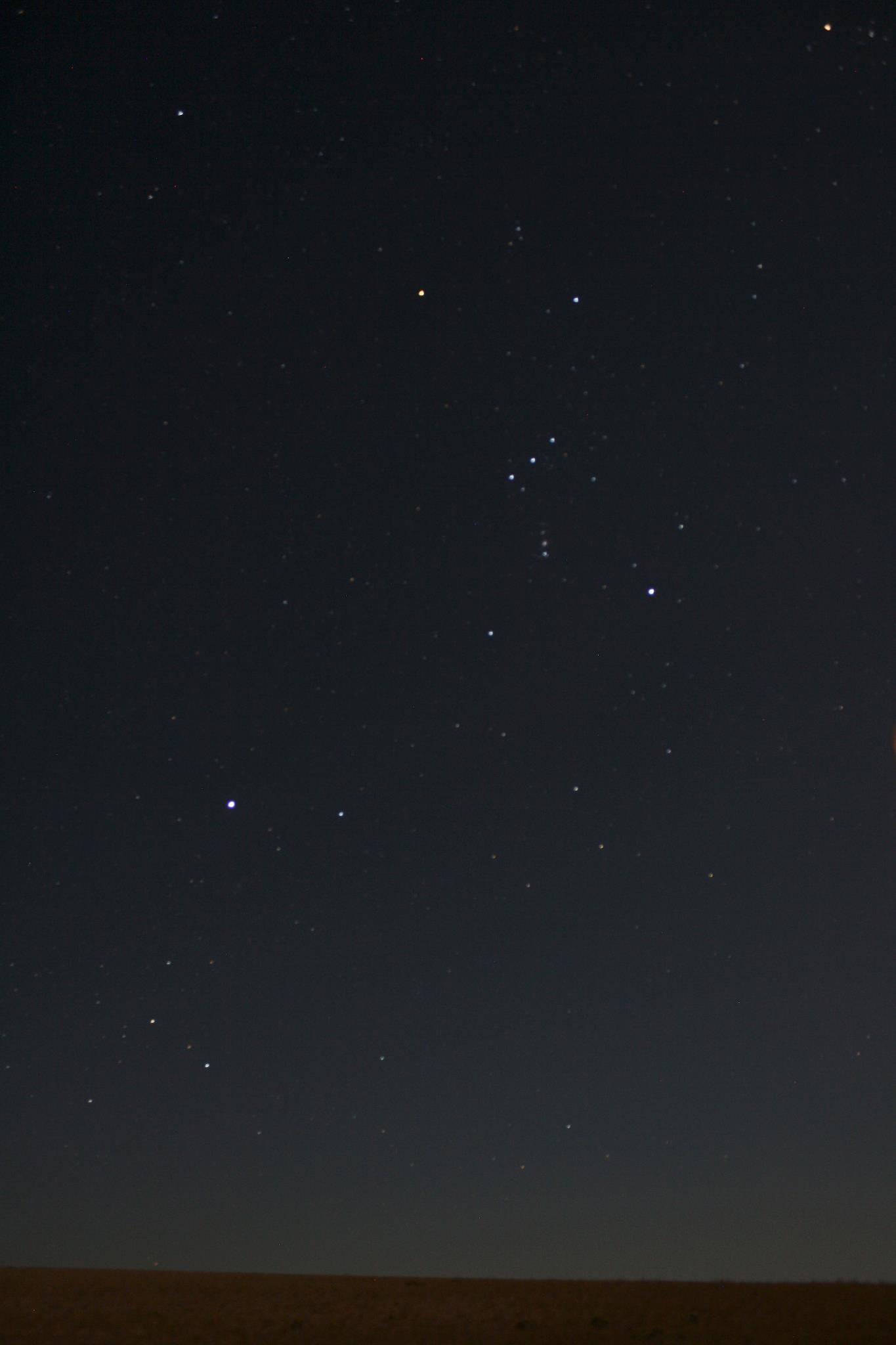
Sirius is now rising in the southeast in the hours after midnight and can be found in the south at dawn. Notice that a line from Orion’s Belt points to Sirius.

View larger. | Brightest star Sirius on left, with constellation Orion. See how three stars of Orion’s Belt point to Sirius? This photo from EarthSky Facebook friend Susan Jensen in Odessa, Washington. Thank you, Susan!

Sirius appears to flash different colors when it’s low in the sky. Really, all the stars are flashing different colors, because light is composed of all the colors of a rainbow, and the journey through our atmosphere breaks starlight into its component colors via refraction. But you don’t notice the colors of the other stars much, because they’re not as bright as Sirius, which is the brightest star visible from anywhere on Earth.

Since our atmosphere is causing the light to break into its colors, and since Sirius is often seen low in the sky now (where you are peering at it through a thicker layer of atmosphere than when it’s overhead), the flashing colors of Sirius are very obvious. When Sirius is higher in the sky – which it is close to dawn in the month of October – or in the evening sky in January and February – you’ll find that Sirius shines with a steadier, whiter light.

So, on these October mornings, watch as Sirius winks at you in the wee hours before dawn!

More about Sirius: Dog Star and brightest star

Bottom line: We get many questions about a bright, colorful, twinkling star on these October mornings. It’s the star Sirius in the constellation Canis Major, brightest star in the sky. The bright planet Venus is also up before dawn now. But you’ll know Sirius, because Orion’s Belt always points to it.

Donate: Your support means the world to us


from EarthSky https://ift.tt/2AV8RvU

Curiosity finds an ancient oasis on Mars

The video above provides concise background on insights obtained so far via NASA’s Curiosity rover, which has been exploring Gale crater on Mars since 2012. Curiosity has joined other Mars explorers in providing evidence that the red planet must once have been warmer and wetter, likely with liquid water on its surface. Could life have gotten a foothold there? Maybe, and that’s part of what has scientists so intrigued. This week (October 7, 2019), Curiosity scientists at NASA’s Jet Propulsion Laboratory in Pasadena, California, announced another new study about Mars water, published in the peer-reviewed journal Nature Geoscience. A statement about the new work painted a vivid picture of Mars, billions of years ago:

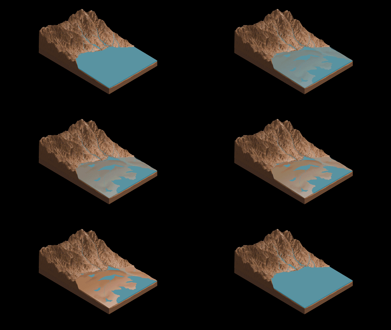
Imagine ponds dotting the floor of Gale Crater, the 100-mile-wide (150-kilometer-wide) ancient basin that Curiosity is exploring. Streams might have laced the crater’s walls, running toward its base. Watch history in fast forward, and you’d see these waterways overflow then dry up, a cycle that probably repeated itself numerous times over millions of years.

That is the landscape described by Curiosity scientists …

The authors of the new paper interpret the rocks found by Curiosity – enriched in mineral salts – as evidence of shallow briny ponds that existed on Mars’ surface billions of years ago. The rocks provide evidence that these ponds on Mars went through episodes of overflow and drying. NASA commented:

The deposits serve as a watermark created by climate fluctuations as the Martian environment transitioned from a wetter one to the freezing desert it is today.

The lunar calendars are here! Get your 2020 lunar calendars today. They make great gifts. Going fast!

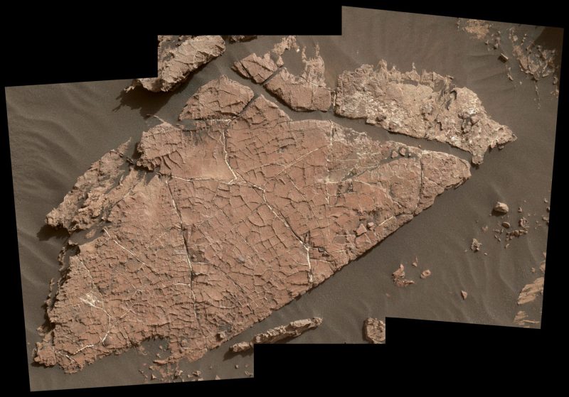
This is rock, but it looks like a dry lake bed with many narrow right-angled cracks.

View larger. | Possible mud cracks preserved in Martian rock. Earthly scientists call this Martian rock slab Old Soaker. It might have formed from the drying of a mud layer more than 3 billion years ago. The view spans about 4 feet (1.2 meters) left-to-right and combines three images taken by the Mars Hand Lens Imager (MAHLI) camera on the arm of NASA’s Curiosity Mars rover. Read more about this image.

William Rapin of Caltech is the lead author of the new paper. He said:

We went to Gale Crater because it preserves this unique record of a changing Mars. Understanding when and how the planet’s climate started evolving is a piece of another puzzle: When and how long was Mars capable of supporting microbial life at the surface?

Rapin and his co-authors describe salts found across a 500-foot-tall (150-meter-tall) section of sedimentary rocks called Sutton Island, which Curiosity visited in 2017. The mud cracks at one location look so much like a dry lakebed that the scientists have nicknamed the location Old Soaker. NASA said:

… the team already knew the area had intermittent drier periods. But the Sutton Island salts suggest the water also concentrated into brine.

Typically, when a lake dries up entirely, it leaves piles of pure salt crystals behind. But the Sutton Island salts are different: For one thing, they’re mineral salts, not table salt. They’re also mixed with sediment, suggesting they crystallized in a wet environment – possibly just beneath evaporating shallow ponds filled with briny water.

Given that Earth and Mars were similar in their early days, Rapin speculated that Sutton Island might have resembled saline lakes on South America’s Altiplano [in west-central South America, the place where the Andes are widest]. Streams and rivers flowing from mountain ranges into this arid, high-altitude plateau lead to closed basins similar to Mars’ ancient Gale Crater. Lakes on the Altiplano are heavily influenced by climate in the same way as Gale.

Rapin added:

During drier periods, the Altiplano lakes become shallower, and some can dry out completely. The fact that they’re vegetation-free even makes them look a little like Mars.

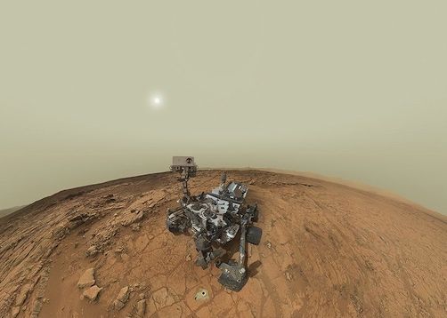
Complex wheeled machine on light-brown rocky landscape against cloudy sky with sun shining through.

View as panorama. | This self-portrait of NASA’s Mars rover Curiosity combines 66 exposures taken by the rover’s MAHLI imaging system during the 177th Martian day, or sol, of Curiosity’s work on Mars (February 3, 2013).

Curiosity’s science team is now seeing a cycle of wet-to-dry across long timescales on Mars. Project Scientist Ashwin Vasavada of JPL said:

As we climb Mount Sharp, we see an overall trend from a wet landscape to a drier one. But that trend didn’t necessarily occur in a linear fashion. More likely, it was messy, including drier periods, like what we’re seeing at Sutton Island, followed by wetter periods…

Read more about this new study via NASA/JPL-Caltech

A portion of a Martian lake next to a hill, where blue water slowly dries and dry land emerges.

This animation illustrates the Sutton Island model of drying lakes on Mars. Sutton Island is a 500-foot-tall (150-meter-tall) section of sedimentary rocks on Mount Sharp – the central mountain in Gale Crater – where Curiosity has been exploring since 2012. The model suggests stream flow from Mount Sharp to the floor of Gale Crater. Salty ponds might have been left behind as the region dried out over time. The rocks enriched with mineral salts, found here by Curiosity, suggest that water vanished slowly, and they suggest a possible, persistent cycle of drying and overflow. Image via ASU Knowledge Enterprise Development/Michael Northrop/NASA.

Bottom line: Scientists working with the Curiosity rover have found salt-enriched rock at a place called Sutton Island on Mars. The rocks suggest ponds with briny water existed on Mars, billions of years ago.

Source: An interval of high salinity in ancient Gale crater lake on Mars


from EarthSky https://ift.tt/2MoP4KI

10 amazing places for year-round stargazing

Silhouette of man standing on enormous rock with Milky Way rising in deep twilight.

Joshua Trees White Tank Campground, in the U.S. state of California. As well as being in the darkest region of the park, it’s nestled among huge granite boulders that are ideal for standing on, as you can see in this image of the bright core of the Milky Way taken on a late September evening, just after dark. The park’s huge population of Joshua trees – a kind of yucca – are also just as attractive as foreground objects. Image via Chris Grant.

We can all look up and appreciate an exceptionally bright moon or a surprisingly clear night. But sadly, the increase in worldwide light pollution makes it more difficult to see the stars, the moon, planets and deep-sky objects like galaxies and globular clusters. To help combat this issue, Trover, a travel photography platform, have joined together with astronomy expert and journalist Jamie Carter, to find 10 amazing year-round stargazing spots for a definitive stargazing travel bucket list – along with some astrophotography tips too.

1. Joshua Tree National Park, California, U.S.

Fancy a selfie with the stars? It’s become fashionable among astrophotographers to set up a shot and then go stand in it. If you want to give it go, get yourself down to White Tank Campground at the northern end of Joshua Tree National Park, a huge wilderness in southern California beloved of astrophotographers and stargazers.

Joshua Tree National Park’s darkness is extra-precious. The last pool of natural darkness in southern California, it’s now an International Dark Sky Park. That should help protect it for the populations of Los Angeles and San Diego, for which Joshua Tree is the nearest practical place to experience darkness. White Tank Campground and Cottonwood Campground have the darkest skies here.

The lunar calendars are here! Get your 2020 lunar calendars today. They make great gifts. Going fast!

The lunar calendars are here! Get your 2020 lunar calendars today. They make great gifts. Going fast!

Star field with bright reddish dot to left and verticle cloudy Milky Way.

Acadia National Park, in the U.S. state of Maine. In this image you’ll find a vertical Milky Way and, to its left, Mars, as seen from this dark sky destination on the U.S. eastern seaboard. Look in the center of the picture and you can even see Saturn about to sink behind the forest. This image, which we believe was taken in 2018, is via RVOutlawz.

2. Acadia National Park, Maine, U.S.

September is probably the best month of the year at Acadia for stargazing and astrophotography (which is the photography of astrological and celestial objects in the night sky). Not only is it warm enough to stand around in short sleeves and look at the stars, but the Milky Way is also visible soon after sunset.

The planets are visible at different times depending on the year, but views like this of the Milky Way can be enjoyed every summer and early autumn. It’s no surprise then that every September the region hosts the Acadia Night Sky Festival. Held throughout Acadia National Park, Bar Harbor, Mount Desert Island and the Schoodic Peninsula, it includes activities and events ranging from expert talks on asteroids and the Milky Way to a boat cruise that teaches guests how to navigate using only the constellations.

Experience for yourself: If you’re after true and total darkness, take a mailboat to Acadia National Park’s Duck Harbor Campground on Isle au Haut, which has five primitive campsites. It’s also a nice place to hike.

Tall saguaro cactuses silhouetted against star field with Milky Way running left to right.

Saguaro National Park, in the U.S. state of Arizona. In this image, a tenuous Milky Way streams across the sky in the early hours of an April night. For a totally different kind of photo, get yourself here for dusk on November 24, 2019, and you could capture the rare close conjunction of Venus and Jupiter, when the two brightest planets will be just 1.4 degrees apart for one night only. You’ll need a composition that allows you to look low to the western horizon, and you’ll need to be in place at sunset. Image via Richard Remington.

3. Saguaro National Park, Arizona, USA

Astrophotography is not just about photographing the stars – photographs containing only stars are typically not very interesting. The perfect nightscape photo is one that also includes a strong foreground. Cue Saguaro National Park. Close to Tucson, Arizona, it’s home to Saguaro, the largest species cactus in the USA.

Finding something to put in the foreground of your astro-image doesn’t get any easier than this, though what you choose to put behind saguaro will depend on what’s visible when you’re there.

Experience for yourself: Come at dusk on February 9, March 9 and April 8, 2020 and you can capture a fabulous supermoon, appearing between saguaro, in the eastern sky.

Dark mountains in distance, tall evergreens in foreground against sky with colorful phenomena.

If you notice something green in the night sky above Mount Rainier National Park, don’t be alarmed. It’s not the Northern Lights. In this incredible photo taken in summer from the Sunrise Rim Trail it’s possible to see what is known as airglow, the natural glow of the Earth’s atmosphere. On the left is the summer Milky Way streaming towards the horizon, and on the right is a meteor – also known as a shooting star – from July’s Delta Aquariid meteor shower. Image via Noel Benadom.

4. Mount Rainier National Park, Washington, U.S.

The active volcano that dominates Mount Rainier National Park can get another kind of green glow during the winter months, too. Although its latitude of 47° N puts it far from the Arctic Circle – where the aurora borealis usually hangs out – during extra-strong displays the ‘green lady’ can move south and sometimes be glimpsed on the northern horizon from here.

Experience for yourself: A great observing spot at Mount Rainier National Park is Sunrise Point. The highest point in the park it’s reachable by car at 6,400 feet (1,950 meters).

Milky Way arcing across star field above dark woods.

Cherry Springs State Park. Image via Ricky Batista.

5. Cherry Springs State Park, Pennsylvania, USA

Talk to any astrophotographer in or around New England about where they go to shoot the stars, and they’ll all say the same thing: Cherry Springs State Park in north-central Pennsylvania.

Just a few hours’ drive from massive population centers like Boston, New York City and Washington DC, and yet surrounded by the largely undeveloped Susquehannock State Forest, Cherry Springs can get really busy from about April (which is when the above image of the Milky Way was shot).

Experience for yourself: It’s popular at this time of the year because of its incredible dark sky conditions and facilities for stargazers, astronomers and astrophotographers. The draw is its Overnight Astronomy Observation Field. Perched at the top of a 2,300 feet (700 meters) high mountain, if offers a 360-degree view of the night sky for those who register in advance. It also regularly hosts star parties. Nearby you’ll find the Cherry Springs campground and another separate night sky viewing area.

Cherry Springs is also a ‘gold tier’ International Dark Sky Park, a designation from the International Dark Sky Association of only the very darkest locations in the world.

Star field with Milky Way and thin white streak on left of an old mining structure.

On the right of the image is what may look like a shooting star to the untrained eye. In fact, it’s an airplane. To capture shooting stars in astro-photos isn’t easy, but you can maximize your chances by heading somewhere with dark skies during a meteor shower. Image via David Mears.

6. Death Valley National Park, California, U.S.

Harmony Borax Works at Furnace Creek in Death Valley National Park is something of a favorite among astrophotographers – and it’s easy to see why from this photo taken before sunrise on an April morning. Once again it shows why composition is so important in creating a great nightscape photo.

Experience for yourself: Death Valley National Park is the perfect location. There are dozens of minor celestial ‘storms’ throughout the year, but the big meteor showers to lookout for are the Orionids (October 21–22 2019), Taurids (November 5–6, 2019), Leonids (November 17–18 2019), but especially the Geminids (December 13–14 2019). The ‘king of the meteor showers’, the Geminids can produce up to 120 marvelous multicolored meteors per hour.

Star field with faint Milky Way above large sihouetted rock formations.

As this image of a rich star field in October reveals, the night sky at Arches National Park is a photographer’s dream for the endless compositions it offers – here the stars form a glittering background to a silhouette of sandstone rock formations. Image via Howard S.

7. Arches National Park, Utah, U.S.

Utah has an embarrassment of riches for anyone who wants to look up at a night sky. With vast national parks like Canyonlands National Park, Natural Bridges National Monument, and Hovenweep National Monument, and a super-low population density, this dry, arid area is a cosmic playground.

None more so than Arches National Park, which in July 2019 was at last given the status of an International Dark Sky Park. The park rangers here have been committed to teaching about its precious dark skies for years.

Arches has – you guessed it – dozens of delicate weather-eroded rock arches that can act as an unlikely frame for stars, planets and the Milky Way. You’ll find all the rock formations you want within walking distance of the Devil’s Garden Campground.

Large dark tree against starfield with lit-up tent at its base.

This image was taken at the remote Karijini National Park during April’s Karijini Experience, a festival celebrating the culture of the local Banjima people. The next one will be held from April 14-18, 2020, just days before the Lyrids Meteor Shower. Image via Lauren Blath.

8. Karijini National Park, Western Australia

The southern hemisphere gets a completely different view of the night sky, including some sights that those in the northern hemisphere never see. In the above image, you can see a great example of that: the Milky Way’s bright core. You have to be in the southern hemisphere to see our own galaxy’s center at its brightest. It’s best viewed from a remote dark sky destination like Karijini National Park in Western Australia between April and November.

Stand outside on a clear night and there are so many stars that it’s easy to see why aboriginal culture doesn’t bother with describing stars and constellations, but rather sees only the gaps between them. The most famous is the Emu, a dark shape stretching from the Southern Cross along the Milky Way’s Great Rift of overlapping dust clouds obscuring the stars.

Field of brilliant stars over an ochre-colord building with a large deck around it.

Image via The Kiwi Frog.

9. Aoraki/Mount Cook National Park, New Zealand

One of the most beautiful hikes in all of New Zealand, the Mueller Hut Track also gives some terrific panoramic views of Aoraki/Mount Cook National Park – and the night sky above, of course. This image is the perfect example of why every stargazer, astronomer and astrophotographer must venture to the southern hemisphere at some point.

Yes, the Milky Way is brighter, but focus your gaze on the right-hand side of the above image you’ll see two objects that are impossible to see from north of the equator: the Large Magellanic Cloud and the Small Magellanic Cloud. Dwarf galaxies orbiting the Milky Way, they each contain billions of stars, and their appearance in night sky photographs are a hallmark of an adventurous sky-watcher.

Experience for yourself: The Large Magellanic Cloud and the Small Magellanic Cloud are best seen between December and April from New Zealand, Australia, southern Africa and South America.

Dense star field with Milky Way with dark rifts clearly visible.

This image was taken in the Atacama Desert during the month of April when the Milky Way becomes visible at night. With the full moon drifting into Earth’s central shadow, the bright moon dulled, then went red, leaving our incredible galaxy visible for just a few hours. That won’t happen again until 2021, but there is a penumbral lunar eclipse on January 10, 2020, when a full moon will drift into the Earth’s outer shadow and suddenly lose its brightness. However, it won’t go red. Image via drinkwildair.

10. Atacama Desert, Chile

Why do stars twinkle? Technically they don’t, but the closer you are to sea-level, the hotter the air you are stargazing through – which distorts everything and makes stars look like they’re twinkling.

There is an easy way to get above all that hot air – go to the Atacama Desert in northern Chile. Here, in one of the driest, highest and clearest skies in the world is the small town of San Pedro de Atacama. A stargazing mecca on an arid high plateau at over 6,500ft/2,000m, it’s close to some boutique observatory-hotels, including Alto, Explora Atacama and Observatorio Alarkapin.

It’s normally not recommended to go anywhere famed for its dark skies – such as the Atacama Desert – while there’s a full moon. Why? Well, the full moon is the biggest light-polluter of all, so the bigger and brighter it is, the fainter the stars will appear. However, there is one exception and that’s during a total lunar eclipse.

Bottom line: Ten great dark-sky places for skywatching and stargazing.

Via Jamie Carter/Trover.

Visit EarthSKy’s Best Places to Stargaze page for dark locations near you


from EarthSky https://ift.tt/2ICIKxX

Saturn is our solar system’s new moon king

On Monday (October 7, 2019), the International Astronomical Union’s Minor Planet Center announced the discovery of 20 new moons orbiting Saturn, bringing the planet’s total number of moons to 82. That surpasses Jupiter, which has 79, and makes Saturn the planet with the most known moons in our solar system.

Scientists discovered the new moons using the Subaru telescope atop Mauna Kea in Hawaii. Scott Sheppard of Carnegie Institution for Science led the discovery team. He said in a statement:

Using some of the largest telescopes in the world, we are now completing the inventory of small moons around the giant planets. They play a crucial role in helping us determine how our solar system’s planets formed and evolved.

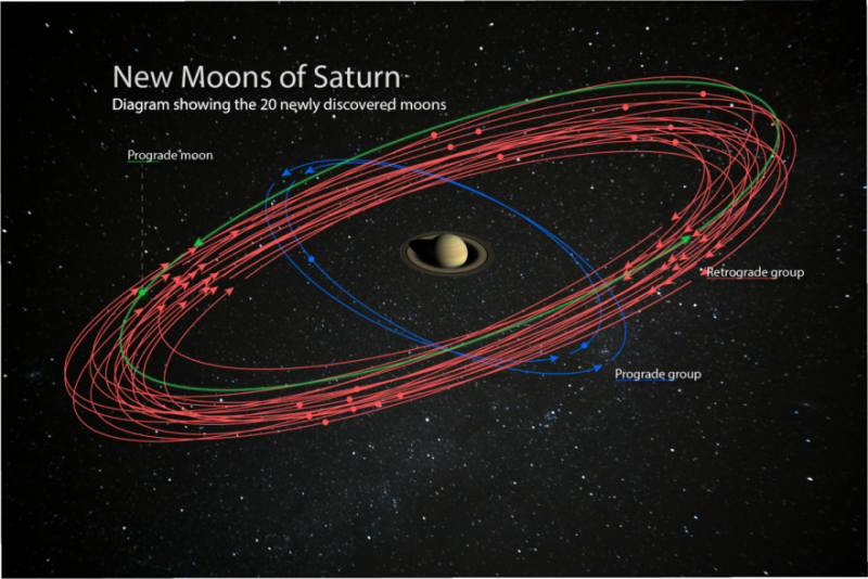
Red lines encircling a ball

An artist’s concept of the 20 newly discovered moons orbiting Saturn. These discoveries bring the planet’s total moon count to 82, surpassing Jupiter for the most in our solar system. Image via the Carnegie Institution for Science. (Saturn image is courtesy of NASA/JPL-Caltech/Space Science Institute. Starry background courtesy of Paolo Sartorio/Shutterstock.)

EarthSky lunar calendars are here! Get your 2020 lunar calendars today. They make great gifts. Going fast.

According to the researchers, each of the newly discovered moons is about 3 miles (5 km) in diameter. Seventeen of them orbit Saturn backwards, or in a retrograde direction, meaning their movement is opposite to the planet’s rotation around its axis. One of the newly discovered retrograde moons is the farthest known moon around Saturn.

The other three moons orbit in the same direction as Saturn rotates. Two of these three moons are closer to the planet and take about two years to travel once around Saturn. The third, and the more-distant retrograde moons, each take more than three years to complete an orbit.

The outer moons of Saturn appear to be grouped into three different clusters, according to how they orbit the planet. The newly discovered retrograde moons appear to belong to a group of moons, named after Norse mythology, thought to be fragments of a much bigger parent moon that was smashed to pieces in the solar system’s violent past. Sheppard said:

This kind of grouping of outer moons is also seen around Jupiter, indicating violent collisions occurred between moons in the Saturnian system or with outside objects such as passing asteroids or comets.

Sheppard added:

In the solar system’s youth, the sun was surrounded by a rotating disk of gas and dust from which the planets were born. It is believed that a similar gas-and-dust disk surrounded Saturn during its formation. The fact that these newly discovered moons were able to continue orbiting Saturn after their parent moons broke apart indicates that these collisions occurred after the planet-formation process was mostly complete and the disks were no longer a factor.

The Carnegie Institution for Sciences is hosting a contest to come up with names for the newly discovered moons. The moons must be named after giants from Norse, Gallic, or Inuit mythology. Contest details are here. Here’s a video about the contest:

Bottom line: Astronomers have found 20 new moons orbiting Saturn, bringing the planet’s total number of moons to 82.

Via the Carnegie Institution for Science


from EarthSky https://ift.tt/2nvH2ap