The video above provides concise background on insights obtained so far via NASA’s Curiosity rover, which has been exploring Gale crater on Mars since 2012. Curiosity has joined other Mars explorers in providing evidence that the red planet must once have been warmer and wetter, likely with liquid water on its surface. Could life have gotten a foothold there? Maybe, and that’s part of what has scientists so intrigued. This week (October 7, 2019), Curiosity scientists at NASA’s Jet Propulsion Laboratory in Pasadena, California, announced another new study about Mars water, published in the peer-reviewed journal Nature Geoscience. A statement about the new work painted a vivid picture of Mars, billions of years ago:
Imagine ponds dotting the floor of Gale Crater, the 100-mile-wide (150-kilometer-wide) ancient basin that Curiosity is exploring. Streams might have laced the crater’s walls, running toward its base. Watch history in fast forward, and you’d see these waterways overflow then dry up, a cycle that probably repeated itself numerous times over millions of years.
That is the landscape described by Curiosity scientists …
The authors of the new paper interpret the rocks found by Curiosity – enriched in mineral salts – as evidence of shallow briny ponds that existed on Mars’ surface billions of years ago. The rocks provide evidence that these ponds on Mars went through episodes of overflow and drying. NASA commented:
The deposits serve as a watermark created by climate fluctuations as the Martian environment transitioned from a wetter one to the freezing desert it is today.

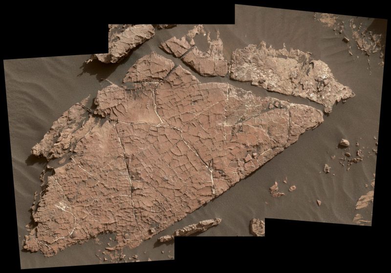
View larger. | Possible mud cracks preserved in Martian rock. Earthly scientists call this Martian rock slab Old Soaker. It might have formed from the drying of a mud layer more than 3 billion years ago. The view spans about 4 feet (1.2 meters) left-to-right and combines three images taken by the Mars Hand Lens Imager (MAHLI) camera on the arm of NASA’s Curiosity Mars rover. Read more about this image.
William Rapin of Caltech is the lead author of the new paper. He said:
We went to Gale Crater because it preserves this unique record of a changing Mars. Understanding when and how the planet’s climate started evolving is a piece of another puzzle: When and how long was Mars capable of supporting microbial life at the surface?
Rapin and his co-authors describe salts found across a 500-foot-tall (150-meter-tall) section of sedimentary rocks called Sutton Island, which Curiosity visited in 2017. The mud cracks at one location look so much like a dry lakebed that the scientists have nicknamed the location Old Soaker. NASA said:
… the team already knew the area had intermittent drier periods. But the Sutton Island salts suggest the water also concentrated into brine.
Typically, when a lake dries up entirely, it leaves piles of pure salt crystals behind. But the Sutton Island salts are different: For one thing, they’re mineral salts, not table salt. They’re also mixed with sediment, suggesting they crystallized in a wet environment – possibly just beneath evaporating shallow ponds filled with briny water.
Given that Earth and Mars were similar in their early days, Rapin speculated that Sutton Island might have resembled saline lakes on South America’s Altiplano [in west-central South America, the place where the Andes are widest]. Streams and rivers flowing from mountain ranges into this arid, high-altitude plateau lead to closed basins similar to Mars’ ancient Gale Crater. Lakes on the Altiplano are heavily influenced by climate in the same way as Gale.
Rapin added:
During drier periods, the Altiplano lakes become shallower, and some can dry out completely. The fact that they’re vegetation-free even makes them look a little like Mars.

View as panorama. | This self-portrait of NASA’s Mars rover Curiosity combines 66 exposures taken by the rover’s MAHLI imaging system during the 177th Martian day, or sol, of Curiosity’s work on Mars (February 3, 2013).
Curiosity’s science team is now seeing a cycle of wet-to-dry across long timescales on Mars. Project Scientist Ashwin Vasavada of JPL said:
As we climb Mount Sharp, we see an overall trend from a wet landscape to a drier one. But that trend didn’t necessarily occur in a linear fashion. More likely, it was messy, including drier periods, like what we’re seeing at Sutton Island, followed by wetter periods…
Read more about this new study via NASA/JPL-Caltech

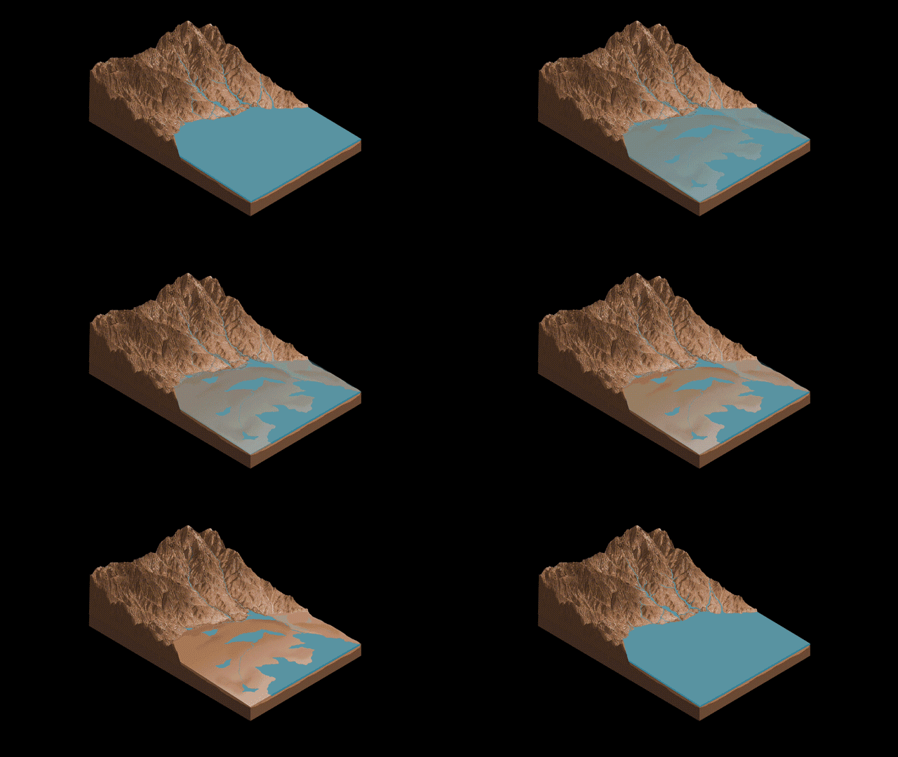
This animation illustrates the Sutton Island model of drying lakes on Mars. Sutton Island is a 500-foot-tall (150-meter-tall) section of sedimentary rocks on Mount Sharp – the central mountain in Gale Crater – where Curiosity has been exploring since 2012. The model suggests stream flow from Mount Sharp to the floor of Gale Crater. Salty ponds might have been left behind as the region dried out over time. The rocks enriched with mineral salts, found here by Curiosity, suggest that water vanished slowly, and they suggest a possible, persistent cycle of drying and overflow. Image via ASU Knowledge Enterprise Development/Michael Northrop/NASA.
Bottom line: Scientists working with the Curiosity rover have found salt-enriched rock at a place called Sutton Island on Mars. The rocks suggest ponds with briny water existed on Mars, billions of years ago.
Source: An interval of high salinity in ancient Gale crater lake on Mars
from EarthSky https://ift.tt/2MoP4KI

The video above provides concise background on insights obtained so far via NASA’s Curiosity rover, which has been exploring Gale crater on Mars since 2012. Curiosity has joined other Mars explorers in providing evidence that the red planet must once have been warmer and wetter, likely with liquid water on its surface. Could life have gotten a foothold there? Maybe, and that’s part of what has scientists so intrigued. This week (October 7, 2019), Curiosity scientists at NASA’s Jet Propulsion Laboratory in Pasadena, California, announced another new study about Mars water, published in the peer-reviewed journal Nature Geoscience. A statement about the new work painted a vivid picture of Mars, billions of years ago:
Imagine ponds dotting the floor of Gale Crater, the 100-mile-wide (150-kilometer-wide) ancient basin that Curiosity is exploring. Streams might have laced the crater’s walls, running toward its base. Watch history in fast forward, and you’d see these waterways overflow then dry up, a cycle that probably repeated itself numerous times over millions of years.
That is the landscape described by Curiosity scientists …
The authors of the new paper interpret the rocks found by Curiosity – enriched in mineral salts – as evidence of shallow briny ponds that existed on Mars’ surface billions of years ago. The rocks provide evidence that these ponds on Mars went through episodes of overflow and drying. NASA commented:
The deposits serve as a watermark created by climate fluctuations as the Martian environment transitioned from a wetter one to the freezing desert it is today.

View larger. | Possible mud cracks preserved in Martian rock. Earthly scientists call this Martian rock slab Old Soaker. It might have formed from the drying of a mud layer more than 3 billion years ago. The view spans about 4 feet (1.2 meters) left-to-right and combines three images taken by the Mars Hand Lens Imager (MAHLI) camera on the arm of NASA’s Curiosity Mars rover. Read more about this image.
William Rapin of Caltech is the lead author of the new paper. He said:
We went to Gale Crater because it preserves this unique record of a changing Mars. Understanding when and how the planet’s climate started evolving is a piece of another puzzle: When and how long was Mars capable of supporting microbial life at the surface?
Rapin and his co-authors describe salts found across a 500-foot-tall (150-meter-tall) section of sedimentary rocks called Sutton Island, which Curiosity visited in 2017. The mud cracks at one location look so much like a dry lakebed that the scientists have nicknamed the location Old Soaker. NASA said:
… the team already knew the area had intermittent drier periods. But the Sutton Island salts suggest the water also concentrated into brine.
Typically, when a lake dries up entirely, it leaves piles of pure salt crystals behind. But the Sutton Island salts are different: For one thing, they’re mineral salts, not table salt. They’re also mixed with sediment, suggesting they crystallized in a wet environment – possibly just beneath evaporating shallow ponds filled with briny water.
Given that Earth and Mars were similar in their early days, Rapin speculated that Sutton Island might have resembled saline lakes on South America’s Altiplano [in west-central South America, the place where the Andes are widest]. Streams and rivers flowing from mountain ranges into this arid, high-altitude plateau lead to closed basins similar to Mars’ ancient Gale Crater. Lakes on the Altiplano are heavily influenced by climate in the same way as Gale.
Rapin added:
During drier periods, the Altiplano lakes become shallower, and some can dry out completely. The fact that they’re vegetation-free even makes them look a little like Mars.

View as panorama. | This self-portrait of NASA’s Mars rover Curiosity combines 66 exposures taken by the rover’s MAHLI imaging system during the 177th Martian day, or sol, of Curiosity’s work on Mars (February 3, 2013).
Curiosity’s science team is now seeing a cycle of wet-to-dry across long timescales on Mars. Project Scientist Ashwin Vasavada of JPL said:
As we climb Mount Sharp, we see an overall trend from a wet landscape to a drier one. But that trend didn’t necessarily occur in a linear fashion. More likely, it was messy, including drier periods, like what we’re seeing at Sutton Island, followed by wetter periods…
Read more about this new study via NASA/JPL-Caltech

This animation illustrates the Sutton Island model of drying lakes on Mars. Sutton Island is a 500-foot-tall (150-meter-tall) section of sedimentary rocks on Mount Sharp – the central mountain in Gale Crater – where Curiosity has been exploring since 2012. The model suggests stream flow from Mount Sharp to the floor of Gale Crater. Salty ponds might have been left behind as the region dried out over time. The rocks enriched with mineral salts, found here by Curiosity, suggest that water vanished slowly, and they suggest a possible, persistent cycle of drying and overflow. Image via ASU Knowledge Enterprise Development/Michael Northrop/NASA.
Bottom line: Scientists working with the Curiosity rover have found salt-enriched rock at a place called Sutton Island on Mars. The rocks suggest ponds with briny water existed on Mars, billions of years ago.
Source: An interval of high salinity in ancient Gale crater lake on Mars
from EarthSky https://ift.tt/2MoP4KI

Aucun commentaire:
Enregistrer un commentaire