Using 3-D models in the search for Mars life

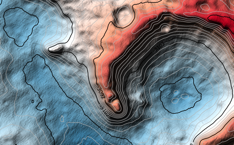
Elevation lines on map.

Here’s a piece of one of the new 3-D models just created to help ESA’s Rosalind Franklin rover explore Mars in 2021. The models are so detailed that they show, for example, as dune ripples inside craters, as you see here. Image via TU Dortmund/ NASA/ JPL-Caltech/ Europlanet.

How do modern-day space explorers prepare to search an unknown terrain? Never mind that the explorers are robots, and that the preparers are space scientists and engineers. Next summer, an ambitious new mission to Mars is scheduled to launch. The ExoMars mission of the European Space Agency (ESA) will carry the robotic Rosalind Franklin rover to Mars. The rover will search for evidence of past Martian life in Oxia Planum, a large plain rich in clays and containing an old river delta. How do they prepare? A team of scientists at TU Dortmund University in Germany has created extremely detailed 3-D models of the landing location. These scientists said on September 16, 2019 that they want to use the models to understand the geography and geological characteristics of this unexplored region on Mars, and to help plan the path of the rover.

The 3-D models are called Digital Terrain Models (DTMs). They’re a variation of Digital Elevation Models (DEMs) used by space scientists to understand planets, moons and asteroids. These particular maps have a resolution of about 25 centimeters per pixel. One of scientists, Kay Wohlfarth, presented them at last week’s international meeting of astronomers in Geneva, Switzerland.

So how were the models created?
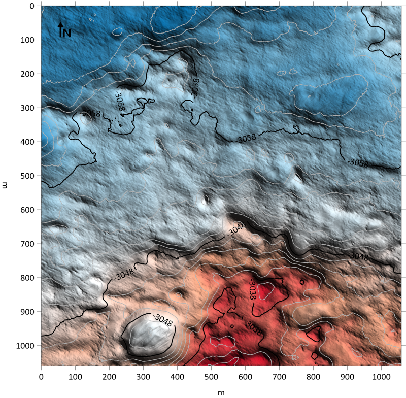
Colored elevation map.

One of the test 3-D models of terrain on Mars. Image via TU Dortmund/NASA/JPL-Caltech/Europlanet Society.
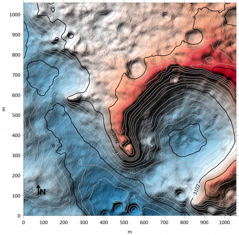
Colorful elevation map.

Another test 3-D models of terrain on Mars. Image via TU Dortmund/NASA/JPL-Caltech/Europlanet Society.

First, they use high-resolution imagery of Mars’ surface from the HiRISE camera on NASA’s Mars Reconnaissance Orbiter (MRO). That imagery is then applied to the classic stereo method of combining two images taken from slightly different angles, in order to create a 3D image of the landscape. But those kinds of stereo techniques can be limited when it comes to dusty and sandy surfaces – basically featureless – in locations like the Rosalind Franklin landing site, Oxia Planum. By necessity, the landing site is relatively flat to help ensure a safe landing.

The DTMs were then further enhanced by using a technique called Shape from Shading in which the intensity of reflected light in the image is translated into information on surface slopes. The slope data is combined with the stereo imagery, providing a much better estimate of the 3-D surface, while achieving the best resolution possible in the reconstructed landscape.

The resulting models give the scientists a much more detailed view of the landing region. As Wohlfarth explained:

With the technique, even small-scale details such as dune ripples inside craters and rough bedrock can be reproduced.
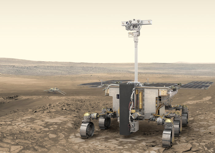
Rover on Mars.

Artist’s illustration of the Rosalind Franklin rover on Mars, part of ESA’s ExoMars mission. Image via ESA/ATG medialab.

Marcel Hess, first author of the study, said:

We have taken special care over the interaction between light and the Martian surface. Areas that are tilted towards the sun appear brighter and areas that are facing away appear darker. Our approach uses a joint reflectance and atmospheric model that incorporates reflection by the surface as well as atmospheric effects that diffuse and scatter light.

These new models will be a great aid to the rover as it navigates the landscape, looking for the best places to study with its array of instruments. Not only will the rover examine rocks and soil, it will also be able to drill up to two meters (six feet) into the subsurface, searching for possible biosignatures, chemical traces of past life. Samples will be delivered to the on-board laboratory for analysis.

PanCam, with its stereo and high-resolution cameras, will provide detailed views of interesting features in both visible and near-infrared wavelengths. Spectrometers will determine what rocks are composed of, and how much they were affected by water.
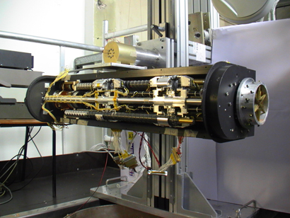
Large drill in horizontal position.

The rover’s drill in a clean room on Earth, in the stowed position. The drill will be able to penetrate down to two meters (six feet) into the subsurface. Image via ESA.

According to Jorge Vago, ESA’s ExoMars rover project scientist:

Our rover has really taken shape. We have an incredibly powerful scientific payload to explore the surface and subsurface of Mars on our quest to find biosignatures.

ExoMars will be an exciting mission, and along with NASA’s upcoming 2020 rover, the first since the Viking mission in the 1970s/1980s to look directly for evidence of life. The rover is expected to launch sometime between July 26 and August 13, 2020 on a Russian Proton-M launcher, arriving at Mars in March 2021.

More information about ExoMars mission is available on the mission website.

Bottom line: New 3-D models of the Martian terrain will help the Rosalind Franklin rover search for life on Mars in 2021.

Via Europlanet Society


from EarthSky https://ift.tt/2mSn9cO
Elevation lines on map.

Here’s a piece of one of the new 3-D models just created to help ESA’s Rosalind Franklin rover explore Mars in 2021. The models are so detailed that they show, for example, as dune ripples inside craters, as you see here. Image via TU Dortmund/ NASA/ JPL-Caltech/ Europlanet.

How do modern-day space explorers prepare to search an unknown terrain? Never mind that the explorers are robots, and that the preparers are space scientists and engineers. Next summer, an ambitious new mission to Mars is scheduled to launch. The ExoMars mission of the European Space Agency (ESA) will carry the robotic Rosalind Franklin rover to Mars. The rover will search for evidence of past Martian life in Oxia Planum, a large plain rich in clays and containing an old river delta. How do they prepare? A team of scientists at TU Dortmund University in Germany has created extremely detailed 3-D models of the landing location. These scientists said on September 16, 2019 that they want to use the models to understand the geography and geological characteristics of this unexplored region on Mars, and to help plan the path of the rover.

The 3-D models are called Digital Terrain Models (DTMs). They’re a variation of Digital Elevation Models (DEMs) used by space scientists to understand planets, moons and asteroids. These particular maps have a resolution of about 25 centimeters per pixel. One of scientists, Kay Wohlfarth, presented them at last week’s international meeting of astronomers in Geneva, Switzerland.

So how were the models created?

Colored elevation map.

One of the test 3-D models of terrain on Mars. Image via TU Dortmund/NASA/JPL-Caltech/Europlanet Society.

Colorful elevation map.

Another test 3-D models of terrain on Mars. Image via TU Dortmund/NASA/JPL-Caltech/Europlanet Society.

First, they use high-resolution imagery of Mars’ surface from the HiRISE camera on NASA’s Mars Reconnaissance Orbiter (MRO). That imagery is then applied to the classic stereo method of combining two images taken from slightly different angles, in order to create a 3D image of the landscape. But those kinds of stereo techniques can be limited when it comes to dusty and sandy surfaces – basically featureless – in locations like the Rosalind Franklin landing site, Oxia Planum. By necessity, the landing site is relatively flat to help ensure a safe landing.

The DTMs were then further enhanced by using a technique called Shape from Shading in which the intensity of reflected light in the image is translated into information on surface slopes. The slope data is combined with the stereo imagery, providing a much better estimate of the 3-D surface, while achieving the best resolution possible in the reconstructed landscape.

The resulting models give the scientists a much more detailed view of the landing region. As Wohlfarth explained:

With the technique, even small-scale details such as dune ripples inside craters and rough bedrock can be reproduced.

Rover on Mars.

Artist’s illustration of the Rosalind Franklin rover on Mars, part of ESA’s ExoMars mission. Image via ESA/ATG medialab.

Marcel Hess, first author of the study, said:

We have taken special care over the interaction between light and the Martian surface. Areas that are tilted towards the sun appear brighter and areas that are facing away appear darker. Our approach uses a joint reflectance and atmospheric model that incorporates reflection by the surface as well as atmospheric effects that diffuse and scatter light.

These new models will be a great aid to the rover as it navigates the landscape, looking for the best places to study with its array of instruments. Not only will the rover examine rocks and soil, it will also be able to drill up to two meters (six feet) into the subsurface, searching for possible biosignatures, chemical traces of past life. Samples will be delivered to the on-board laboratory for analysis.

PanCam, with its stereo and high-resolution cameras, will provide detailed views of interesting features in both visible and near-infrared wavelengths. Spectrometers will determine what rocks are composed of, and how much they were affected by water.

Large drill in horizontal position.

The rover’s drill in a clean room on Earth, in the stowed position. The drill will be able to penetrate down to two meters (six feet) into the subsurface. Image via ESA.

According to Jorge Vago, ESA’s ExoMars rover project scientist:

Our rover has really taken shape. We have an incredibly powerful scientific payload to explore the surface and subsurface of Mars on our quest to find biosignatures.

ExoMars will be an exciting mission, and along with NASA’s upcoming 2020 rover, the first since the Viking mission in the 1970s/1980s to look directly for evidence of life. The rover is expected to launch sometime between July 26 and August 13, 2020 on a Russian Proton-M launcher, arriving at Mars in March 2021.

More information about ExoMars mission is available on the mission website.

Bottom line: New 3-D models of the Martian terrain will help the Rosalind Franklin rover search for life on Mars in 2021.

Via Europlanet Society


from EarthSky https://ift.tt/2mSn9cO
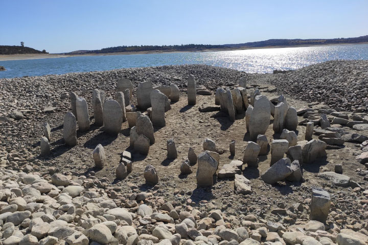
Drought reveals a lost Spanish Stonehenge

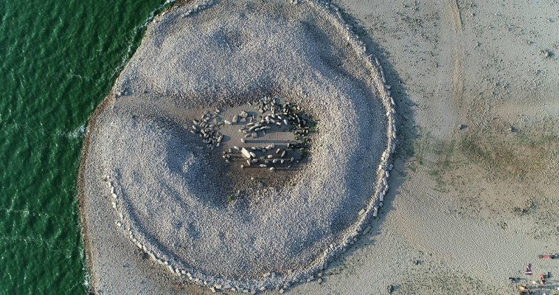
This image shows the remains of the standing stones in July 28, 2019, after having been submerged since the 1960s. Image via NASA Earth Observatory.

After 50 years underwater, Spain’s Dolmen of Guadalperal — a 7,000-year-old circle of 150 upright stones — is back on dry land, thanks to record heat and drought in Europe this summer.

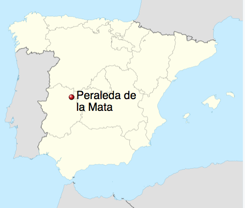
The megalithic monuments – known as the Spanish Stonehenge, located located in the town Peraleda de la Mata – have been underwater since the 1963 construction of the Valdecañas Dam flooded this region of western Spain. In the summer of 2019, several areas of Europe experienced drought conditions, including Spain, which had its third-driest June of the century, along with above-average temperatures in July and August. The drought conditions were enough to expose the Dolmen of Guadalperal, so that some residents of the nearby town of Peraleda de la Mata were able to see it for the first time. Angel Castaño is president of Raíces de Peralêda, a local cultural association dedicated to preserving the monument. He told AtlasObscura.com:

All my life, people had told me about the dolmen. I had seen parts of it peeking out from the water before, but this is the first time I’ve seen it in full. It’s spectacular because you can appreciate the entire complex for the first time in decades.

When we saw it, we were completely thrilled. It felt like we had discovered a megalithic monument ourselves.

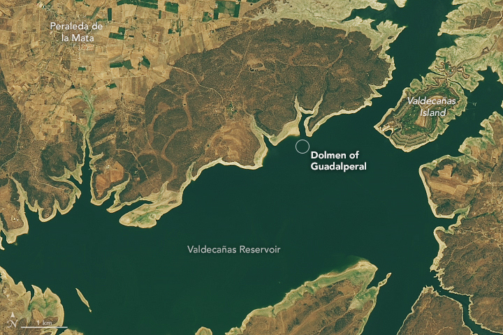
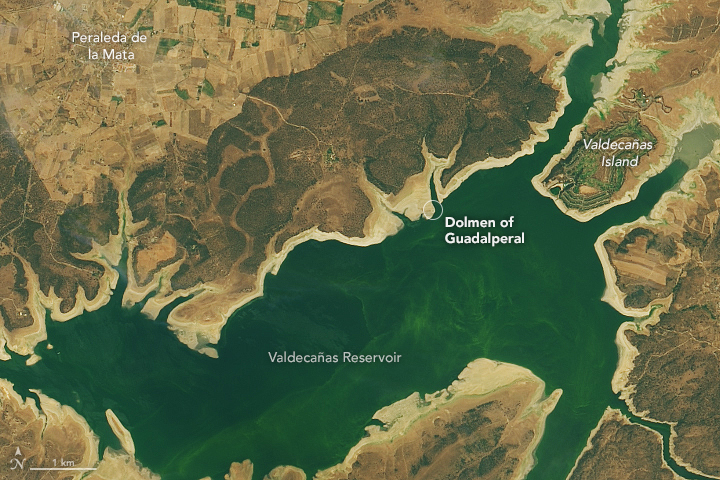
NASA Earth Observatory also reported on the reappearance of the Dolmen of Guadalperal, showing two different satellite images of it, captured in July 2013 and July 2019, by NASA’s Landsat 8 satellite. Note the changing water levels and the widening of the tan ring around the along the reservoir’s shoreline in the second image. These lighter colored sediments are the recently exposed lake bottom. A circle marks Dolmen of Guadalperal:

July 24, 2013. Image via Lauren Dauphin/NASA/USGS.

July 25, 2019. Image via Lauren Dauphin/NASA/USGS.

The Dolmen of Guadalperal was found in 1926, part of a research and excavation campaign led by the German archaeologist Hugo Obermaier between 1925 and 1927. Scientists believe it could have been a solar temple, as well as a burial enclave. Roman remains have been found there including a coin, ceramic fragments and a grinding stone. Axes, ceramics, flint knives and a copper punch were found in a nearby dump. According to the Spanish media outlet Repelando, a settlement was also found nearby, thought to date back to the time of the monument’s construction. There were homes, charcoal and ash stains, lots of pottery, mills and stones to sharpen axes among other objects, .

Since the 1960s, tips of the tallest megaliths have peaked out of the lake as water levels fluctuated. It consists of 150 granite stones or orthostates, placed in vertical arrangement that make up a chamber about 15 feet (five meters) in diameter preceded by an access corridor about 70 feet (21 meters) long.

At the end of the hall, just at the entrance of the chamber, there is a menhir or standing stone about 6 feet (2 meters) high that contains the image of a snake. Research suggests this image the Tagus River – longest river in the Iberian peninsula – which passes through the area.

The Dolmen of Guadalperal are located in the town of Peraleda de la Mata in Spain.

According to NASA’s Earth Observatory:

Archeologists believe the Dolmen of Guadalperal was originally constructed as an enclosed space — a large stone house with a cap. The dolmen could have served as a tomb, a site for religious rituals, or a trading hub since it was relatively easy to cross the river at this location.

The most recent recorded exploration and excavation of the site was by German archaeologist Hugo Obermaier in the 1920s. By the time Obermaier’s findings were published in the 1960s though, Valdecañas Reservoir was filled with water.

The Dolmen de Guadalperal was excavated and studied in the 1920s, drowned in the 1960s, and dry again in 2019. Image via 1080 Wildlife Productions/ AtlasObscura.

Bottom line: The Dolmen of Guadalperal – aka the Spanish Stonehenge, submerged for 50 years – is back on dry land, thanks to the hot and dry 2019 summer.

Via NASA Earth Observatory


from EarthSky https://ift.tt/2lVWAmZ

Meet Alpha Cephei, a rapidly rotating star

Alpha Cephei, or Alderamin, via M. Zao.

Astronomers used the CHARA array at Georgia State University – optical interferometer – to learn the inclination, polar and equatorial radius and temperature, as well as the rotation speed of Alpha Cephei. Read about this work here. Image via M. Zao.

The constellation Cepheus the King is not terribly conspicuous and can boast of only one relatively star. That star is Alderamin – aka Alpha Cephei – which is by far the brightest star in Cepheus, lighting up one corner of an otherwise faint house-shaped pattern of stars. While not one of the most conspicuous stars in the night sky, this star is easy to spot, and it is interesting for its rapid rotation on its axis.

Science of Alpha Cephei. Alderamin is a white star; it’s considered a Class A star, which is now evolving off of the main sequence into a subgiant. It’s thought that this star is now on its way to becoming a red giant as its internal supply of hydrogen fuel runs low.

According to the star expert Jim Kaler, Alderamin shines with the luminosity of 18 suns.

Alpha Cephei rotates rapidly. It completes one revolution in less than 12 hours, in contrast to nearly a month for our sun to turn on its axis. Jim Kaler writes of this star:

The spin may also be related to the star’s activity. [Our] sun is magnetically active in broad part because its outer third is churning up and down in huge convective currents, the movement helping to generate a magnetic field. Such outer zones are supposed to disappear in class A stars like Alderamin. Yet Alderamin emits about the same amount of X-ray radiation as does the sun and has other features that together suggest considerable magnetic activity. No one really knows why. Such anomalies, of course, drive the science. Understanding Alderamin will someday help us understand our own star, on which we depend for life.

By the way, Alpha Cephei is not a very powerful star in contrast to Cepheus’ two king-sized stars: Mu Cephei (the Garnet Star) and VV (two V’s) Cephei. Mu Cephei and VV Cephei are supergiants – among the largest and brightest in our Milky Way galaxy – shining with the firepower of hundreds of thousands of suns. If either star were to replace the sun in our solar system, its diameter would extend beyond the orbit of the planet Jupiter, which lies a good five times farther out from our sun than Earth does. Although both of these stars appear faint, only visible to the unaided eye on a dark, moonless night, it’s because they’re so distant, residing a few thousand light-years away.

Meanwhile, Alderamin is only 49 light-years away.

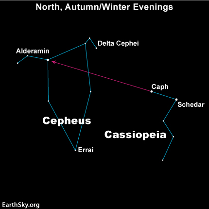
View larger. The constellation Cepheus the King has the shape of the house we all drew as children. Alderamin is by far the brightest star in this constellation.

View larger. The constellation Cepheus the King has the shape of the house we all drew as children. Alderamin, or Alpha Cephei, is by far the brightest star in this constellation. A line drawn between Schedar and Caph in the constellation Cassiopeia will lead you to Alpha Cephei.

How to find Alpha Cephei. On a dark night, Alpha Cephei is easily visible and also relatively easy to find. Look northward for this star. It is circumpolar throughout all of Europe, northern Asia, Canada and American cities as far south as San Diego. Its constellation, Cepheus, has the shape of the stick house we all drew as children. Cepheus is a rather faint constellation, but Alpha Cephei is by far its brightest star and is easily observable to the unaided eye, even in cities.

If you know the W or M-shaped constellation Cassiopeia the Queen, you can use the Cassiopeia stars Schedar and Caph to star-hop to Alderamin.

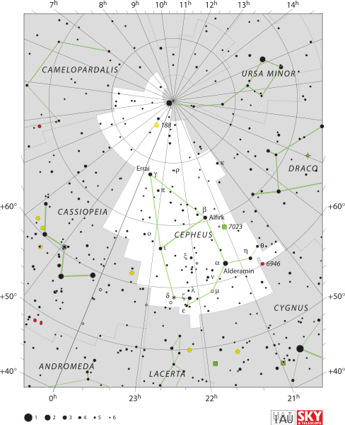
Sky chart of the constellation Cepheus the King

Sky chart of the constellation Cepheus the King

Alpha Cephei in the history of astronomy. Alpha Cephei has been a pole star in the past, that is, a star close to the sky’s north pole. The last time was in 18,000 BC. It will again be a pole star some 5,500 years from now. What kind of world will Earth be then? No matter. The heavens will pursue their long cycles, and Alpha Cephei will lie some three degrees from the sky’s north pole around the year 7500 CE. That means it won’t be as good a pole star as our present-day Polaris, which will be 0.4525 degrees from the north celestial pole in on March 24, 2100. But it’ll be pretty good.

This star’s proper name, Alderamin, is from the Arabic and means “the right arm,” presumably of Cepheus the King, who played a role in Greek mythology.

Bottom line: Cepheus the King is not a very conspicuous constellation and has only one relatively bright star, Alderamin – aka Alpha Cephei. This star is interesting for its rapid rotation on its axis.


from EarthSky https://ift.tt/2mNU2HN

Hazy light pyramid in east? False dawn

For the Northern Hemisphere, these next months are your best time all year to catch the zodiacal light, or “false dawn.” And the next few days are great, because the moon will be in a waning crescent. There might be some great photo opportunities with a waning crescent moon and the zodiacal light, since both will be located in the east before dawn breaks. On September 28, the moon will be new, or between the Earth and sun, and then it’ll be back entirely in the evening sky … gone from the sky before dawn, leaving it dark for your zodiacal light viewing pleasure.

Southern Hemisphere? Watch for the zodiacal light in the west, beginning about an hour after the sun goes down.

From temperate latitudes in either hemisphere, the zodiacal light is most easily seen around the time of the equinoxes. The morning zodiacal light prevails around the the time of the autumn equinox (now for the Northern Hemisphere, March-April for the Southern Hemisphere), and the evening zodiacal light around the time of the spring equinox (now for the Southern Hemisphere).

This light can be noticeable and easy to see from latitudes relatively close to Earth’s equator, for example, like those in the southern U.S. I’ve seen it many times from the latitude of southern Texas, sometimes while driving a lonely highway far from city lights, in the hour or so before true dawn begins to light the sky. In this case, the zodiacal light can resemble the lights of a city or town just over the horizon.

Meanwhile, skywatchers in the northern U.S. or Canada sometimes say, wistfully, that they’ve never seen it, although in recent years we’ve seen many photographs of the zodiacal light taken from those northerly latitudes.

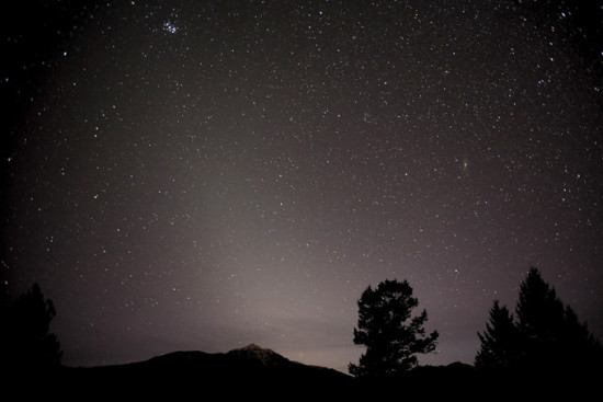
Here's the zodiacal light as captured on film in Canada. This wonderful capture is from Robert Ede in Invermere, British Columbia.

Here’s the zodiacal light as captured on film in Canada. This wonderful capture is from Robert Ede in Invermere, British Columbia.

zodiacal light

.

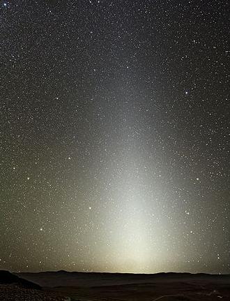
You need a dark sky location to see the zodiacal light, someplace where city lights aren’t obscuring the natural lights in the sky. The zodiacal light is a pyramid-shaped glow in the east before dawn (or after twilight ends in the evening, if you’re in the Southern Hemisphere now). It’s even “milkier” in appearance than the starlit trail of the summer Milky Way.

It’s most visible before dawn at this time of year because, as seen from the Northern Hemisphere, because the ecliptic – or path of the sun, moon and planets – stands nearly straight up with respect to the eastern horizon before dawn now. As seen from the Southern Hemisphere, the same is true of the western horizon after true darkness falls.

The zodiacal light can be seen for up to an hour before true dawn begins to break. Look for it about 120 to 80 minutes before sunrise. Unlike true dawn, though, there’s no rosy color to the zodiacal light. The reddish skies at dawn and dusk are caused by Earth’s atmosphere, and the zodiacal light originates far outside our atmosphere.

When you see the zodiacal light, you are looking edgewise into our own solar system. The zodiacal light is actually sunlight reflecting off dust particles that move in the same plane as Earth and the other planets orbiting our sun.

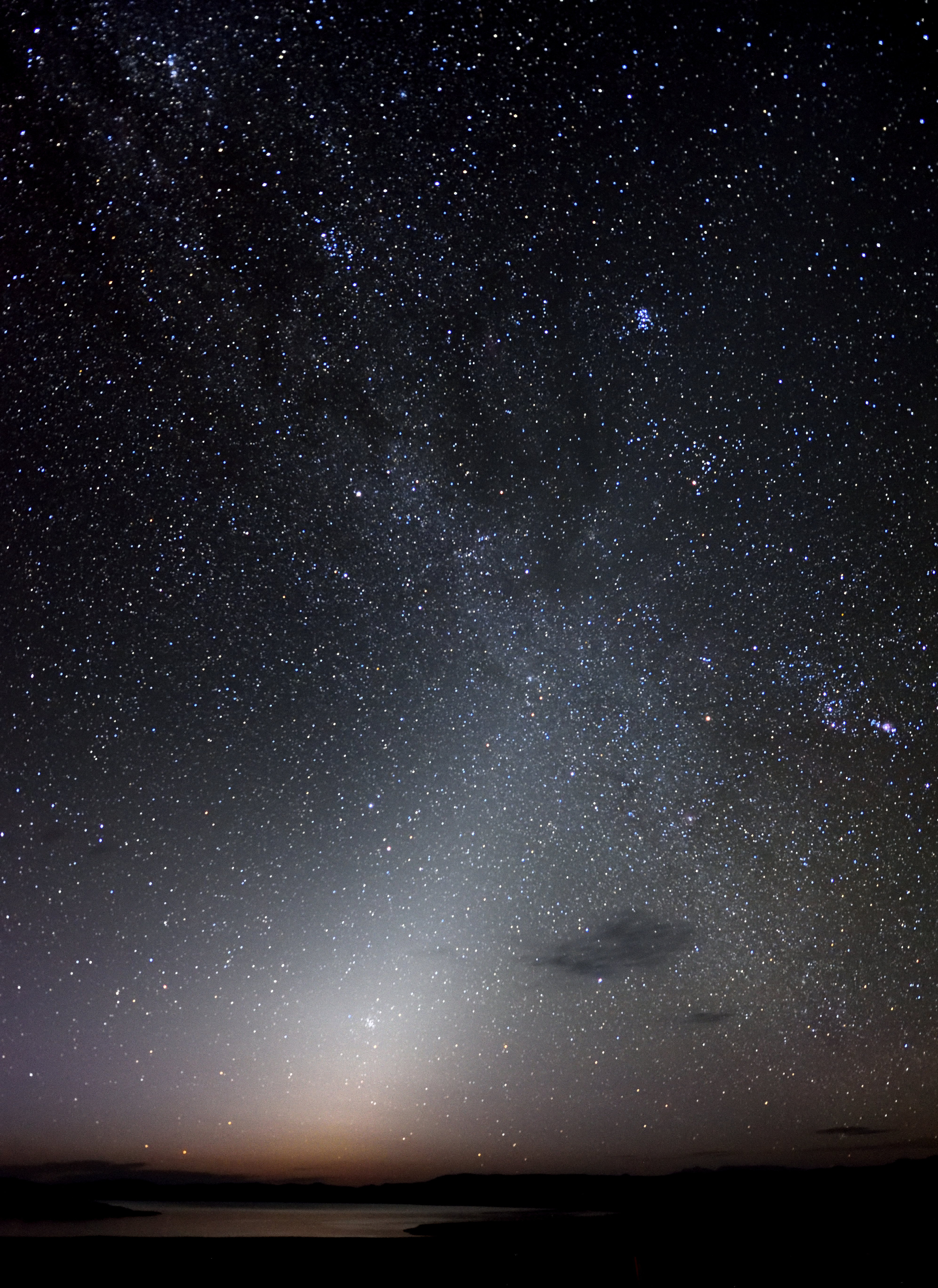
Zodiacal light on the morning of August 31, 2017, with Venus in its midst, captured at Mono Lake in California. Eric Barnett wrote: “I woke from sleeping in the car thinking sunrise was coming. My photographer friend, Paul Rutigliano, said it was the zodiacal light. I jumped up, got my camera into position and captured about a dozen or so shots.”

Bottom line: The September equinox happened a few days ago. No matter where you are on Earth, your local autumn is the best time to see the zodiacal light before dawn. Your local spring is the best time to see it in the evening.

An almanac can help you find the clock time for sunrise in your sky

Everything you need to know: zodiacal light or false dawn

Donate: Your support means the world to us


from EarthSky https://ift.tt/2lerJBF

Different challenges, same determination: how we’re tackling children’s and young people’s cancers.

Image of a children's cancer researcher.

Every year, around 4,500 children and young people up to the age of 24 are diagnosed with cancer in the UK. And thanks to research, around 8 in 10 of those diagnosed today will survive for at least 5 years.

It’s a big improvement in survival. But it’s not the full picture.

“The 8 in 10 statistic is an average,” says Dr Sheona Scales, who looks after children’s and young people’s research at Cancer Research UK. “It doesn’t show the disparity in survival between cancer types. And it doesn’t reflect anything about quality of life after treatment.”

Survival rates for some children’s cancers haven’t improved much since the 1970s.  And of the children and young people who do survive their cancer, some experience serious, long-term side effects from their treatment, which can affect them for the rest of their lives.

We want to change this. Our aim is to improve survival across the board and reduce long-term side effects. And we’ve got a newly refreshed research strategy to help us get there.

Your challenge, should you choose to accept it…

Cancer in children and young people is different to cancer in adults – from the types of cancer and the impact of treatment, to the specific challenges facing the research community.

Dr Susanne Gatz is a children's cancer researcher in Birmingham

Dr Susanne Gatz is a children’s cancer researcher in Birmingham.

Someone who knows this all too well is Dr Susanne Gatz, a children’s cancer doctor and researcher at the Cancer Research UK Clinical Trials Unit at the University of Birmingham.

“There are lots of different types of cancer that children and young people can be diagnosed with, including ones that are unique to this age group,” she explains. This includes cancers like retinoblastoma and neuroblastoma.

“This, coupled with the fact that cancer is rare in children and young people can make these cancers difficult to research.” Gatz says that for people working in the area, there’s an incredible requirement to not only have a good depth but also breadth of knowledge. This includes knowing what’s needed in the clinic to help patients, but also what research is necessary and possible to achieve this.

“It also means we have to put in an enormous collaborative effort across borders in order to carry out research and clinical trials.”

Which can be tricky when there aren’t enough people researching children’s and young people’s cancers.

Scales, who led the development and implementation of our new research strategy, believes that the relatively high survival figures could be one reason more scientists aren’t choosing to research children and young people’s cancers.

“It clouds their perception of the fact that there’s still an urgency to improve our understanding of children’s and young people’s cancers, and to find new treatments with fewer long-term side effects,” she adds.

Whatever the reason, Gatz believes the community needs a boost. “We need more people who want to work in this area, who are then in turn supported enough to do so,” she explains. This includes help bridging the gap between researchers at the bench and the doctors who treat patients.

And she’s not the only one. To help develop our new strategy, we spoke to scientists in the UK and around the world to try and understand the challenges they face.

Our hope is that by allowing the community to share ideas and knowledge more easily, we’ll drive progress in this area

Dr Sheona Scales, paediatric lead at Cancer Research UK

What we heard from them echoed Gatz.

They told us that in order to make progress, there needs to be more researchers and better support, as well as access to large, structured collaborations with other scientists, including those who don’t work in children’s cancer research.

But the collaboration doesn’t stop there. Gatz says there needs to be a shift in thinking about how scientists can work more closely together with the pharmaceutical industry.

“We need industry to do things not because they have to, but because they want to, because we’ve shown them there’s a need in this area.”

Challenge accepted: our new strategy

“We’ve been hearing more and more from the research and parent communities that progress isn’t happening fast enough in this area,” explains Scales. That’s what we’re aiming to change, by tackling some of the key challenges outlined by Gatz and others.

Our refreshed approach, which builds on the work we’ve already done in children’s and young people’s cancers, has been developed in partnership with scientists, doctors, young people who’ve survived cancer and parents whose child was diagnosed with cancer.

“We want to support the children’s and young people’s cancer research community to be more joined up and collaborative,” says Scales.

Scales says we’ll begin by hosting workshops to encourage and facilitate collaboration between doctors and lab-based scientists and between cancer researchers and researchers from other fields.

“And excitingly, we’ve already begun work to establish a virtual children and young people’s cancer research network across the UK,” she adds. “Our hope is that by allowing the community to share ideas and knowledge more easily, we’ll drive progress in this area.”

It’s something that Gatz also believes is important for driving progress. “We are already sharing data, but we need to build on this to make it even more effective,” she adds.

And we’re not stopping there. To help boost funding, we launched the Cancer Research UK for Children & Young People’s Cancer Innovation Award. It’s open to researchers with an interest in helping more children and young people survive cancer, especially those who don’t usually work in this field.

“Although our research spend on children’s and young people’s cancers has gone up year-on-year, this hasn’t been by as much as we’d like,” says Scales. “We hope that funding calls like this will attract more researchers to the area, and that in the future, we can fund more high-quality research.”

We’re also exploring how we can encourage relationships between academic researchers and the pharmaceutical industry, to help drive development of new and better drugs for children’s and young people’s cancers.

Scales hopes that our refreshed strategy will demonstrate our renewed commitment to children’s and young people’s cancers. “We want to be part of this momentum for change, not just now, but for the long-term.”

A new hope

Clara Markiewicz was diagnosed with cancer when she was 4.

Clara Markiewicz was diagnosed with cancer when she was 4.

“I’m so excited about this strategy,” says Clara Markiewicz, a 22-year-old a soon-to-be-qualified children’s nurse who was diagnosed with cancer when she was 4.

“Today, I’m able to live my life without this fact overshadowing anything. But this still isn’t the case for many children and young people and there is still so much to be done.”

She says the strategy highlights the work that’s still needed to improve survival for children and young people with cancer. And to ensure their futures are impacted as minimally as possible by having had cancer.

“But it also offers hope to those affected that they can make it through their devastating diagnosis and go on to lead full, healthy lives.”

Lauren Griffiths is a brand executive for children’s cancers


from Cancer Research UK – Science blog https://ift.tt/2lIzJen

Was Venus ever habitable?

Blue ball with orange-brown splotches, against a black background.

Artist’s concept of an ancient planet Venus, with a shallow ocean. Image via NASA.

The second planet outward from our sun – Venus, named for the Roman goddess of love – is Earth’s near-twin in size and density. But it’s a hellish place, with dense clouds of carbon dioxide laced with sulfuric acid. Its surface pressure is 90 times that of Earth, and its surface temperatures are hot enough to melt lead. Yet – at last week’s international meeting of astronomers in Geneva, Switzerland, Michael Way of NASA presented a very different view of Venus. He said on September 20, 2019 that new research reveals Venus may once have been a temperate world, more like Earth, with a shallow ocean of liquid water on its surface for some 2 to 3 billion years. The new research suggests that, only around 700 million years ago, a dramatic transformation began for Venus, ultimately resurfacing some 80% of our sister world. These scientists said in a statement that their study:

… gives a new view of Venus’s climatic history and may have implications for the habitability of exoplanets in similar orbits.

This isn’t the first time scientists have contemplated liquid water on Venus. NASA’s Pioneer-Venus mission – which visited the planet 40 years ago – found tantalizing hints of long-gone shallow ocean. To see if Venus might ever have had a stable climate capable of supporting liquid water, Way and his colleague, Anthony Del Genio, created five different computer simulations of Venus in the past. Each assumed a different level of water coverage. In all five scenarios, these scientists found that Venus was able to maintain stable temperatures between a maximum of about 122 degrees Fahrenheit (50 degrees C) and a minimum of about 68 degrees F (20 degrees C) for around three billion years.

Hotter than Earth, yes, but a far cry from the average temperature of 865°F (462 degrees C) on Venus today. If one of these scenarios describes something akin to Venus in the past, what happened to change things?

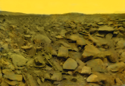
Spacecraft image of a lifeless, dry, rocky planetary surface, under a yellow sky.

This modified image is based on the 1st-ever image from the surface of Venus, returned by the Soviet Venera 9 spacecraft in 1975. Looks harsh, doesn’t it? Image via Venera 9 and Ted Styrk’s blog. Read more about this image from the Planetary Society.

According to these scientists, Venus might have maintained its temperate climate until today, if not for a series of events that caused a release, or ‘outgassing’, of carbon dioxide stored in the rocks of the planet approximately 700 to 750 million years ago.

As we all should know by now, carbon dioxide is a greenhouse gas: it traps heat.

The cause of this outgassing is a mystery, these scientists said, but it might be linked to volcanic activity on Venus:

One possibility is that large amounts of magma bubbled up, releasing carbon dioxide from molten rocks into the atmosphere. The magma solidified before reaching the surface and this created a barrier that meant that the gas could not be reabsorbed. The presence of large amounts of carbon dioxide triggered a runaway greenhouse effect, which has resulted in the scorching 462-degree average temperatures found on Venus today.

Did it happen? Was Venus more temperate in the past? We don’t know. Computer simulations such as these serve to show not what did happen, but what could happen. The scientists acknowledged “two major unknowns:”

The first relates to how quickly Venus cooled initially and whether it was able to condense liquid water on its surface in the first place. The second unknown is whether the global resurfacing event was a single event or simply the latest in a series of events going back billions of years in Venus’s history.

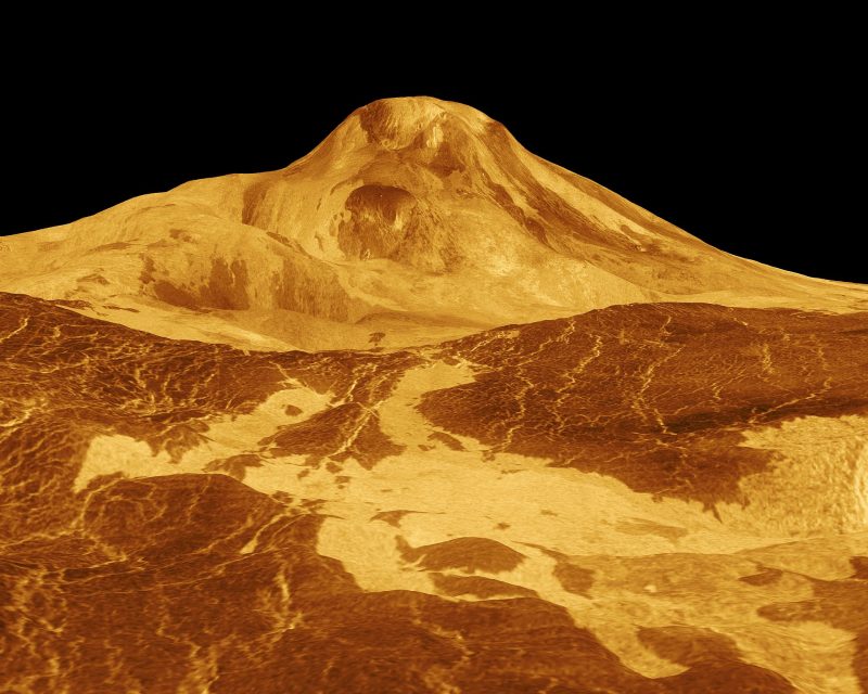
Orange-colored image of large shield volcano, with visible lava flows, against a black sky.

Although we haven’t found an active volcano on Venus yet, we know Venus has volcanic features and that volcanos have been active there recently, in geologic terms, within the last several million years. In fact, as of now, Venus is known to have more volcanoes than any other planet in our solar system: over 1,600 major volcanoes. Here is Maat Mons on Venus, the highest volcano on Venus, 5-miles (8-km-) high. This perspective view is based on Magellan radar images. Read more via NASA PhotoJournal.

Way and his team also acknowledged in their statement that many researchers believe that Venus is beyond the inner boundary of our solar system’s habitable zone; it’s been suggested, in other words, that Venus is too close to the sun to support liquid water. But the new study suggests otherwise. Way said:

Venus currently has almost twice the solar radiation that we have at Earth. However, in all the scenarios we have modelled, we have found that Venus could still support surface temperatures amenable for liquid water.

This finding, if supported by other scientific work, may have implications for our understanding of exoplanets orbiting in distant solar systems. You’ve heard of the Goldilocks zone, or habitable zone? It’s the zone around a star in which orbiting planets are capable of supporting liquid water on their surfaces. Not too hot, not too cold, in other words. Maybe we don’t understand the true boundary of the habitable zone, either in the direction toward a solar system’s central star, or in the other direction, or in both directions. Maybe our understanding of habitables zones needs a tweak.

Of course, these scientists said, as scientists nearly always say upon the completion of any study, that more studies are needed. Way said:

We need more missions to study Venus and get a more detailed understanding of its history and evolution.

However, our models show that there is a real possibility that Venus could have been habitable and radically different from the Venus we see today. This opens up all kinds of implications for exoplanets found in what is called the ‘Venus Zone’, which may in fact host liquid water and temperate climates.

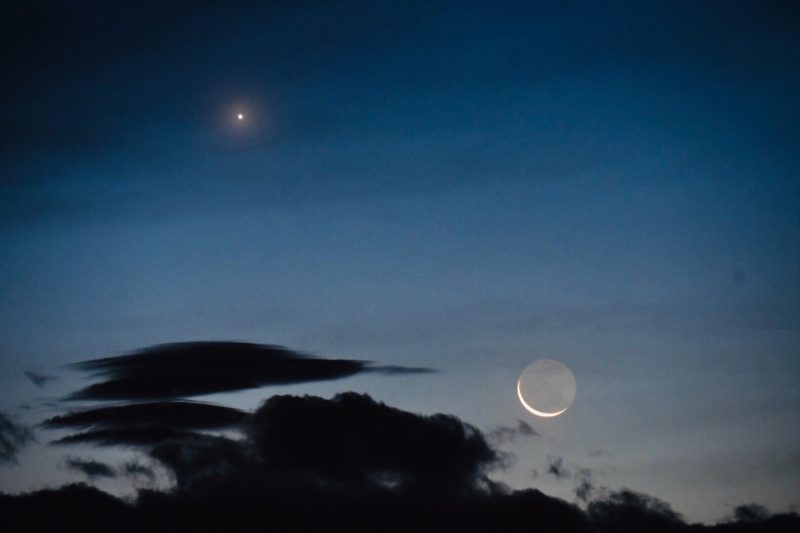
Bright Venus in the twilight with an exceedingly thin and fragile waning moon below it.

Venus is the brightest planet visible in Earth’s sky. Only the moon outshines it at night. Our friend Jenney Disimon caught the moon and Venus on June 2, 2019, from Kota Kinabalu, Sabah, N. Borneo. The extreme brightness for Venus stems in part from its highly reflective clouds, which trap heat near the planet, elevating temperatures. Read more about when we might see Venus in our sky again in EarthSky’s monthly planet guide.

Bottom line: Venus is a hellish world today. Did it ever have a stable climate or liquid water? To learn more, scientists created a series of 5 simulations assuming different levels of water coverage. In all 5 models, Venus maintained relativity moderate temperatures for around 3 billion years.

Via Europlanet Society


from EarthSky https://ift.tt/2mBADcO

Why we need to get back to Venus

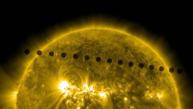
On June 5-6, 2012, NASA’s Solar Dynamics Observatory collected images of one of the rarest predictable solar events: the transit of Venus across the face of the sun. Image via NASA/SDO, AIA

By Paul K. Byrne, North Carolina State University

Just next door, cosmologically speaking, is a planet almost exactly like Earth. It’s about the same size, is made of about the same stuff and formed around the same star.

To an alien astronomer light years away, observing the solar system through a telescope, it would be virtually indistinguishable from our own planet. But to know the surface conditions of Venus – the temperature of a self-cleaning oven, and an atmosphere saturated with carbon dioxide with sulfuric acid clouds – is to know that it’s anything but Earth-like.

So how is it that two planets so similar in position, formation and composition can end up so different? That’s a question that preoccupies an ever-growing number of planetary scientists, and motivates numerous proposed Venus exploration efforts. If scientists can understand why Venus turned out the way it did, we’ll have a better understanding of whether an Earth-like planet is the rule – or the exception.

I’m a planetary scientist, and I’m fascinated by how other worlds came to be. I’m particularly interested in Venus, because it offers us a glimpse of a world that once might not have been so different from our own.

Two images of a flat, gray, rocky landscape.

The surface of Venus as seen in these reprocessed perspective image panoramas from the Soviet Venera 13 lander. Image via Don P. Mitchell

A once-blue Venus?

The current scientific view of Venus holds that, at some point in the past, the planet had much more water than its bone-dry atmosphere suggests today – perhaps even oceans. But as the sun grew hotter and brighter (a natural consequence of aging), surface temperatures rose on Venus, eventually vaporizing any oceans and seas.

With ever more water vapor in the atmosphere, the planet entered a runaway greenhouse condition from which it couldn’t recover. Whether Earth-style plate tectonics (where the outer layer of the planet is broken into large, mobile pieces) ever operated on Venus is unknown. Water is critical for plate tectonics to operate, and a runaway greenhouse effect would effectively shut down that process had it operated there.

But the ending of plate tectonics wouldn’t have spelled the end of geological activity: The planet’s considerable internal heat continued to produce magma, which poured out as voluminous lava flows and resurfaced most of the planet. Indeed, the average surface age of Venus is around 700 million years – very old, certainly, but much younger than the multi-billion-year-old surfaces of Mars, Mercury or the moon.

Blue ball with white swirls

An artist’s impression of what a formerly water-rich Venus may have looked like. Image via Daein Ballard

The exploration of Planet 2

The Venus-as-a-wet-world view is just a hypothesis: Planetary scientists don’t know what caused Venus to differ so much from Earth, nor even if the two planets really did start off with the same conditions. Humans know less about Venus than we do about the other inner solar system planets, largely because the planet poses several unique challenges to its exploration.

For example, radar is needed to pierce the opaque, sulfuric acid clouds and see the surface. That’s a lot trickier than the readily visible surfaces of the Moon or Mercury. And the high surface temperature – 470 degrees Celsius (880 degrees Fahrenheit) – means that conventional electronics don’t last more than a few hours. That’s a far cry from Mars, where rovers can operate for more than a decade. In part because of the heat, acidity and obscured surface, then, Venus hasn’t enjoyed a sustained program of exploration over the past couple of decades.

Mottled orange ball.

Visible-wavelength light is unable to penetrate the thick cloud layer on Venus. Instead, radar is required to view the surface from space. This is a global radar image mosaic of the planet, compiled with data returned by the Magellan mission. Image via SSV/MIPL/MAGELLAN TEAM/NASA

That said, there have been two dedicated Venus missions in the 21st century: the European Space Agency’s Venus Express, which operated from 2006 to 2014, and the Japan Aerospace Exploration Agency’s Akatsuki spacecraft currently in orbit .

Humans haven’t always ignored Venus. It was once the darling of planetary exploration: between the 1960s and 1980s, some 35 missions were dispatched to the second planet. The NASA Mariner 2 mission was the first spacecraft to successfully carry out a planetary encounter when it flew past Venus in 1962. The first images returned from the surface of another world were sent from the Soviet Venera 9 lander after it touched down in 1975. And the Venera 13 lander was the first spacecraft to return sounds from the surface of another world. But the last mission NASA launched to Venus was Magellan in 1989. That spacecraft imaged almost the entire surface with radar before its planned demise in the planet’s atmosphere in 1994.

The Magellan mission was launched from Atlantis’ cargo bay on May 4, 1982. The spacecraft’s high gain antenna is visible at the top of the image. Image via NASA.

Back to Venus?

In the last few years, several NASA Venus missions have been proposed. The most recent planetary mission that NASA chose is a nuclear-powered craft called Dragonfly, destined for Saturn’s moon Titan. However, one proposal to measure the composition of the Venus surface was selected for further technology development.

Other missions being considered include one by the ESA to map the surface at high resolution, and a Russian plan to build on its legacy as the only country to successfully put a lander on Venus’ surface.

Some 30 years after NASA set course for our hellish neighbor, the future of Venus exploration looks promising. But a single mission – a radar orbiter or even a long-lived lander – won’t solve all the outstanding mysteries.

Rather, a sustained program of exploration is needed to bring our knowledge of Venus to where we understand it as well as Mars or the moon. That will take time and money, but I believe it’s worth it. If we can understand why and when Venus came to be the way it is, we’ll have a better grasp of how an Earth-size world can evolve when it’s close to its star. And, under an ever-brightening sun, Venus may even help us understand the fate of Earth itself.

Paul K. Byrne, Assistant Professor of Planetary Geology, North Carolina State University

This article is republished from The Conversation under a Creative Commons license. Read the original article.

Bottom line: A planetary scientist explains why it’s important to explore planet Venus.

The Conversation


from EarthSky https://ift.tt/2l6fzuK