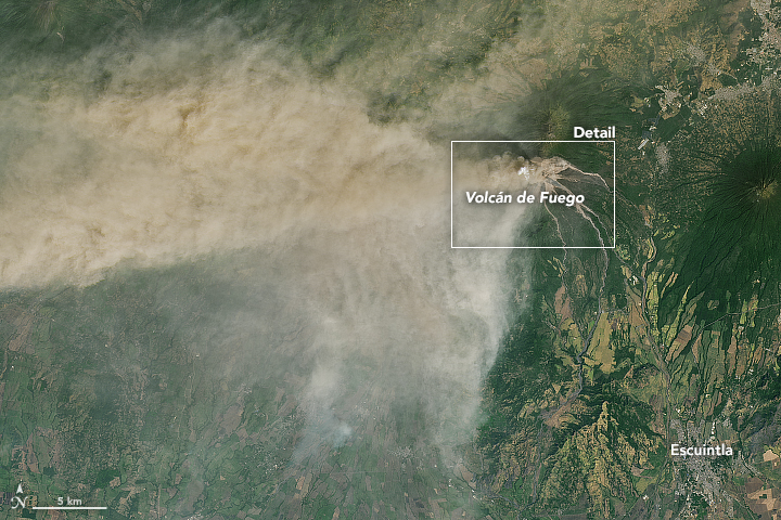
February 1, 2018, satellite image – in natural color – of a burst from Volcán de Fuego. Ash in a volcanic plume typically appears brown or gray in space images, while steam appears white. Image via Landsat 8 and NASA Earth Observatory.
Guatemala’s Volcán de Fuego began a new round of explosive activity on January 31, 2018. This volcano – located about 40 miles (70 km) west of Guatemala City – is known for its explosive activity, spreading ash plumes, and spectacular lava flows. This eruption was its first of 2018. It ended after about 20 hours of activity.
The Operational Land Imager (OLI) on Landsat 8 captured the natural-color image above of the eruption. Click here for a wider view.
Meanwhile, photographers on the ground were busy as well, taking in the dramatic show this volcano provides.

As the eruption of Volcán de Fuego progressed, lava poured down the slopes of the volcano. This view is from the municipality of Alotenango, Sacatepéquez, Guatemala, on February 1, 2018. Image via Esteban Biba (EFE)/ El País.
NASA said:
According to the Coordinadora Nacional para la Reducción de Desastres (CONRED), the plume reached an altitude of 21,300 feet (6,500 meters) above sea level and was carried 25 miles (40 km) to the west and southwest by the winds. Falling ash affected tens of thousands of people, primarily in the provinces of Escuintla and Chimaltenango. Lava from two active conduits flowed through four ravines, leading officials to preemptively close National Route 14 to vehicles.
In addition to ash, the plume contains gaseous components invisible to the human eye, including sulfur dioxide SO2. The gas can affect human health—irritating the nose and throat when breathed in—and reacts with water vapor to produce acid rain. It also can react in the atmosphere to form aerosol particles, which can contribute to outbreaks of haze and influence the climate.

This map shows concentrations of SO2 detected on February 1, 2018, by the Ozone Mapper Profiler Suite (OMPS) on the Suomi National Polar-orbiting Partnership (Suomi-NPP) satellite. Image via NASA Earth Observatory.
Another natural-color space view of the outburst of Volcán de Fuego on February 1, 2018. Image via Landsat 8 and NASA Earth Observatory.
Bottom line: Images of the first eruption of 2018 of Volcán de Fuego in Guatemala.
Read more from NASA Earth Observatory
from EarthSky http://ift.tt/2EfpAgz
February 1, 2018, satellite image – in natural color – of a burst from Volcán de Fuego. Ash in a volcanic plume typically appears brown or gray in space images, while steam appears white. Image via Landsat 8 and NASA Earth Observatory.
Guatemala’s Volcán de Fuego began a new round of explosive activity on January 31, 2018. This volcano – located about 40 miles (70 km) west of Guatemala City – is known for its explosive activity, spreading ash plumes, and spectacular lava flows. This eruption was its first of 2018. It ended after about 20 hours of activity.
The Operational Land Imager (OLI) on Landsat 8 captured the natural-color image above of the eruption. Click here for a wider view.
Meanwhile, photographers on the ground were busy as well, taking in the dramatic show this volcano provides.
As the eruption of Volcán de Fuego progressed, lava poured down the slopes of the volcano. This view is from the municipality of Alotenango, Sacatepéquez, Guatemala, on February 1, 2018. Image via Esteban Biba (EFE)/ El País.
NASA said:
According to the Coordinadora Nacional para la Reducción de Desastres (CONRED), the plume reached an altitude of 21,300 feet (6,500 meters) above sea level and was carried 25 miles (40 km) to the west and southwest by the winds. Falling ash affected tens of thousands of people, primarily in the provinces of Escuintla and Chimaltenango. Lava from two active conduits flowed through four ravines, leading officials to preemptively close National Route 14 to vehicles.
In addition to ash, the plume contains gaseous components invisible to the human eye, including sulfur dioxide SO2. The gas can affect human health—irritating the nose and throat when breathed in—and reacts with water vapor to produce acid rain. It also can react in the atmosphere to form aerosol particles, which can contribute to outbreaks of haze and influence the climate.
This map shows concentrations of SO2 detected on February 1, 2018, by the Ozone Mapper Profiler Suite (OMPS) on the Suomi National Polar-orbiting Partnership (Suomi-NPP) satellite. Image via NASA Earth Observatory.
Another natural-color space view of the outburst of Volcán de Fuego on February 1, 2018. Image via Landsat 8 and NASA Earth Observatory.
Bottom line: Images of the first eruption of 2018 of Volcán de Fuego in Guatemala.
Read more from NASA Earth Observatory
from EarthSky http://ift.tt/2EfpAgz