NASA Earth Observatory published this original article on July 10, 2024. Edits by EarthSky.
Extreme heat hammers U.S. coasts
In June 2024, early summer heat waves hit both the western and eastern United States. Temperatures in July have not brought much relief.
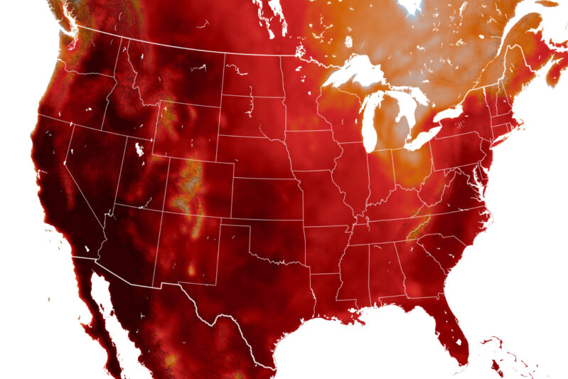
The map above shows how, in the West, there are many areas of intense heat west of the Rockies, from Mexico to Canada. According to the National Weather Service (NWS), temperatures commonly surged over 100 F (37.7 C) on July 10, causing widespread heat risk. On that same day, parts of the East – from South Carolina to Massachusetts – were under heat warnings or advisories. High humidity boosted the heat index to over 100 F in some places. The higher the heat index, which indicates how hot it feels when accounting for both temperature and relative humidity, the harder it is for the human body to cool itself.
In parts of the Midwest, cooler-than-average temperatures followed the northeastward path of Cyclone Beryl’s remnants. But in southeast Texas, temperatures on July 10 remained in the 90s. And heat indices climbed over 100 F (37.7 C). After Beryl swept ashore as a Category 1 hurricane on July 8, the lack of electrical power and air conditioning raised the risk for heat-related illnesses, according to NWS Houston.
A closer look at the U.S. Southwest
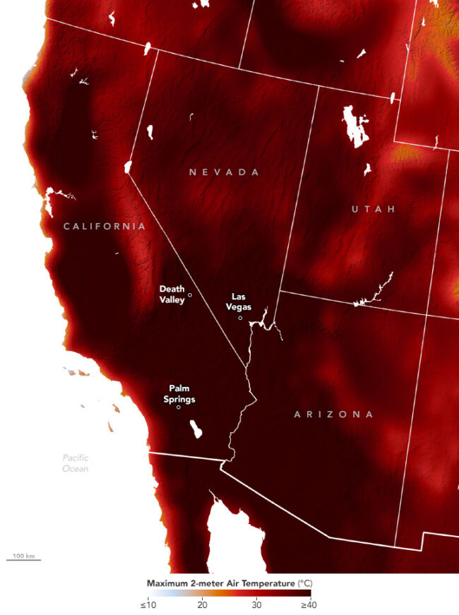
The map below shows a detailed view of the Southwest, where heat in early July has been especially intense. On July 10, Las Vegas saw its 5th consecutive day of temperatures of at least 115 F (46 C), according to NWS Las Vegas. Those temperatures hovered around the city’s previous all-time high of 117 F (47 C) but below the new all-time record of 120 F (49 C). That new record is from just a week ago, on July 7, 2024. Palm Springs, California, also hit an all-time high of 124 F on July 5. And Death Valley approached its record high when the temperature reached 129 F on July 7, according to The Washington Post.
Forecasters expect little relief from the long-lasting heat wave in the coming days, with dangerous temperatures in the West persisting through July 13 and the threat of extreme heat in the West increasing starting July 15.

Bottom line: Extreme heat has hammered the U.S. already this summer. Take a look at a map of the states and learn more about the heat on the East and West Coasts.
The post Map shows extreme heat hammering U.S. coasts first appeared on EarthSky.
from EarthSky https://ift.tt/hEid3ZD

NASA Earth Observatory published this original article on July 10, 2024. Edits by EarthSky.
Extreme heat hammers U.S. coasts
In June 2024, early summer heat waves hit both the western and eastern United States. Temperatures in July have not brought much relief.
The map above shows how, in the West, there are many areas of intense heat west of the Rockies, from Mexico to Canada. According to the National Weather Service (NWS), temperatures commonly surged over 100 F (37.7 C) on July 10, causing widespread heat risk. On that same day, parts of the East – from South Carolina to Massachusetts – were under heat warnings or advisories. High humidity boosted the heat index to over 100 F in some places. The higher the heat index, which indicates how hot it feels when accounting for both temperature and relative humidity, the harder it is for the human body to cool itself.
In parts of the Midwest, cooler-than-average temperatures followed the northeastward path of Cyclone Beryl’s remnants. But in southeast Texas, temperatures on July 10 remained in the 90s. And heat indices climbed over 100 F (37.7 C). After Beryl swept ashore as a Category 1 hurricane on July 8, the lack of electrical power and air conditioning raised the risk for heat-related illnesses, according to NWS Houston.
A closer look at the U.S. Southwest
The map below shows a detailed view of the Southwest, where heat in early July has been especially intense. On July 10, Las Vegas saw its 5th consecutive day of temperatures of at least 115 F (46 C), according to NWS Las Vegas. Those temperatures hovered around the city’s previous all-time high of 117 F (47 C) but below the new all-time record of 120 F (49 C). That new record is from just a week ago, on July 7, 2024. Palm Springs, California, also hit an all-time high of 124 F on July 5. And Death Valley approached its record high when the temperature reached 129 F on July 7, according to The Washington Post.
Forecasters expect little relief from the long-lasting heat wave in the coming days, with dangerous temperatures in the West persisting through July 13 and the threat of extreme heat in the West increasing starting July 15.

Bottom line: Extreme heat has hammered the U.S. already this summer. Take a look at a map of the states and learn more about the heat on the East and West Coasts.
The post Map shows extreme heat hammering U.S. coasts first appeared on EarthSky.
from EarthSky https://ift.tt/hEid3ZD

Aucun commentaire:
Enregistrer un commentaire