Hurricanes and global warming
Here’s another recent story about global warming and storms. A new study suggests that – by the late 21st century – hurricanes will linger longer over northeastern U.S. cities. According to this study, the storms can be expected to arrive more quickly, but slow down once they’ve made landfall. As storms linger longer over the U.S. East Coast, these scientists pointed out, they have the potential to cause greater damage along that heavily populated corridor.
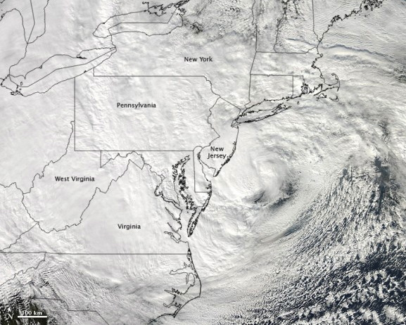
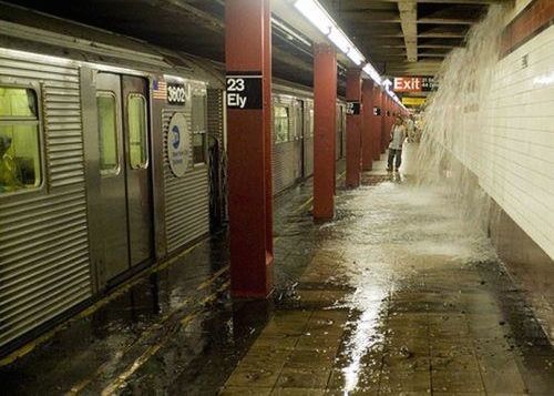
Maybe you recall what happened on October 29, 2012, when Hurricane Sandy made landfall in the U.S. Northeast. Unofficially known as Superstorm Sandy, it affected millions of people along the U.S. Mid-Atlantic and Northeast coasts. It was to be the deadliest and most destructive hurricane of the 2012 Atlantic hurricane season, as well as, at the time, the 2nd-costliest hurricane in United States history. It’s now been bumped down to 5th-most-costly, by the way. Sandy also killed hundreds of people in the U.S., Caribbean and Canada. One reason it hit so hard was that, once it made landfall, it lingered.
And now scientists are saying that lingering will be a trait of hurricanes in the U.S. Northeast by the end of this century. The transdisciplinary open-access journal Earth’s Future published the new study on November 22, 2021.
EarthSky 2022 lunar calendars now available! They make great gifts. Order now. Going fast!
35,000 computer-simulated storms
The American Geophysical Union (AGU) – largest U.S. organization of Earth scientists – said in a statement on November 22, 2021, that:
… In the new study, climate scientist Andra Garner at Rowan University (@AndraJReed on Twitter) analyzed more than 35,000 computer-simulated storms. To assess likely storm outcomes in the future, Garner and her collaborators compared where storms formed, how fast they moved and where they ended from the pre-industrial period [from about 1850-1900] through the end of the 21st century.
The researchers found that future East Coast hurricanes will likely cause greater damage than storms of the past. The research predicted that a greater number of future hurricanes will form near the East Coast, and those storms will reach the Northeast corridor more quickly. The simulated storms slow to a crawl as they approach the East Coast, allowing them to produce more wind, rain, floods, and related damage in the Northeast region. The longest-lived tropical storms are predicted to be twice as long as storms today …
The changes in storm speed will be driven by changes in atmospheric patterns over the Atlantic, prompted by warmer air temperatures. While Garner and her colleagues note that more research remains to be done to fully understand the relationship between a warming climate and changing storm tracks, they noted that potential northward shifts in the region where Northern and Southern Hemisphere trade winds meet or slowing environmental wind speeds could be to blame.
Lingering storms
Andra Garner has worked in the past to study flood risk in New York City, from storms like Hurricane Sandy. She said:
When you think of a hurricane moving along the East Coast, there are larger scale wind patterns that generally help push them back out to sea. We see those winds slowing down over time.
Without those winds, she said, the hurricanes can linger longer than before. She said that the concern raised by the new study is that more storms capable of producing damage levels similar to Hurricane Sandy are likely.
And the longer storms linger, the worse they can be, she said, adding:
Think of Hurricane Harvey in 2017 sitting over Texas, and Hurricane Dorian in 2019 over the Bahamas. That prolonged exposure can worsen the impacts.
Bottom line: More hurricanes – like Sandy in 2021 – could be in the East Coast’s future, potentially costing billions of dollars in damage and economic losses.
Source: Evolving Tropical Cyclone Tracks in the North Atlantic in a Warming Climate
Via American Geophysical Union
The post Hurricanes expected to linger over cities in US Northeast first appeared on EarthSky.
from EarthSky https://ift.tt/3Ehma95

Hurricanes and global warming
Here’s another recent story about global warming and storms. A new study suggests that – by the late 21st century – hurricanes will linger longer over northeastern U.S. cities. According to this study, the storms can be expected to arrive more quickly, but slow down once they’ve made landfall. As storms linger longer over the U.S. East Coast, these scientists pointed out, they have the potential to cause greater damage along that heavily populated corridor.
Maybe you recall what happened on October 29, 2012, when Hurricane Sandy made landfall in the U.S. Northeast. Unofficially known as Superstorm Sandy, it affected millions of people along the U.S. Mid-Atlantic and Northeast coasts. It was to be the deadliest and most destructive hurricane of the 2012 Atlantic hurricane season, as well as, at the time, the 2nd-costliest hurricane in United States history. It’s now been bumped down to 5th-most-costly, by the way. Sandy also killed hundreds of people in the U.S., Caribbean and Canada. One reason it hit so hard was that, once it made landfall, it lingered.
And now scientists are saying that lingering will be a trait of hurricanes in the U.S. Northeast by the end of this century. The transdisciplinary open-access journal Earth’s Future published the new study on November 22, 2021.

EarthSky 2022 lunar calendars now available! They make great gifts. Order now. Going fast!
35,000 computer-simulated storms
The American Geophysical Union (AGU) – largest U.S. organization of Earth scientists – said in a statement on November 22, 2021, that:
… In the new study, climate scientist Andra Garner at Rowan University (@AndraJReed on Twitter) analyzed more than 35,000 computer-simulated storms. To assess likely storm outcomes in the future, Garner and her collaborators compared where storms formed, how fast they moved and where they ended from the pre-industrial period [from about 1850-1900] through the end of the 21st century.
The researchers found that future East Coast hurricanes will likely cause greater damage than storms of the past. The research predicted that a greater number of future hurricanes will form near the East Coast, and those storms will reach the Northeast corridor more quickly. The simulated storms slow to a crawl as they approach the East Coast, allowing them to produce more wind, rain, floods, and related damage in the Northeast region. The longest-lived tropical storms are predicted to be twice as long as storms today …
The changes in storm speed will be driven by changes in atmospheric patterns over the Atlantic, prompted by warmer air temperatures. While Garner and her colleagues note that more research remains to be done to fully understand the relationship between a warming climate and changing storm tracks, they noted that potential northward shifts in the region where Northern and Southern Hemisphere trade winds meet or slowing environmental wind speeds could be to blame.

Lingering storms
Andra Garner has worked in the past to study flood risk in New York City, from storms like Hurricane Sandy. She said:
When you think of a hurricane moving along the East Coast, there are larger scale wind patterns that generally help push them back out to sea. We see those winds slowing down over time.
Without those winds, she said, the hurricanes can linger longer than before. She said that the concern raised by the new study is that more storms capable of producing damage levels similar to Hurricane Sandy are likely.
And the longer storms linger, the worse they can be, she said, adding:
Think of Hurricane Harvey in 2017 sitting over Texas, and Hurricane Dorian in 2019 over the Bahamas. That prolonged exposure can worsen the impacts.

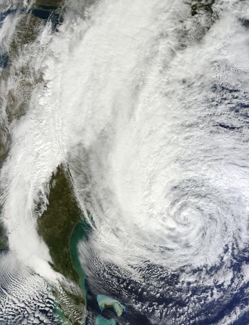
Bottom line: More hurricanes – like Sandy in 2021 – could be in the East Coast’s future, potentially costing billions of dollars in damage and economic losses.
Source: Evolving Tropical Cyclone Tracks in the North Atlantic in a Warming Climate
Via American Geophysical Union
The post Hurricanes expected to linger over cities in US Northeast first appeared on EarthSky.
from EarthSky https://ift.tt/3Ehma95

Aucun commentaire:
Enregistrer un commentaire