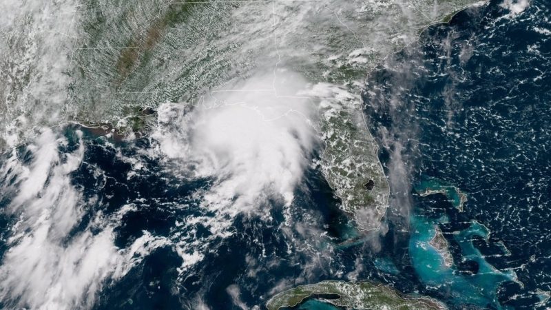

This satellite image is from shortly before landfall, around 1 p.m. CT Tuesday. Image via NOAA / NESDIS Center for Satellite Applications and Research.
Tropical Storm Gordon made landfall along the U.S. Gulf Coast just before 10 p.m. central, according to the National Hurricane Center. The landfall took place just west of the border between the U.S. states of Alabama and Mississippi. Sustained winds were at 70 mph (113 kph), just below hurricane-force. At least one death has been attributed to the storm; an oak tree fell on a mobile home in Pensacola, Florida – where the wind was gusting around 61 mph (98 kph) – reportedly killing a child.
Before a slight decline in wind speed, it was thought that Gordon would be the first Atlantic basin hurricane to make landfall in 2018.
The current path of the storm indicates it will move inland over the lower Mississippi Valley through Wednesday, bringing rain.
Although the center of #Gordon has moved north of the local area, feeder bands may still bring periods of heavy rainfall and isolated tornadoes. The graphics below show those threats are the greatest along the Mississippi Coast. #MSWX #LAWX pic.twitter.com/yyZaOl5CUz
— NWS New Orleans (@NWSNewOrleans) September 5, 2018
In Alabama, about 10,000 power outages were reported, mostly along the coast.
Flash flood warnings went into effect over parts of the western Florida panhandle and southern Alabama. Forecasters were urging people along the Gulf Coast from Louisiana to Florida to be wary of storm surge and flash floods.
By 2 a.m. ET, maximum sustained winds had decreased to 50 mph, with higher gusts. The storm was moving at 14 mph, some 40 miles west of Mobile, Alabama.
Looking at outer rain bands impacting Central Alabama this morning. Just looking at some wet roads. Can't rule out a small risk for an isolated severe storm this afternoon. Threat appears very low but it is a tropical system….we have to watch it. #alwx #WBRCFirstAlert pic.twitter.com/YtfsZGxtdr
— Matt Daniel (@mattdanielwx) September 5, 2018
Visit the National Hurricane Center’s website
Visit the Capital Weather Gang at the Washington Post
from EarthSky https://ift.tt/2oI3Oso

Aucun commentaire:
Enregistrer un commentaire